
The Jebel Akhdar is a heavily forested, fertile upland area in northeastern Libya. It is located in the modern shabiyahs or districts of Derna, Jabal al Akhdar, and Marj.
The Rann of Kutch Wildlife Sanctuary is the largest Ramsar site in Sindh, covering 566,375 ha, and is located in the Rann of Kutch in Badin District, Sindh, Pakistan. In 1980, declared as a wildlife sanctuary by the Government of Sindh, the Rann of Kutch covers the most Ramsar site area as compared to that of any other of the ten Ramsar sites in Sindh province of Pakistan.

The Parc Natural dels Aiguamolls de l'Empordà is a natural park in Catalonia, Spain. It forms part of the Bay of Roses and, like the Ebro Delta, was a malarial swampland. The marshland lies between the Rivers Fluvià and Muga. It is the second largest wetland in Catalonia at over 4,800 hectares and was established in 1983.

The wildlife of Chad is composed of its flora and fauna. West African lions, buffalo, hippopotamuses, Kordofan giraffes, antelopes, African leopards, cheetahs, hyenas, Bush elephants, and many species of snakes are found there, although most large carnivore populations have been drastically reduced since the early 20th century. Elephant poaching, particularly in the south of the country in areas such as Zakouma National Park, is a severe problem.
Mauritania's wildlife has two main influences as the country lies in two biogeographic realms. The north sits in the Palearctic which extends south from the Sahara to roughly 19° north latitude and the south is in the Afrotropic realm. Additionally, Mauritania is an important wintering area for numerous birds which migrate from the Palearctic.
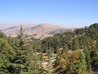
Al Shouf Cedar Nature Reserve is a nature reserve in the Chouf and Aley districts of Lebanon. It is located on the slopes of Jebel Baruk mountain and has an area of 550 km2 (210 sq mi), nearly 5.3% of the Lebanese territory, making it the largest natural reserve in Lebanon.

The wildlife of Libya is spread over the Mediterranean coastline and encompasses large areas of the Saharan desert. The protection of wildlife is provided through appropriate legislation in seven national parks, five reserves, 24 protected areas, two wetlands under Ramsar Convention, and also in other areas. Apart from these, there are also five UNESCO World Heritage Sites related to culture. The most important national parks are the El-Kouf National Park and Karabolli National Park. The well known nature reserves are the Benghazi Reserve and the Zellaf Reserve. The wildlife species recorded in the country are 87 mammals and 338 species of birds.

The Aammiq Wetland is the largest remaining freshwater wetland in Lebanon, a remnant of much more extensive marshes and lakes that once existed in the Bekaa Valley. It has been designated an Important Bird Area in the Middle East, is included in the Directory of Wetlands in the Middle East, was declared Ramsar Convention site number 978 in 1999, and most recently (2005) was designated, with Al Shouf Cedar Nature Reserve, a “Biosphere reserve” by UNESCO.

The Mediterranean woodlands and forests is an ecoregion in the coastal plains, hills, and mountains bordering the Mediterranean Sea and Atlantic Ocean in North Africa. It has a Mediterranean climate, and is in the Mediterranean forests, woodlands, and scrub biome.

The Tibesti-Jebel Uweinat montane xeric woodlands is a deserts and xeric shrublands ecoregion in the eastern Sahara. The woodlands ecoregion occupies two separate highland regions, covering portions of northern Chad, southwestern Egypt, southern Libya, and northwestern Sudan.
Crooked Tree Wild Life Sanctuary (CTWS) is a protected area in Belize. The main goal of the sanctuary is to protect the area for the thousands of waterbirds that migrate to and through it every year.
Protected areas of Libya include any geographical area protected for a specific use.
Ain Elshakika Wetland is a Ramsar-protected wetland of Libya within the El Kouf National Park. The wetland reserve was established in 2000, and covers an area of 33 hectares. The site consists of a hypersaline coastal sebkha with limestone rock formations to the south, dunes and mudflats with extensive shrubs from west to east.
Ain Elzarga Wetland is a Ramsar-protected wetland of Libya. It was established in 2000 and covers an area of 33 hectares. Ramsar says of it: "A small natural sebkha or depression with at least one natural connection to the sea, wet all year round but with increasing water levels and salinity during summer. The sebkha, with mudflats and salt marsh community, is surrounded by dunes from east to west and rocky hills to the south and east. The site is one of the most important wetlands in the area of the El Kouf National Park for migratory waterbirds. The birdwatching and ecotourism potential is considerable but undeveloped. Unsustainable hunting and destruction of vegetation, especially during summer, are considered threats."
Mediterranean Wetlands comprise the wetlands of the Mediterranean region.

Yumurtalık Lagoon is a lagoon located in Adana Province, southern Turkey. The area is a nature reserve, a national park, and is a Ramsar site.

The Buna River-Velipojë Protected Landscape is a protected landscape area in northwestern Albania, encompassing the estuary of Drin, the lagoon of Viluni, the river of Buna with its estuary, and the gulf of Drin that runs across the city of Velipojë alongside the Adriatic Sea.

