Oberkappel

Last updated
Oberkappel
KirchturmOberkappel.jpg
Coat of arms Oberkappel.svg
Oberkappel im Bezirk RO.png
Location in the district
Austria adm location map.svg
Red pog.svg
Oberkappel
Location within Austria
Coordinates: 48°33′11″N13°46′17″E / 48.55306°N 13.77139°E / 48.55306; 13.77139 Coordinates: 48°33′11″N13°46′17″E / 48.55306°N 13.77139°E / 48.55306; 13.77139
Country Austria
State Upper Austria
District Rohrbach
Government
   Mayor Manuel Krenn (ÖVP)
Area
[1]
  Total12.2 km2 (4.7 sq mi)
Elevation
511 m (1,677 ft)
Population
 (2018-01-01) [2]
  Total725
  Density59/km2 (150/sq mi)
Time zone UTC+1 (CET)
  Summer (DST) UTC+2 (CEST)
Postal code
4144
Area code 07284
Vehicle registration RO
Website www.oberkappel.at

Oberkappel is a municipality in the district of Rohrbach in the state of Upper Austria.

Contents

Population

Historical population
YearPop.±%
1869817    
1880775−5.1%
1890778+0.4%
1900737−5.3%
1910763+3.5%
1923751−1.6%
1934698−7.1%
1939710+1.7%
1951724+2.0%
1961737+1.8%
1971736−0.1%
1981824+12.0%
1991779−5.5%
2001766−1.7%
2013733−4.3%
2017749+2.2%
2021713−4.8%

Geography

Oberkappel has an area of 12 km². The municipality is located in the north of the state of Upper Austria. It borders on Germany and is very close to the Czech Republic.

Sports and recreation

The European walking routes E8 and E10 run through this place. The E8 runs from Ireland via, among others, the Netherlands (called Oeverloperpad and Lingepad in the Netherlands) through Germany, the north of Austria and Slovakia to the borders of Poland and the Ukraine, and also includes a section in Bulgaria, with the future target Istanbul in Turkey. The E10 comes from Lapland and runs via Finland, the former GDR, the Czech Republic and Austria to Bozen/Bolzano in northern Italy; There are plans to extend the route via France and the Spanish east coast to Gibraltar.

History

The town was originally part of the Hochstift Passau. According to the Land Registry of Rannariedl in 1581, Oberkappel belonged to the parish Wegscheid. In 1783 it became independent as a parish. During the secularization of 1803, the place with most of the Hochstiftischen area fell into the hands of Archduke Ferdinand of Tuscany and his electorate of Salzburg. The place then came to Bavaria in 1805. Oberkappel has belonged to Upper Austria since 1814 and has been a border town with Bavaria ever since. During the Third Reich, the town belonged to the Gau Oberdonau. During World War II Oberkappel was the place where Allied troops first entered Austrian territory.

Well-known Oberkappellers

Related Research Articles

<span class="mw-page-title-main">Lochau</span> Place in Vorarlberg, Austria

Lochau is a municipality in the westernmost Austrian state of Vorarlberg. It is located on Lake Constance, in the Bregenz district, near the border to Germany.

<span class="mw-page-title-main">Au, Vorarlberg</span> Place in Vorarlberg, Austria

Au is a town in the Bregenz Forest in Vorarlberg (Austria).

<span class="mw-page-title-main">Lofer</span> Place in Salzburg, Austria

Lofer is a market town in the district of Zell am See in the Austrian state of Salzburg.

<span class="mw-page-title-main">Thiersee</span> Place in Tyrol, Austria

Thiersee is a large municipality in the Kufstein district in the Austrian state of Tyrol located 5 km west of Kufstein, below the northern border with Bavaria, Germany.
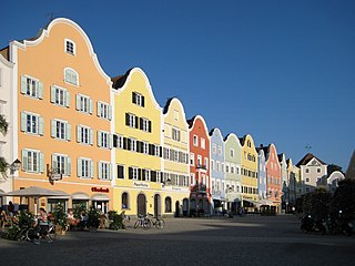
Hohenzell is a municipality in Upper Austria. It is situated in the district of Ried im Innkreis in the Innviertel and has 2,002 inhabitants. The responsible jurisdiction is Ried im Innkreis.

<span class="mw-page-title-main">Neuhofen im Innkreis</span> Place in Upper Austria, Austria

Neuhofen im Innkreis is a municipality in Upper Austria in the district of Ried im Innkreis.

<span class="mw-page-title-main">Mehrnbach</span> Place in Upper Austria, Austria

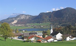
Mehrnbach is a municipality in Upper Austria. It is situated in the district of Ried im Innkreis in the Innviertel.

Hohenau an der March is a town in the district of Gänserndorf in the Austrian state of Lower Austria, close to Vienna and the borders with the Czech Republic and Slovakia.

<span class="mw-page-title-main">Sillian</span> Place in Tyrol, Austria

Sillian is a market town in the district of Lienz, in the Austrian state of Tyrol.

<span class="mw-page-title-main">Obertilliach</span> Place in Tyrol, Austria

Obertilliach is a municipality in the district of Lienz, in the Austrian state of Tyrol.

<span class="mw-page-title-main">Bergheim, Austria</span> Place in Salzburg, Austria

Bergheim is a municipality in the district of Salzburg-Umgebung in the state of Salzburg in Austria. The Plainberg with its Maria Plain pilgrimage church forms the border between Bergheim and the city of Salzburg to the south.

<span class="mw-page-title-main">Langenegg</span> Place in Vorarlberg, Austria

Langenegg is a municipality with approx. 1,200 inhabitants in the westernmost Austrian state, Vorarlberg.

<span class="mw-page-title-main">Sibratsgfäll</span> Place in Vorarlberg, Austria

Sibratsgfäll is a municipality in the district of Bregenz in the Austrian state of Vorarlberg.

<span class="mw-page-title-main">Franking, Austria</span> Place in Upper Austria, Austria

Franking is a municipality in the district Braunau am Inn in the Austrian state of Upper Austria.

<span class="mw-page-title-main">Aschach an der Donau</span> Place in Upper Austria, Austria

Aschach an der Donau is a municipality in the district Eferding in the Austrian state of Upper Austria.

<span class="mw-page-title-main">Gallspach</span> Place in Upper Austria, Austria

Gallspach is a municipality and spa in the district of Grieskirchen in the Austrian state of Upper Austria. Centre of the municipality ist the market town Gallspach. It comprises also the following villages: Enzendorf, Gferedt, Niederndorf, Schützendorf, Thall, Thongraben, Vornwald and Wies.

Dimbach is a municipality in the district Perg in Upper Austria, Austria. It had a population of 1015 according to the 2015 census.

<span class="mw-page-title-main">Schwarzenberg am Böhmerwald</span> Place in Upper Austria, Austria

Schwarzenberg am Böhmerwald is a municipality in the district of Rohrbach in the Austrian state of Upper Austria.

<span class="mw-page-title-main">Andorf</span> Place in Upper Austria, Austria

Andorf is a municipality in the district of Schärding in Upper Austria, Austria. As of 2008, it had a population of 5,023.

<span class="mw-page-title-main">Bad Leonfelden</span> Place in Upper Austria, Austria

Bad Leonfelden is a municipality in the district of Urfahr-Umgebung in the Austrian state of Upper Austria. Steven Beller, author of A Concise History of Austria, who has family links to Bad Leonfelden, cites episodes from the town's history from its foundation in 1292 to the 21st century, to demonstrate the impact of historical and political events on the local life in Austria's rural provinces. The Jugendstil mosaicist Leopold Forstner was born there.

References

  1. "Dauersiedlungsraum der Gemeinden Politischen Bezirke und Bundesländer - Gebietsstand 1.1.2018". Statistics Austria. Retrieved 10 March 2019.
  2. "Einwohnerzahl 1.1.2018 nach Gemeinden mit Status, Gebietsstand 1.1.2018". Statistics Austria. Retrieved 9 March 2019.