Ocean View (Norfolk)

Last updated

East Beach in Ocean View, along the Chesapeake Bay Ocean View Norfolk - East Beach.jpg
East Beach in Ocean View, along the Chesapeake Bay

Ocean View is a coastal region in the independent city of Norfolk, Virginia in the United States. It has several miles of shoreline on the Chesapeake Bay to the north, starting with Willoughby Spit to the west and the Joint Expeditionary Base -- Little Creek in the independent city of Virginia Beach on the east.

Contents

Shire to County to City

The entire area of South Hampton Roads was part of Elizabeth River Shire when it was formed in 1634. From this original shire (or county), in 1636, New Norfolk County was formed, which was divided again into Upper and Lower Norfolk counties in 1637. Lower Norfolk County was split in 1691 to form Princess Anne County and Norfolk County. [ citation needed ]

The Ocean View area was to remain part of Norfolk County for over 225 years, until it and the adjacent Willoughby Spit area were annexed by the independent City of Norfolk in 1923. (Virginia has had independent city political subdivisions since 1871). A small portion of East Ocean View adjacent to the Little Creek Amphibious Base was added in a land-swap with the city of Virginia Beach in 1988. [ citation needed ]

Ocean View City: Trolleys, Famous Amusement Park

The area which became known as Ocean View City was originally a 360-acre (1.5 km2) tract called the Magagnos Plantation which had extensive frontage on the Chesapeake Bay east of Willoughby Spit and west of Little Creek. [ citation needed ]

The Ocean View area was surveyed and laid out with streets and lots as Ocean View City in 1854 by William Mahone, a young civil engineer who was building the Norfolk and Petersburg Railroad. Under the leadership of Walter H. Taylor, about 30 years later, a narrow gauge steam passenger railroad service was established between Norfolk and Ocean View, a 9-mile long line [1] crossing what was then known as Tanner's Creek (later renamed Lafayette River). Originally named the Ocean View Railroad, it was later known as the Norfolk and Ocean View Railroad. [2] A small steam locomotive named the General William B. Mahone hauled ever increasing volumes of passengers, primarily on the weekends. The steam service was later replaced by electric-powered trolley cars, becoming both a popular resort and a streetcar suburb of the City of Norfolk. Initially, the improvements consisted of the swimming beach and cottages. The location was quite popular for Sunday outings from Norfolk.

The popular Nansemond Hotel was built about 1928; it was destroyed in a fire in 1980. [3]

With the advent of additional electric streetcars in the late 19th century, an amusement park was developed at the end-of-the-line and a boardwalk was built along the adjacent beach area. These were a favorite of sailors on leave from the Norfolk Navy Base. Buses replaced the streetcars in the late 1940s. In the mid 20th century, for a number of years, AM radio station WGH broadcast live from a booth under the roller coaster.

Completion of the Hampton Roads Bridge-Tunnel in 1957 connected the Ocean View area to the Virginia Peninsula. However, it and other newer highways encouraged visitors to continue on to the Virginia Beach resort area on the Atlantic Ocean, a small city which boomed after merging with Princess Anne County in 1963. In particular, construction of nearby Interstate 64 and the Virginia Beach Expressway (now part of Interstate 264) made it easier for tourists from afar to bypass Ocean View en route to the Oceanfront area of Virginia Beach.

Decline, Reemergence

After several years of decline in the 1970s, during which Busch Gardens in Williamsburg opened less than an hour's drive away, Ocean View Amusement Park was closed after Labor Day, 1978 and was torn down soon after the filming of a 1979 made-for-TV movie called The Death of Ocean View Park, which starred Mike Connors of Mannix fame, Barry Newman, and Academy Award winner Martin Landau. A key scene featured blowing up the landmark wooden roller coaster "The Rocket". While there had been popular concern as to the structural integrity of the famous but aged wooden structure, early attempts to film its destruction with explosives met with failure. Finally, on the third attempt, and with a bulldozer off camera helping to pull the structure down, the landmark appeared to explode in a large fireball. Also, the 1977 movie Rollercoaster (with Timothy Bottoms), George Segal, Henry Fonda, and Richard Widmark, features "The Rocket", as well as other shots of the park in the opening sequences.

In the early 21st century, as the entire coastal property market surged with new growth, redevelopment in the Ocean View community has resulted in new upscale residential properties replacing old beach cottages and small motels along the resort strip. Property values, especially bay front property, particularly in the East Beach neighborhood, have increased significantly in value. [4]

Today, U.S. Route 60 is the main roadway paralleling the bay along the resort strip on Ocean View Avenue. U.S. Route 460 begins at its junction in front of the site of the former amusement park, where a city park and a high rise condominium is now located.

East Beach

In a large-scale urban renewal project begun in the 1990s, the city of Norfolk invested over $50 million to develop, as part of a public-private partnership, an upscale new urbanist waterfront neighborhood named "East Beach" in East Ocean View. As part of the project, the city acquired and tore down more than 1,600 buildings across 100 acres, and relocated hundreds of low-income residents. [5] [6] The master plan for the neighborhood was designed by Andrés Duany with Duany Plater-Zyberk. [7] The neighborhood is fashioned after classic Southeastern seaboard coastal villages, and includes 700 residences, neighborhood restaurants, boutique shops, a Bay Front Club, offices, parks and public places. [8]

In 2003, a massive beach restoration project was completed by the city, the U.S. Army Corps of Engineers, and the Virginia Port Authority, which involved a large-scale rebuilding of sand dunes, planting of vegetation, and the placement of 10 offshore breakwaters to slow erosion and protect the neighborhood from coastal storms. In 2007, the American Shore and Beach Preservation Association named East Beach one of the nation's top seven restored beaches. [9]

Ocean View Fishing Pier

Not only was the Amusement Park well known to the region, so was Harrison's Fishing Pier. Owned by Bill Harrison and managed by Charlie Woodard. It was heavily damaged during Hurricane Isabel in September, 2003. A new pier was built, called the Ocean View Fishing Pier. [10] Now owned by Ronnie Boone Jr., it continues to be an Ocean View landmark and attraction. This fishing pier is 1,690 feet long and considered the longest fishing pier in North America.

See also

Related Research Articles

<span class="mw-page-title-main">Norfolk, Virginia</span> Independent city in Virginia, United States

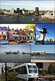
Norfolk is an independent city in Virginia, United States. As of the 2020 census, Norfolk had a population of 238,005, making it the third-most populous city in Virginia after neighboring Virginia Beach and Chesapeake, and the 94th-largest city in the nation. Norfolk holds a strategic position as the historical, urban, financial, and cultural center of the Hampton Roads region, which has more than 1.8 million inhabitants and is the 37th-largest metropolitan area in the US, with ten cities.

<span class="mw-page-title-main">Virginia Beach, Virginia</span> Largest city in Virginia, United States

Virginia Beach is an independent city located on the southeastern coast of Virginia, United States. The population was 459,470 at the 2020 census. Although mostly suburban in character, it is the most populous city in Virginia, fifth-most populous city in the Mid-Atlantic, ninth-most populous city in the Southeast and the 42nd-most populous city in the U.S. Located on the Atlantic Ocean at the mouth of the Chesapeake Bay, Virginia Beach is the largest city in the Hampton Roads metropolitan area which includes 6 other cities. This area, sometimes referred to as "America's First Region", also includes the independent cities of Chesapeake, Hampton, Newport News, Norfolk, Portsmouth, and Suffolk, as well as other smaller cities, counties, and towns of Hampton Roads.

<span class="mw-page-title-main">Jacksonville Beach, Florida</span> City in Florida, United States

Jacksonville Beach is a coastal resort city in Duval County, Florida, United States. It was incorporated on May 22, 1907, as Pablo Beach, and would later change its name to Jacksonville Beach in 1925. The city is part of group of communities collectively referred to as the Jacksonville Beaches. These communities include Mayport, Atlantic Beach, Neptune Beach, and Ponte Vedra Beach. When the city of Jacksonville consolidated with Duval County in 1968, Jacksonville Beach, together with Atlantic Beach, Neptune Beach, and Baldwin, voted to retain their own municipal governments. As a result, citizens of Jacksonville Beach are also eligible to vote in mayoral election for the City of Jacksonville. As of the 2010 census, Jacksonville Beach had a total population of 21,362.

<span class="mw-page-title-main">Ocean City, Maryland</span> Town in Maryland, United States

Ocean City, officially the Town of Ocean City, is an Atlantic resort town in Worcester County, Maryland, along the East Coast of the United States. The population was 6,844 at the 2020 U.S. census, although during summer weekends the city hosts between 320,000 and 345,000 vacationers and up to eight million visitors annually. During the summer, Ocean City becomes the second most populated municipality in Maryland, after Baltimore. It is part of the Salisbury metropolitan area as defined by the United States Census Bureau.

<span class="mw-page-title-main">Wrightsville Beach, North Carolina</span> Town in North Carolina, United States

Wrightsville Beach is a town in New Hanover County, North Carolina, United States. Wrightsville Beach is just east of Wilmington and is part of the Wilmington Metropolitan Statistical Area. The population was 2,477 at the 2010 census. The town consists of a 4-mile (6 km) long beach island, an interior island called Harbor Island, and pockets of commercial property on the mainland. It served as a filming location of Dawson's Creek.

<span class="mw-page-title-main">Trolley park</span> Amusement park prototype

In the United States, trolley parks, which started in the 19th century, were picnic and recreation areas along or at the ends of streetcar lines in most of the larger cities. These were precursors to amusement parks. Trolley parks were often created by the streetcar companies to give people a reason to use their services on weekends.

<span class="mw-page-title-main">Jersey Shore</span> Coastal region of the U.S. state of New Jersey

The Jersey Shore is the coastal region of the U.S. state of New Jersey. Geographically, the term encompasses about 141 miles (227 km) of oceanfront bordering the Atlantic Ocean, from Perth Amboy in the north to Cape May Point in the south. The region includes Middlesex, Monmouth, Ocean, Atlantic, and Cape May counties, which are in the central and southern parts of the state. Located in the center of the Northeast Megalopolis, the northern half of the shore region is part of the New York metropolitan area, while the southern half of the shore region is part of the Philadelphia metropolitan area, also known as the Delaware Valley. The Jersey Shore hosts the highest concentration of oceanside boardwalks in the United States.

<span class="mw-page-title-main">Ocean Beach, San Diego</span> Community of San Diego in California, United States

Ocean Beach is a beachfront neighborhood of San Diego, California.

<span class="mw-page-title-main">Sewell's Point</span> Landform in Norfolk, Virginia, U.S.

Sewells Point is a peninsula of land in the independent city of Norfolk, Virginia in the United States, located at the mouth of the salt-water port of Hampton Roads. Sewells Point is bordered by water on three sides, with Willoughby Bay to the north, Hampton Roads to the west, and the Lafayette River to the south. It is the site of Naval Station Norfolk.

<span class="mw-page-title-main">Willoughby Spit</span> Landform in Virginia

Willoughby Spit is a peninsula of land in the independent city of Norfolk, Virginia in the United States. It is bordered by water on three sides: the Chesapeake Bay to the north, Hampton Roads to the west, and Willoughby Bay to the south.

<span class="mw-page-title-main">Norfolk County, Virginia</span>

<span class="mw-page-title-main">Buckroe Beach, Hampton, Virginia</span>

Buckroe Beach is a neighborhood in the independent city of Hampton, Virginia. It lies just north of Fort Monroe on the Chesapeake Bay. One of the oldest recreational areas in the state, it was long located in Elizabeth City County near the downtown area of the lost town of Phoebus prior to their consolidation with Hampton in 1952.

<span class="mw-page-title-main">Virginia Beach Boulevard</span>

Virginia Beach Boulevard is a major connector highway which carries U.S. Route 58 most of its length and extends from the downtown area of Norfolk to the Oceanfront area of Virginia Beach, passing through the newly developed New Urbanist Town Center development of the latter as it links the two independent cities in the South Hampton Roads subregion of the Hampton Roads region in southeastern Virginia.

<span class="mw-page-title-main">U.S. Route 60 in Virginia</span> Section of U.S. Numbered Highway in Virginia, United States

U.S. Route 60 (US 60) in the Commonwealth of Virginia runs 303 miles (488 km) west to east through the central part of the state, generally close to and paralleling the Interstate 64 corridor, except for the crossing of the Blue Ridge Mountains, and in the South Hampton Roads area.

<span class="mw-page-title-main">History of Virginia Beach, Virginia</span>

The history of Virginia Beach, Virginia, goes back to the Native Americans who lived in the area for thousands of years before the English colonists landed at Cape Henry in April 1607 and established their first permanent settlement at Jamestown a few weeks later. The Colonial Virginia period extended until 1776 and the American Revolution, and the area has been part of the Commonwealth of Virginia ever since.

<span class="mw-page-title-main">History of Norfolk, Virginia</span> Aspect of history

The history of Norfolk, Virginia as a modern settlement begins in 1636. The city formally was incorporated in 1736. The city was burned by orders of the outgoing Virginia governor Lord Dunmore in 1776 during the second year of the American Revolutionary War (1775–1783), although it was soon rebuilt.

<span class="mw-page-title-main">Santa Monica State Beach</span> State beach in Los Angeles County, California, United States

Santa Monica State Beach is a California State Park operated by the city of Santa Monica.

<span class="mw-page-title-main">Fort Smallwood Park</span> Historic fort and park in Anne Arundel County, Maryland

Fort Smallwood Park is a in northeastern Anne Arundel County county park near Riviera Beach and Pasadena, Maryland, United States. It is located on the outer Patapsco River as it meets the Chesapeake Bay, on a peninsula known as Rock Point.

References

  1. "Norfolk and Ocean View Railroad, 1879".
  2. "Norfolk and Ocean View Railroad, 1879".
  3. UPI Archives - Landmark Hotel Burned to Ground, 11/24/1980
  4. Messina, Debbie. "Norfolk's East Beach revives prime real estate". Virginian-Pilot. Retrieved February 26, 2019.
  5. Guagenti, Toni. "Proponents say East Beach has astounded from start". Virginian-Pilot. Retrieved February 26, 2019.
  6. Messina, Debbie. "Norfolk's East Beach revives prime real estate". Virginian-Pilot. Retrieved February 26, 2019.
  7. Kruse, Meredith (May 2, 2002). "Plans for East Beach Get New Look". Virginian-Pilot.
  8. "Andrés Duany Designs Condominiums in East Beach" (PDF). East Beach Co. Press Release. October 2006. Retrieved February 26, 2019.
  9. Virginian-Pilot, The. "Norfolk's East Beach named one of nation's top restored beaches". Virginian-Pilot. Retrieved February 26, 2019.
  10. "Ocean View Fishing Pier in Norfolk , VA".

36°57′00″N76°14′47″W / 36.95000°N 76.24639°W / 36.95000; -76.24639