Ohio State Route 668

Last updated
OH-668.svg
State Route 668
OH 668 map.svg
Route information
Maintained by ODOT
Length29.24 mi [1] (47.06 km)
Existed1937–present
Major junctions
South endOH-93.svg SR 93 near Logan
 US 22.svg US 22 in Somerset
I-70.svg I-70 near Brownsville
North endUS 40.svg US 40 in Brownsville
Location
Counties Hocking, Perry, Licking
Highway system
OH-666.svg SR 666 OH-669.svg SR 669

State Route 668 (SR 668) is a north-south state highway in central Ohio. Its southern terminus is at an intersection with SR 93 in the Wayne National Forest, northeast of Logan; its northern terminus is at an intersection with US 40 in the unincorporated community of Brownsville.

Contents

Route description

SR 668 begins at SR 93 in Falls Township, about 5 miles (8.0 km) northeast of Logan. The route heads north and almost immediately exits Hocking County and enters Perry County. For the first 4 miles (6.4 km) of the route, the route is also within the boundaries of the Wayne National Forest. The route reaches Junction City and reaches SR 37 in the center of town. The two routes run together west on Main Street out of town. Shortly after leaving the village, the two routes separate, SR 37 continues west while SR 668 heads north. Upon entering Somerset, the road name becomes Market Street and eventually reaches US 22 (Main Street). SR 668 turns right onto US 22 and the two routes head towards the center of Somerset. SR 13 (Columbus Street) intersects Main Street at a traffic circle in the center of town. The circle houses a memorial to General Philip Sheridan who was born in Somerset. At the eastern village limits, SR 668 splits from US 22 and heads north. North of Somerset, there is a stop-controlled intersection with SR 204 where only travelers on SR 668 must stop. The route then passes a former railroad and makes a sharp turn towards the southeast at Hopewell Township Road 65. It heads up the side of a hill as it gradually curves back to the north. The route passes the Suburban Landfill before it exits Perry County and enters Licking County. After entering Licking County, SR 668 reaches a partial interchange with I-70. Known as exit 141 on I-70, the interchange only provides eastbound travelers on I-70 the opportunity to connect to SR 668 and access to I-70 westbound only from SR 668. After I-70, the route enters the unincorporated community of Brownsville (within Bowling Green Township). SR 668 comes to an end at an intersection with US 40 (National Road). Travelers that need to access I-70 eastbound can head east on US 40 and access I-70 in the nearby village of Gratiot. [2]

History

SR 668 was brought into the state highway system in 1937 on a route longer than it runs today. [3] [4] At its first designation, the route ran from SR 75 (now SR 93) near Logan, past Brownsville on Brownsville Road (now County Road 668) to SR 16 near Hanover. [4] [5] One year later, SR 668 took over the entire route of SR 207; SR 668 shared a short concurrency west on SR 16, went northeast into Hanover and Perryton, and traveled north to its end at SR 79 near Fallsburg. [6] By 1959, the route was shortened to its current length. [7] [8]

Major junctions

CountyLocationmi [1] kmDestinationsNotes
Hocking Falls Township 0.000.00OH-93.svg SR 93   Logan, New Straitsville
Perry Junction City 10.3516.66OH-37.svg SR 37 east (Main Street) / Logan Street  New Lexington Southern end of SR 37 concurrency
Jackson Township 11.1617.96OH-37.svg SR 37 west  Lancaster Northern end of SR 37 concurrency
Somerset 17.0427.42US 22.svg US 22 west (West Main Street) / North Market Street  Rushville, Lancaster Southern end of US 22 concurrency
17.2127.70OH-13.svg SR 13 (Columbus Street)Traffic circle
17.8028.65US 22.svg US 22 east  Zanesville Northern end of US 22 concurrency
Hopewell Township 22.9336.90OH-204.svg SR 204   Glenford, Mount Perry
Licking Bowling Green Township 28.4345.75I-70.svg I-70 west  Columbus Exit 141 (I-70); access from eastbound I-70 / to westbound I-70 only
29.2447.06US 40.svgTo plate blue.svg
I-70.svg
US 40 (National Road) to I-70 east / Third Street  Hebron, Gratiot, Zanesville, Flint Ridge
1.000 mi = 1.609 km; 1.000 km = 0.621 mi

Related Research Articles

Ohio State Route 281

State Route 281 is an east–west state highway in the northwestern portion of the U.S. state of Ohio. Its western terminus is at U.S. Route 24 approximately four miles (6.4 km) northeast of downtown Defiance, and its eastern terminus is at US 6 nearly one mile (1.6 km) north of Bradner. The majority of the route is known as the Defiance Pike.

Ohio State Route 26

State Route 26 is a 67-mile-long (108 km) north–south route in south eastern Ohio spanning from SR 7 in Marietta to SR 148 between Jerusalem and Bethesda. SR 26 also passes through Graysville and Woodsfield. Where the state route designation ends in Wayne Township, the road continues north as Belmont County Road 26 where it connects to the Barkcamp State Park and the National Road. Much of the route parallels the Little Muskingum River and travels through the heart of Wayne National Forest's Marietta Unit.

Ohio State Route 220

State Route 220 is an east–west state highway in the south central portion of the U.S. state of Ohio. Its western terminus is at SR 772 about 8.25 miles (13.28 km) west of Waverly, and its eastern terminus is at the SR 32/SR 124 concurrency 3 miles (4.8 km) east of Piketon. The entire route is in Pike County.

Ohio State Route 49

State Route 49 is a state highway in the western part of the U.S. state of Ohio. It begins in Drexel, an area within the city of Trotwood, at US 35 and runs northwesterly to Greenville, and then runs roughly along near the western edge of the state near the Indiana state line to the Michigan state line where it meets with Michigan's M-49.

Ohio State Route 204

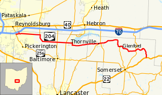
State Route 204 is a state route in central Ohio. It starts at SR 256 in Pickerington, and ends at US 22 near Mount Perry. At a length of 37.79 miles (60.82 km), the route is located parallel to Interstate 70 in Fairfield and Perry counties east of Columbus, the state capital.

Ohio State Route 571

State Route 571 is an east–west state highway in west-central Ohio, part of a statewide road transportation system. It indirectly connects the cities of Union City and Greenville with Springfield via a final 10.7 miles (17.2 km) on U.S. Route 40.

Ohio State Route 211

State Route 211 (SR 211) is a 1.23-mile-long (1.98 km) north–south state highway in the eastern portion of the U.S. state of Ohio. Though physically it runs in a northwesterly–southeasterly direction, according to the Ohio Department of Transportation (ODOT) and signage on the route itself its southern terminus is located north of its northern terminus. The unusual directional signage is a vestige of when SR 211 traveled further south acting as a bypass of New Philadelphia and Dover. The highway runs from its signed southern terminus at a signalized intersection with SR 39 on the border of the city of Dover and Dover Township, just one block east of exit 83 off the Interstate 77 (I-77)/U.S. Route 250 (US 250) freeway, to its signed northern terminus at a signalized intersection with SR 800 near downtown Dover.

Ohio State Route 754

State Route 754 is a two-lane north–south state highway that runs within Holmes County, Ohio. The southern terminus of SR 754 is at the intersection that marks the eastern split of the concurrency of SR 39 and SR 60 approximately 5.5 miles (8.9 km) northwest of Millersburg. Its northern terminus is at SR 514 about 2 miles (3.2 km) southwest of Shreve.

Ohio State Route 374

State Route 374 is north–south state highway in Hocking County, Ohio, located in the southern portion of the state. Its southern terminus is over 4 miles (6.4 km) east of the unincorporated village of South Bloomingville at State Route 56, and its northern terminus is near the unincorporated village of Rockbridge at US 33, west of Logan. The road serves Hocking State Forest as well as Hocking Hills State Park, and the entire highway is part of the designated Hocking Hills Scenic Byway.

Ohio State Route 542

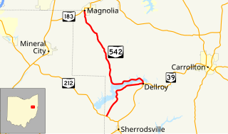
State Route 542 is a state highway in western Carroll County, within the eastern side of Ohio. The route runs 15.8 miles (25.4 km) long and connects SR 212 near Sherrodsville to Magnolia at SR 183 by way of Dellroy and Atwood Lake.

Ohio State Route 646

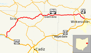
State Route 646 is a 28.78-mile-long (46.32 km) state highway in Harrison and Jefferson Counties in eastern Ohio. The route runs from US 250 in Stock Township, northwest of Cadiz, to SR 43 in Island Creek Township, just outside Wintersville.

Ohio State Route 647

State Route 647 is a state highway in eastern Ohio connecting the city of Martins Ferry with the village of Mount Pleasant. 9.96 miles (16.03 km) in length, its southern terminus is at SR 7 and its northern terminus is at SR 150.

Ohio State Route 674

State Route 674 is a state highway located southeast of Columbus, Ohio. Most of the route straddles a county line; about 11 miles (18 km) of the southern part of route is on the Pickaway–Fairfield County line while the next 1.4 miles (2.3 km) is on the Fairfield-Franklin County line. The route's southern terminus is at US 22 just north of Stoutsville while the northern terminus is at an interchange with US 33 in the city of Canal Winchester.

Ohio State Route 729

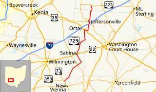
State Route 729 is a state highway in central Ohio. The 33.58-mile-long (54.04 km) route runs from SR 73 and SR 350 in the community of Snow Hill, northwest of New Vienna to SR 323 north of Jeffersonville.

References

Route map:

KML file (edithelp)
    KML is from Wikidata
    1. 1 2 Ohio Department of Transportation. "Technical Services Straight Line Diagrams" . Retrieved October 26, 2013.
    2. Google (October 26, 2013). "Ohio State Route 668" (Map). Google Maps . Google. Retrieved October 26, 2013.
    3. 1936 Official Highway Map (MrSID) (Map). Cartography by John Jaster, Jr., Director. Ohio Department of Highways. 1936. Retrieved August 19, 2013.
    4. 1 2 Official Ohio Highway Map 1937 (MrSID) (Map). Cartography by John Jaster, Jr., Director. ODOH. 1937. Retrieved August 19, 2013.
    5. Licking County (PDF) (Map). ODOT. June 2012. Retrieved October 26, 2013.
    6. Official 1938 Ohio Highway Map (MrSID) (Map). Cartography by John Jaster, Jr., Director. ODOH. 1938. Retrieved August 19, 2013.
    7. 1958–1959 Official Ohio Highway Map (MrSID) (Map). Cartography by Charles M. Noble, Director of Highways. ODOH. 1958. Retrieved September 23, 2013.
    8. Ohio Official Highway Map (MrSID) (Map). Cartography by E.S. Preston, Director. ODOH. 1959. Retrieved September 23, 2013.