A valley is an elongated low area often running between hills or mountains, which will typically contain a river or stream running from one end to the other. Most valleys are formed by erosion of the land surface by rivers or streams over a very long period of time. Some valleys are formed through erosion by glacial ice. These glaciers may remain present in valleys in high mountain or polar areas. At lower latitudes and altitudes, these glacially formed valleys may have been created or enlarged during ice ages but now are ice-free and occupied by streams or rivers. In desert areas, valleys may be entirely dry or carry a watercourse only rarely. In areas of limestone bedrock, dry valleys may also result from drainage taking place underground rather than at the surface. Rift valleys arise principally from earth movements, rather than erosion. Many different types of valley are described by geographers, using terms that may be global in use or else applied only locally.
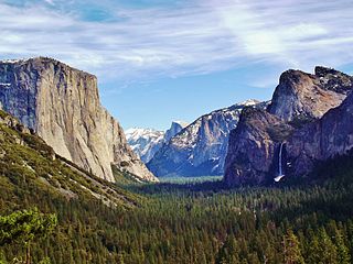
Yosemite Valley is a glacial valley in Yosemite National Park in the western Sierra Nevada mountains of Central California. The valley is about 7.5 miles (12 km) long and approximately 3000–3500 feet deep, surrounded by high granite summits such as Half Dome and El Capitan, and densely forested with pines. The valley is drained by the Merced River, and a multitude of streams and waterfalls flow into it, including Tenaya, Illilouette, Yosemite and Bridalveil Creeks. Yosemite Falls is the highest waterfall in North America and is a big attraction especially in the spring, when the water flow is at its peak. The valley is renowned for its natural environment and is regarded as the centerpiece of Yosemite National Park, attracting visitors from around the world.

The Colorado Plateau, also known as the Colorado Plateau Province, is a physiographic and desert region of the Intermontane Plateaus, roughly centered on the Four Corners region of the southwestern United States. This province covers an area of 336,700 km2 (130,000 mi2) within western Colorado, northwestern New Mexico, southern and eastern Utah, northern Arizona, and a tiny fraction in the extreme southeast of Nevada. About 90% of the area is drained by the Colorado River and its main tributaries: the Green, San Juan, and Little Colorado. Most of the remainder of the plateau is drained by the Rio Grande and its tributaries.
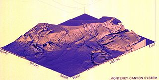
Monterey Canyon, or Monterey Submarine Canyon, is a submarine canyon in Monterey Bay, California with steep canyon walls measuring a full 1 mile in height from bottom to top, which height/depth rivals the depth of the Grand Canyon itself. It is the largest such submarine canyon along the West coast of the North American continent, and was formed by the underwater erosion process known as turbidity current erosion. Many questions remain unresolved regarding the exact nature of its origins, and as such it is the subject of several ongoing geological and marine life studies being carried out by scientists stationed at the nearby Monterey Bay Aquarium Research Institute, the Moss Landing Marine Laboratories, and other oceanographic institutions.

U-shaped valleys, trough valleys or glacial troughs, are formed by the process of glaciation. They are characteristic of mountain glaciation in particular. They have a characteristic U shape in cross-section, with steep, straight sides and a flat or rounded bottom. Glaciated valleys are formed when a glacier travels across and down a slope, carving the valley by the action of scouring. When the ice recedes or thaws, the valley remains, often littered with small boulders that were transported within the ice, called glacial till or glacial erratic.

Canyon Lake Gorge is a limestone gorge in Texas, which is around 1 mile (1.6 km) long, hundreds of yards (metres) wide, and up to 50 feet (15 m) or more deep, which was exposed in 2002 when extensive flooding of the Guadalupe River led to a huge amount of water going over the spillway from Canyon Lake reservoir and removing the sediment from the gorge. The gorge provides a valuable exposure of rock strata as old as 6000 years showing fossils and a set of dinosaur tracks, and forms a new ecosystem for wildlife with carp and other creatures in a series of pools fed by springs and waterfalls.

Rugova Canyon or Rugova Gorge is a river canyon near Peja in Western Kosovo, in the Prokletije mountains, close to the border with Montenegro. With a length of 25 km (16 mi) and a depth up to 1,000 meters, Rugova is considered to be one of Europe's longest and deepest canyons. It was created by water erosion and the retreat of the Peja glacier. The Peja Bistrica river cuts through the canyon.
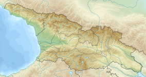
Khoni is a district of Georgia, in the region of Imereti. Its main town is Khoni.

Mirusha is a regional park located in the central part of Kosovo on the eastern side of the Dukagjin plain.
Balda Canyon Natural Monument is an Abasha gorge located in Samegrelo region of Western Georgia in Martvili Municipality near village Second Balda and Balda Monastery of St. Mary's Assumption, 295 meters above sea level. Canyon created by limestone rocks in the southern part of the Ashkah massif by the Abasha River. Baldi Canyon is 1400 m long, 5-10 m wide and 25-30 m deep.

Gabzaruli Tba Natural Monument also known as Cracked Lake Natural Monument is a small siphon lake in Georgia region Imereti, Tskaltubo Municipality, in the village Kumistavi, 166 meters above the sea level. The villagers also call it Tskrvaram. Gabzaruli Tba or Cracked Lake is about 5 m long, 4.5 m wide and 60 m deep. The siphon lake is part of unexplored cave system and lies in a 45 m deep canyon created by tectonic rupture. Steep canyon slopes are covered with deciduous forest. Villagers use lake water for drinking and also do fishing and swimming in the lake.

Nazodelavo Cave Natural Monument is a karst cave 6.8 km to the north from village Akhuti in Chkhorotsqu Municipality in Samegrelo-Zemo Svaneti region of Georgia. Cave is located on the left bank of river Zana, 290 meters above sea level. Nazodelavo means the dwelling of Zodelavos. According to cave narratives, it was used as a means of defense in the middle ages.
Melouri Cave Natural Monument is a karst cave located near village Melouri in Tsqaltubo Municipality in Imereti region of Georgia, 418 meters above sea level. Melouri Cave is one of the largest caves in Georgia. It is part of extensive Tsqaltubo Cave system which also includes nearby cave Didghele.

Toba Waterfall and Arsen Okrojanashvili Cave Natural Monument is the highest in Georgia cascading waterfall of 234 m height and a karst cave complex located 5.6 km to the west from village First Balda in Martvili Municipality, Samegrelo-Zemo Svaneti region of Georgia. It is located at 707 metres above sea level on the left bank of Toba river, left-bank tributary of Abasha river and can be reached by marked hiking trail.

Samshvilde Canyon Natural Monument is part of Khrami gorge that provided natural defense to fortress Samshvilde in the area around confluence of the rivers Khrami and Chivchavi near Samshvilde village and ruins of historic Samshvilde located in Tetritsqaro Municipality, in Kvemo Kartli region of southeastern Georgia, 548-605 meters above sea level. Samshvilde Canyon also include part of Chivchav (Chivchava) gorge in the same location, since historically it also was part of fortress Samshvilde natural defences.

Dashbashi Canyon Natural Monument is part of Khrami gorge near Dashbashi village, 3 km from small town of Tsalka, in Tsalka Municipality, in Kvemo Kartli region of southeastern Georgia, 1,110-1,448 meters above sea level. The distance from Dashbashi Canyon Natural Monument to the popular Algeti National Park is 42 km.

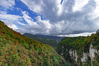
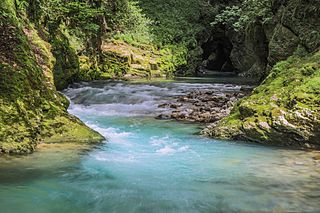
Gachedili Canyon Natural Monument also known as Abasha Canyon Natural Monument and Martvili Canyon is an Abasha river erosion canyon located in Samegrelo region of Western Georgia in Martvili Municipality near Gachedili village, 240 meters above sea level. The water in the Abasha river has deep green color in the canyon. The Gachedili Canyon Natural Monument is located 6 km from the popular Balda Canyon Natural Monument. A canyon visitor center is located in the village Great Inchkhuri on the northern outskirts of the Martvili.

Kinchkha Waterfall Natural Monument is a cascade waterfall in Khoni Municipality, Imereti region of Georgia near village Kinchkha in the river gorge of Okatse (Satsikvilo) at 843 meters above sea level. Kinchkha Waterfall has three steps in the chalkstone slopes: the upper step with 25m height drop, the main waterfall with 70 meter height drop and the third one with 20 meters high drop, which has additional water supply from the small streams. The main waterfall created huge siphons in a flatland. It is possible to visit Kinchka waterfall and nearby Lomina waterfall by marked trails, however typical tourist infrastructure is not arranged.