Tbilisi, in some languages still known by its pre-1936 name Tiflis, is the capital and the largest city of Georgia, lying on the banks of the Kura River with a population of approximately 1.5 million people. Tbilisi was founded in the 5th century AD by Vakhtang I of Iberia, and since then has served as the capital of various Georgian kingdoms and republics. Between 1801 and 1917, then part of the Russian Empire, Tiflis was the seat of the Caucasus Viceroyalty, governing both the northern and the southern parts of the Caucasus.

Prince Ilia Chavchavadze was a Georgian public figure, journalist, publisher, writer and poet who spearheaded the revival of Georgian nationalism during the second half of the 19th century and ensured the survival of the Georgian language, literature, and culture during the last decades of Tsarist rule. He is Georgia's "most universally revered hero" and is regarded as the "Father of the Nation."

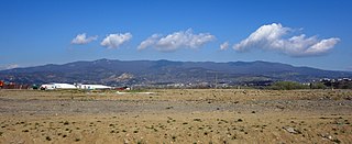
Mtskheta is a city in Mtskheta-Mtianeti province of Georgia. One of the oldest cities of Georgia and its former capital, it is located approximately 20 km (12 mi) north of Tbilisi, at the confluence of the Mtkvari and Aragvi rivers. Currently a small provincial capital, for nearly a millennium until the 5th century AD, Mtskheta was a large fortified city, a significant economical and political centre of the Kingdom of Iberia.

Shida Kartli is a landlocked administrative region (Mkhare) in eastern Georgia. It comprises a central part of the historical-geographic province of Shida Kartli. With an area of 5,729 square kilometres (2,212 sq mi), Shida Kartli is the 8th largest Georgian region by land area. With 284,081 inhabitants, it is Georgia's seventh-most-populous region. Shida Kartli's capital and largest city, Gori, is the 5th largest city in Georgia.

The subdivisions of Georgia are autonomous republics, regions, and municipalities.

Kartli is a historical region in central-to-eastern Georgia traversed by the river Mtkvari (Kura), on which Georgia's capital, Tbilisi, is situated. Known to the Classical authors as Iberia, Kartli played a crucial role in the ethnic and political consolidation of the Georgians in the Middle Ages. Kartli had no strictly defined boundaries and they significantly fluctuated in the course of history. After the partition of the kingdom of Georgia in the 15th century, Kartli became a separate kingdom with its capital at Tbilisi. The historical lands of Kartli are currently divided among several administrative regions of Georgia.

Kvemo Kartli is a historic province and current administrative region (mkhare) in southeastern Georgia. The city of Rustavi is a regional capital.

Zedazeni Monastery is a Georgian Orthodox monastery, located on the Zedazeni mountain the hills of Saguramo, northeast to Mtskheta and to the east side of the Aragvi River.

Stepantsminda, is a townlet in the Mtskheta-Mtianeti region of north-eastern Georgia. Historically and ethnographically, the town is part of the Khevi province. It is the center of the Kazbegi Municipality.
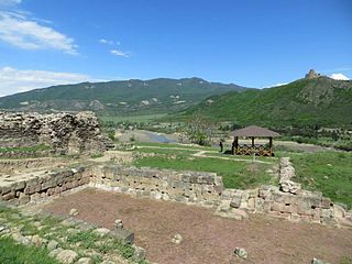
Armazi is a locale in Georgia, 4 km southwest of Mtskheta and 22 km northwest of Tbilisi. A part of historical Greater Mtskheta, it is a place where the ancient city of the same name and the original capital of the early Georgian kingdom of Kartli or Iberia was located. It particularly flourished in the early centuries AD and was destroyed by the Arab invasion in the 730s.

Mtskheta is a district of Georgia, in the region of Mtskheta-Mtianeti. Its main town is Mtskheta. Population of Mtskheta Municipality - 47 711 inhabitants. The municipality includes one city (Mtskheta) and 63 settlements. The city is the municipal center of Mtskheta and its population is 7,940 inhabitants or 13% of the population of the municipality. The largest village is Mukhrani with 6,197 inhabitants.
Saguramo Range is an east-west mountain range in Eastern Georgia located immediately to the north of the city of Tbilisi. The highest mountain of the range is Mt. Saguramo at an elevation of 1,392 meters (4,567 ft.) above sea level. The Saguramo Range forms the western extension of the Ialno Range. The geologic makeup of the mountains consists of neogene sandstone, clay and conglomerates. The area lies in a moderately humid subtropical zone and the slopes of the Saguramo Range are mainly covered by deciduous forests consisting of hornbeam, oak, and maple at lower elevations with beech taking over at higher elevations. The understory layer also includes evergreen elements characteristic of Colchian forests.

The Georgian S9 route, also known as Tbilisi Bypass, is a "road of international importance" within the Georgian road network with a length of 49 kilometres (30 mi) and runs in a wide curve around the East side of Tbilisi between the S1 Highway near Mtskheta) to the S4 Highway near Rustavi. The bypass intersects with the S5 "Kakheti Highway" near the Tbilisi International Airport and is part of the European E60 and Asian AH5 and AH81 routes. Transit traffic is mandated to take the bypass around Tbilisi.

The Tusheti National Park in eastern Georgia is one of the eight new protected areas approved by Parliament of Georgia on 22 April 2003.

Natakhtari Airfield is a domestic airport located in Natakhtari, Mtskheta-Mtianeti, Georgia. It serves as a secondary and domestic-only airfield for the Tbilisi metropolitan area at roughly 20 kilometres (12 mi) north of the city. It is privately owned and operated by the parent company of Vanilla Sky Airlines, Service Air. The airfield operates a bus link with Tbilisi in connection with scheduled flights.

Pshav-Khevsureti National Park is in Dusheti Municipality, Mtskheta-Mtianeti region of Georgia. Park has been established by direct involvement of World Wide Fund for Nature.

Nedzvi Managed Reserve is a protected area in central Georgia, in Samtskhe-Javakheti situated in the Lesser Caucasus, southwest to the nation's capital of Tbilisi in Borjomi Municipality. Nedzvi Managed Reserve along with Borjomi Strict Nature Reserve, Borjomi-Kharagauli National Park and Goderdzi Petrified Forest Natural Monument is one of four protected areas under same management authority. The accurate size and borders of the protected areas has yet to be determined. Its ecoregion is that of the Caucasus mixed forests.

Gardabani Managed Reserve is a protected area in Gardabani Municipality and Marneuli Municipality in Kvemo Kartli region of Georgia. Reserve is located on the left bank of Mtkvari river near the Azerbaijan border at a distance of 39 km from Tbilisi. It protects floodplain forest groves as well as local fauna. It has been considered to be included into Ramsar Convention list of Wetlands of international importance. Gardabani Managed Reserve is part of the Georgian protected areas system which also includes Tbilisi National Park, Saguramo Range, Gldani, Martqopi, Gulele.
FC Mtskheta, renamed to Mtskheta-Urioni in the 2003–04 season, was a Georgian association football club based in Mtskheta.