
Merthyr Tydfil is the main town in Merthyr Tydfil County Borough, Wales, administered by Merthyr Tydfil County Borough Council. It is about 23 miles (37 km) north of Cardiff. Often called just Merthyr, it is said to be named after Tydfil, daughter of King Brychan of Brycheiniog, who according to legend was slain at Merthyr by pagans about 480 CE. Merthyr generally means "martyr" in modern Welsh, but here closer to the Latin martyrium: a place of worship built over a martyr's relics. Similar place names in south Wales are Merthyr Cynog, Merthyr Dyfan and Merthyr Mawr.

The Glamorganshire Canal in South Wales, UK, was begun in 1790. It ran along the valley of the River Taff from Merthyr Tydfil to the Bristol Channel at Cardiff. The final section of canal was closed in 1951.

The Taff Trail is a walking and cycle path that runs for 55 miles (89 km) between Cardiff Bay and Brecon in Wales. It is so named because it follows the course of the River Taff. Along much of its length, it follows the National Cycle Network Route 8 that continues to Holyhead, and is substantially off-road.

The River Taff is a river in Wales. It rises in the Brecon Beacons as two rivers, the Taf Fechan and the Taf Fawr before becoming one just north of Merthyr Tydfil. At Cardiff, it empties into the Bristol Channel.
The Rhymney Railway (RR) was a railway company in South Wales, founded to transport minerals and materials to and from collieries and ironworks in the Rhymney Valley of South Wales, and to docks in Cardiff. It opened a main line in 1858, and a limited passenger service was operated in addition.

Abercynon is a village and community in the Cynon Valley within the unitary authority of Rhondda Cynon Taf, Wales. The community comprises the village and the districts of Carnetown and Grovers Field to the south, Navigation Park to the east, and Glancynon to the north.
The Cyfarthfa Ironworks were major 18th- and 19th-century ironworks in Cyfarthfa, on the north-western edge of Merthyr Tydfil, in South West Wales.

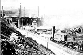
The Dowlais Ironworks was a major ironworks and steelworks located at Dowlais near Merthyr Tydfil, in Wales. Founded in the 18th century, it operated until the end of the 20th, at one time in the 19th century being the largest steel producer in the UK. Dowlais Ironworks was the first business to license the Bessemer process, using it to produce steel in 1865. Dowlais Ironworks was one of the four principal ironworks in Merthyr. The other three were Cyfarthfa, Plymouth, and Penydarren Ironworks. In 1936 Dowlais played a part in the events leading to the abdication crisis of Edward VIII, when the King visited the steelworks and was reported as saying that "these works brought these men here. Something must be done to get them back to work", a statement which was seen as political interference. The steelworks closed in 1987.
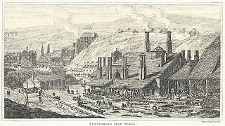
Penydarren Ironworks was the fourth of the great ironworks established at Merthyr Tydfil in South Wales.

Pontygwaith is a village in the Taff Valley, 9 km south of Merthyr Tydfil in Wales.
Charles Wood was an English ironmaster and one of the inventors of the potting and stamping method of making wrought iron from pig iron.

Pont-y-gwaith is a historical bridge over the River Taff near Edwardsville, Merthyr Tydfil, Wales.
Penydarren is a community and electoral ward in Merthyr Tydfil County Borough in Wales.

The Pont-y-Cafnau, is a 14.2-metre (47 ft) long iron truss bridge over the River Taff in Merthyr Tydfil, Wales. The bridge was designed by Watkin George and built in 1793 for his employer, the Cyfarthfa Ironworks, to support both a tramway and an aqueduct to carry limestone and water into the works. A Grade II* listed building and Scheduled Ancient Monument, the Pont-y-Cafnau is the world's earliest surviving iron railway bridge.

Cefn-coed-y-cymmer is a small community on the northwestern edge of Merthyr Tydfil County Borough in Wales. It is situated in the neck of land between the rivers Taf Fawr and Taf Fechan at their confluence. The village lies within the community of Vaynor. Immediately to the north of the village is the hill of Cefn Cil Sanws on the southern slopes of which is Merthyr Tydfil Golf Club. The village is bounded both to the north and the west by the Brecon Beacons National Park.

The Merthyr Tramroad was a 9.75-mile-long (15.69 km) line that opened in 1802, connecting the private lines belonging to the Dowlais and Penydarren Ironworks with the Glamorganshire Canal at Abercynon, also serving the Plymouth Ironworks along the way. It is famous as the line, on which Richard Trevithick's experimental locomotive hauled the first train to carry a load. It was largely superseded when the Taff Vale Railway opened in 1841, and sections gradually went out of use over two decades, from about 1851.

Merthyr Tydfil County Borough is a county borough in the south-east of Wales. In 2022, it had an estimated population of 58,883, making it the smallest local authority in Wales by population. It is located in the historic county of Glamorgan and takes its name from the town with the same name. The county borough consists of the northern part of the Taff Valley and the smaller neighbouring Taff Bargoed Valley. It borders the counties of Rhondda Cynon Taf to the west, Caerphilly County Borough to the east, and Powys to the north.
Watkin George (1759-1822) was an carpenter, engineer and ironmaster from Trevethin in Monmouthshire. He rose from humble beginnings as a carpenter to have a major influence on ironworks at Cyfartha and Pontypool and is responsible for the design of early cast-iron bridges.

The Treforest tinplate works in Treforest, Wales, operated between the late 18th century and 1939. The six remaining buildings on the site were constructed in the mid 19th century during which time the iron and tinplate industries were dominated by South Wales. These buildings form the best surviving group of tinplate manufacturing buildings in the region and are Grade II* listed.
The Industrial Revolution in Wales was the adoption and developments of new technologies in Wales in the 18th and 19th centuries as part of the Industrial Revolution, resulting in increases in the scale of industry in Wales.
