Old Quarrington

Last updated

Old Quarrington is a hamlet in County Durham, in England. It is situated between Bowburn and Quarrington Hill. It is also known locally as Heugh Hall, which was the name of a local colliery. [1]

County Durham County of England

County Durham is a county in North East England. The county town is Durham, a cathedral city. The largest settlement is Darlington, closely followed by Hartlepool and Stockton-on-Tees. It borders Tyne and Wear to the north east, Northumberland to the north, Cumbria to the west and North Yorkshire to the south. The county's historic boundaries stretch between the rivers Tyne and Tees, thus including places such as Gateshead, Jarrow, South Shields and Sunderland.

England Country in north-west Europe, part of the United Kingdom

England is a country that is part of the United Kingdom. It shares land borders with Wales to the west and Scotland to the north-northwest. The Irish Sea lies west of England and the Celtic Sea lies to the southwest. England is separated from continental Europe by the North Sea to the east and the English Channel to the south. The country covers five-eighths of the island of Great Britain, which lies in the North Atlantic, and includes over 100 smaller islands, such as the Isles of Scilly and the Isle of Wight.

Bowburn village in United Kingdom

Bowburn is a village in County Durham, England. It is situated about 3 miles (4.8 km) to the south-east of Durham, on the A177, between Coxhoe to the south-east, and High Shincliffe to the north-west.

In the Middle Ages, Old Quarrington was the centre of a district of County Durham called “Queringdonshire" (Quarringtonshire), which contained nearby Sherburn, Shadforth, Cassop, Tursdale and Whitwell House. [1]

Sherburn, County Durham village in United Kingdom

Sherburn Village it is part of the unitary authority of County Durham lying 3.5 miles east of Durham in the north east of England. It is one of the "green villages" of County Durham.

Shadforth village in United Kingdom

Shadforth is a village in County Durham, England. It is situated a few miles to the east of Durham. The historic centre of the village is designated a conservation area. The population of the civil parish taken at the 2011 census was 2118.

Cassop village in United Kingdom

Cassop is a village in County Durham, in England. It has a population of about 500 and is located near the city of Durham. A former mining village, mining is no longer the main occupation of Cassop's inhabitants due to extensive mine closure over the last 30 years.

Related Research Articles

Durham District former non-metropolitan district in Durham, England

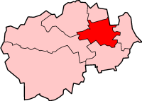
The City of Durham was, from 1974 to 2009, a non-metropolitan district of County Durham in North East England, with the status of borough and city.

West Hartlepool western part of the borough of Hartlepool in North East England

West Hartlepool refers to the western part of what has since the 1960s been known as the borough of Hartlepool in North East England. It was originally formed in 1854 as the result of the opening of seaside docks and railways that connected the docks to cities to the east and west.

Brancepeth village in United Kingdom

Brancepeth is a village and civil parish in County Durham, in England. It is situated about 8 km (5.0 mi) from Durham on the A690 road between Durham and Weardale. The population of the civil parish taken at the 2011 census was 414.

Staindrop village in United Kingdom

Staindrop is a village and civil parish east of Barnard Castle in County Durham, England. The population at the 2011 census was 1,310.

Dalton-le-Dale village in United Kingdom

Dalton-le-Dale is a small village in County Durham, in England. The parish population taken at the 2011 census was 1,546. It is situated on the old A19 road between Seaham and Murton. Most of the village is located in a wooded valley bottom, stradling a single road which follows the stream that runs through what is left of Cold Hesledon Dene. Where the road rises to meet the original path of the old A19, there is a small but very fine medieval church which is hidden form the old A19 in a dip. In the opposite direction where the village road to Seaham crosses the stream is Dalton Tower.

Quarrington Hill is a village in County Durham, in England. It is situated a short distance to the north of Kelloe.

Old Cassop is a hamlet in County Durham, in England. It is situated a few miles to the south-east of Durham. Old Cassop lies within the Cassop-cum-Quarrington civil parish.

Tursdale is a hamlet in County Durham, England. It is situated in rural landscape about two miles to the west of Coxhoe, two miles North of Cornforth and around five miles south of Durham. It is part of the civil parish of Cassop-cum-Quarrington. It is ideally located for speedy access to both Durham city, the A1M, and Teesside via Sedgefield. Despite its close proximity to many local amenities and towns, residents enjoy the peaceful lifestyle of living in a semi-rural location, with lovely views across the fields.

Mordon village in United Kingdom

Mordon is a village in County Durham, England. It is situated a few miles to the north-east of Newton Aycliffe. The population recorded by the 2011 census was 260.

Old Durham is a hamlet in County Durham, in England. It is situated approximately 1 mile east of central Durham and south of Gilesgate.

Cassop-cum-Quarrington is a civil parish in County Durham, England. According to the 2001 census it had a population of 4,735, increasing to 5,219 at the 2011 census.

Quarrington may refer to:

A688 road road in England

The A688 is a road in County Durham in North East England.

Durham Services

Durham Motorway Services are Located at junction 61 on the A1 (M). Located six miles from Durham City in between the villages of Bowburn and Coxhoe in County Durham. Opened in 1994 by David Bellamy.

Belmont Community School is a comprehensive school in Belmont, County Durham, England.

Cassop Vale

Cassop Vale is a Site of Special Scientific Interest in the Durham City district of County Durham, England. It lies between the villages of Bowburn and Cassop, 7 km south-east of the centre of Durham..

Quarrington Hill Grasslands

Quarrington Hill Grasslands is a Site of Special Scientific Interest in County Durham, England. The site consists of three separate areas, two closely adjacent to the east of the village of Quarrington Hill, the third immediately west of the village, which lies 8 km south-east of Durham City.

Quarrington, Lincolnshire human settlement in United Kingdom

Quarrington is a village and former civil parish, now part of the civil parish of Sleaford, in the North Kesteven district of Lincolnshire, a non-metropolitan county in the East Midlands of England. The old village and its church lie approximately 1.2 miles (2 km) south-west from the centre of Sleaford, the nearest market town, but suburban housing developments at New Quarrington and Quarrington Hill effectively link the two settlements. Bypassed by the A15, it is connected to Lincoln and Peterborough, as well as Newark and King's Lynn. At the 2011 Census, Quarrington and Mareham ward, which incorporates most of the settlement, had an estimated population of 7,046.

References

  1. 1 2 "A short history of Bowburn". www.bowburnhistory.co.uk. Bowburn Local History Society. Retrieved 15 October 2016.

Commons-logo.svg Media related to Old Quarrington at Wikimedia Commons

Coordinates: 54°44′04″N1°29′57″W / 54.73433°N 1.49921°W / 54.73433; -1.49921

Geographic coordinate system Coordinate system

A geographic coordinate system is a coordinate system that enables every location on Earth to be specified by a set of numbers, letters or symbols. The coordinates are often chosen such that one of the numbers represents a vertical position and two or three of the numbers represent a horizontal position; alternatively, a geographic position may be expressed in a combined three-dimensional Cartesian vector. A common choice of coordinates is latitude, longitude and elevation. To specify a location on a plane requires a map projection.