Old Town Hall, Liversedge

Last updated

Old Town Hall
Liversedge Sparrow Park.jpg
Old Town Hall, Liversedge
LocationKnowler Hill, Liversedge
Coordinates 53°42′39″N1°41′55″W / 53.7109°N 1.6986°W / 53.7109; -1.6986 Coordinates: 53°42′39″N1°41′55″W / 53.7109°N 1.6986°W / 53.7109; -1.6986
Builtc.1880
ArchitectWilliam Ellis
Architectural style(s) Italianate style
West Yorkshire UK location map.svg
Red pog.svg
Shown in West Yorkshire

The Old Town Hall is a former municipal building in Knowler Hill in Liversedge, West Yorkshire, England. The building, which formerly operated as the offices of Liversedge Urban District Council, is now used as private residential accommodation.

History

Following significant population growth, largely associated with the woollen industry, a local board of health was established in the Liversedge area in 1875. [1] The main reason for the formation of the board was to establish proper drainage in the township, [2] but a second order priority was to commission offices for the board itself: the site they selected for the new building was open land at the top of Knowler Hill. [3]

The building was designed by William Ellis of Heckmondwike in the Italianate style, built in limestone brick and was completed in around 1880. [4] The design involved a symmetrical main frontage with three bays facing onto Knowler Hill. The central bay featured a doorway with a fanlight, an archivolt and a keystone which was flanked by pilasters supporting a cornice; the pilasters were decorated with carved floral bosses. On the first floor, the central bay was fenestrated by a pair of round headed windows and the other bays were fenestrated in a similar style. At roof level there was a heavily bracketed cornice. Internally, the principal room was the boardroom for the local board. [4]

The local board was replaced by Liversedge Urban District Council, with its headquarters in the former public offices, in 1894. [5] The building became known as the "Town Hall" in the late 19th century and continued to serve as the headquarters of the urban district council into the early 20th century, [6] but ceased to be the local seat of government when the enlarged Spenborough Urban District Council was formed in Cleckheaton in 1915. [5] The building, by then known as the "Old Town Hall", was subsequently used as a community centre and a clinic with visiting medical staff. [7] After the Second World War, it was converted for commercial use and served as an electrical store, known as "Padgett's Radio Stores", in the 1960s and 1970s, before being converted into private residential accommodation. [8] [9]

The significance of the building was recognised when, in 2012, a garden known as "Sparrow Park" was constructed outside the building in commemoration of the 200th anniversary of the uprising and Luddite attack on Rawfolds Mill, which began just up the road from the monument in the still-operational "Shears" public house. [10] [11] [12]

Related Research Articles

<span class="mw-page-title-main">Cleckheaton</span> Town in West Yorkshire, England

Cleckheaton is a town in the Metropolitan borough of Kirklees, in West Yorkshire, England. Historically part of the West Riding of Yorkshire, it is situated south of Bradford, east of Brighouse, west of Batley and south-west of Leeds. It is at the centre of the Spen Valley and was the major town in the former borough of Spenborough. Cleckheaton has a history as a mill town and forms part of the Heavy Woollen District.

<span class="mw-page-title-main">Heckmondwike</span> Town in West Yorkshire, England

Heckmondwike is a town in the metropolitan borough of Kirklees, West Yorkshire, England, 9 miles (14 km) south west of Leeds. Historically part of the West Riding of Yorkshire, it is close to Cleckheaton and Liversedge. It is mostly in the Batley and Spen parliamentary constituency, and had an estimated population of 17,066 in March 2001, reducing to 16,986 at the 2011 Census. Heckmondwike forms part of the Heavy Woollen District.

<span class="mw-page-title-main">Inveraray Jail</span> Council headquarters in Inveraray, Scotland

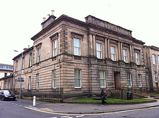
Inveraray Jail, formerly County Buildings, is a municipal structure in Church Square, Inveraray, Argyll and Bute, Scotland. The structure, which was the headquarters of Argyll County Council as well as a jail and a courthouse, is a Category A listed building.

<span class="mw-page-title-main">Liversedge</span> Town in West Yorkshire, England

Liversedge is a town and former parish of Birstall, in the metropolitan borough of Kirklees, West Yorkshire, England. Historically part of the West Riding of Yorkshire, Liversedge lies between Cleckheaton and Heckmondwike. The Kirklees ward is now called Liversedge and Gomersal with a population at the 2011 Census of 19,420. Liversedge forms part of the Heavy Woollen District.

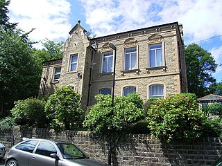
Spenborough was, from 1915 to 1974, a local government district in the administrative county of Yorkshire, West Riding, England.

<span class="mw-page-title-main">Knottingley Town Hall</span> Municipal building in Knottingley, West Yorkshire, England

Knottingley Town Hall is a municipal building in Weeland Road, Knottingley, West Yorkshire, England. The structure, which served as the headquarters of Knottingley Urban District Council, now operates as a community centre.

<span class="mw-page-title-main">Otley Civic Centre</span> Municipal building in Otley, West Yorkshire, England

Otley Civic Centre is a municipal structure in Cross Green, Otley, West Yorkshire, England. The structure, which was the offices and meeting place of Otley Town Council, is a Grade II listed building.

<span class="mw-page-title-main">Guiseley Theatre</span> Municipal building in Guiseley, West Yorkshire, England

Guiseley Theatre, formerly Guiseley Town Hall, is a municipal building at The Green, Guiseley, West Yorkshire, England. The structure, which was once the headquarters of Guiseley Urban District Council, is now a theatre.

<span class="mw-page-title-main">Long Eaton Town Hall</span> Municipal building in Long Eaton, Derbyshire, England

Long Eaton Town Hall is a municipal building in Derby Road, Long Eaton, Derbyshire, England. The town hall, which currently serves as one of two meeting places of Erewash Borough Council, is a Grade II* listed building.

<span class="mw-page-title-main">Ashby-de-la-Zouch Town Hall</span> Municipal building in Ashby-de-la-Zouch, Leicestershire, England

Ashby-de-la-Zouch Town Hall is a municipal building in Market Street in Ashby-de-la-Zouch, Leicestershire, England. The structure, which was used as the offices of Ashby-de-la-Zouch Urban District Council, is a Grade II listed building. The market hall, which is located behind the town hall, is separately listed.

<span class="mw-page-title-main">Stokesley Town Hall</span> Municipal building in Stokesley, North Yorkshire, England

Stokesley Town Hall is a municipal building in the Market Place in Stokesley, North Yorkshire, England. The structure, which accommodates the offices and meeting place of Stokesley Town Council, is a grade II listed building.

<span class="mw-page-title-main">Beeston Town Hall</span> Municipal building in Beeston, Nottinghamshire, England

Beeston Town Hall is a municipal building in Foster Avenue in Beeston, Nottinghamshire, England. The building was formerly the offices of Beeston and Stapleford Urban District Council and is now used by the Redeemer Church.

<span class="mw-page-title-main">Meltham Town Hall</span> Municipal building in Cottingley, West Yorkshire, England

Meltham Town Hall is a municipal building in Carlile Street in Meltham, West Yorkshire, England. The building, which formerly operated as the offices of Meltham Urban District Council, is now The Crossroads Centre, which operates the local foodbank.

<span class="mw-page-title-main">Old Town Hall, Slaithwaite</span> Municipal building in Slaithwaite, West Yorkshire, England

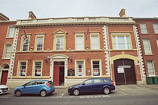
The Old Town Hall, also known as Empire House, is a former municipal building in Lewisham Road in Slaithwaite, West Yorkshire, England. The building, which served as the offices of Colne Valley Urban District Council, is now a business centre.

<span class="mw-page-title-main">Old Town Hall, Lisburn</span> Municipal Building in Lisburn, Northern Ireland

The Old Town Hall is a municipal structure in Castle Street, Lisburn, County Antrim, Northern Ireland. The structure, which is used as a constituency office by the Democratic Unionist Party, is a Grade B2 listed building.

<span class="mw-page-title-main">Woking Civic Offices</span> Municipal building in Woking, England

Woking Civic Offices is a municipal building in Gloucester Walk, Woking, Surrey, England. It is in use as the headquarters of Woking Borough Council.

<span class="mw-page-title-main">Coldstream Town Hall</span> Municipal building in Coldstream, Scotland

Coldstream Town Hall is a municipal building in the High Street, Coldstream, Scottish Borders, Scotland. The structure, which currently accommodates a library and a registration office, is a Category B listed building.

<span class="mw-page-title-main">Elgin Sheriff Court</span> Courthouse in Elgin, Scotland

Elgin Sheriff Court is a municipal structure in the High Street, Elgin, Moray, Scotland. The structure, which was the headquarters of Morayshire County Council and remains in use as a courthouse, is a Category B listed building.

<span class="mw-page-title-main">Paisley Sheriff Court</span> Courthouse in Paisley, Scotland

Paisley Sheriff Court is a municipal structure in St James Street, Paisley, Renfrewshire, Scotland. The complex, which was the headquarters of Renfrewshire County Council and is currently used as a courthouse, is a Category A listed building.

<span class="mw-page-title-main">Dumbarton Sheriff Court</span> Courthouse in Dumbarton, Scotland

Dumbarton Sheriff Court is a judicial structure in Church Street, Dumbarton, West Dunbartonshire, Scotland. The complex, which was the headquarters of Dunbartonshire County Council and is currently used as a courthouse, is a Category B listed building.

References

  1. "Liversedge Local Board and UDC". National Archives. Retrieved 8 May 2022.
  2. Peel, Frank (1893). Spen Valley, Past and Present. Senior and Company. p. 380.
  3. "Ordnance Survey Map". 1888. Retrieved 7 May 2022.
  4. 1 2 "Tenders". The Leeds Mercury. 21 November 1878. Retrieved 7 May 2022. The erection of public offices, house, stabling, outbuildings, and boundary walls, at Hightown, Liversedge for the Liversedge Local Board. Plans and specifications may be seen, and bills of quantities obtained, at the offices of Mr. William Ellis, Architect, Heckmondwike, from the 23rd to 30th instant, both inclusive.
  5. 1 2 "Liversedge UD". Vision of Britain. Retrieved 7 May 2022.
  6. "No. 27137". The London Gazette . 21 November 1899. p. 7345.
  7. "Fiftieth Annual report of the County Medical Officer for the tear 1938". County Council of the West Riding Of Yorkshire. Retrieved 7 May 2022.
  8. "Padgett's Radio Stores" (PDF). Practical Television. 1 September 1964. p. 548.
  9. "Padgett's Radio Stores". Vol. 73. Wireless World. 1973. p. 127.
  10. "Civic society aims to create park". Yorkshire Post. 27 February 2011. Retrieved 7 May 2022.
  11. "Memorial to Luddites to be unveiled in Liversedge". Telegraph and Argus. 25 March 2012. Retrieved 7 May 2022.
  12. "Liversedge Luddite pub The Shears saved from demolition". BBC. 25 April 2021. Retrieved 7 May 2022.