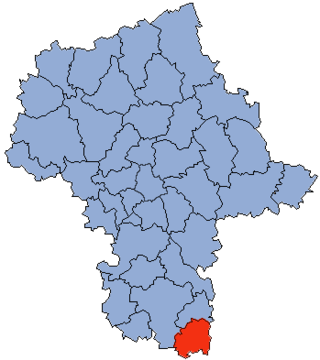
Lipsko County is a unit of territorial administration and local government (powiat) in Masovian Voivodeship, east-central Poland. It came into being on January 1, 1999, as a result of the Polish local government reforms passed in 1998. Its administrative seat is Lipsko, which lies 127 kilometres (79 mi) south of Warsaw. The only other town in this county is Solec nad Wisłą.

Puławy County is a unit of territorial administration and local government (powiat) in Lublin Voivodeship, eastern Poland. It was first established in 1867, but its current borders were established on January 1, 1999, as a result of the Polish local government reforms passed in 1998. Its administrative seat and largest town is Puławy, which lies 46 kilometres (29 mi) north-west of the regional capital Lublin. The county also contains the towns of Nałęczów, lying 23 km (14 mi) south-east of Puławy, and Kazimierz Dolny, 11 km (7 mi) south of Puławy.

Biłgoraj County is a unit of territorial administration and local government (powiat) in Lublin Voivodeship, eastern Poland. It was established on January 1, 1999, as a result of the Polish local government reforms passed in 1998. Its administrative seat and largest town is Biłgoraj, which lies 79 kilometres (49 mi) south of the regional capital Lublin. The county contains three other towns: Tarnogród, lying 21 km (13 mi) south of Biłgoraj, Józefów, lying 24 km (15 mi) east of Biłgoraj, and Frampol, 16 km (10 mi) north of Biłgoraj.

Lubartów County is a unit of territorial administration and local government (powiat) in Lublin Voivodeship, eastern Poland. It was established on January 1, 1999, as a result of the Polish local government reforms passed in 1998. Its administrative seat and largest town is Lubartów, which lies 25 kilometres (16 mi) north of the regional capital Lublin. The county also contains the towns of Kock, lying 23 km (14 mi) north-west of Lubartów, and Ostrów Lubelski, 18 km (11 mi) east of Lubartów.

Lublin County is a unit of territorial administration and local government (powiat) in Lublin Voivodeship, eastern Poland. It was established on January 1, 1999, as a result of the Polish local government reforms passed in 1998. Its administrative seat is the city of Lublin, although the city is not part of the county. The only towns in Lublin County are Bełżyce, which lies 23 km (14 mi) west of Lublin, and Bychawa, 26 km (16 mi) south of Lublin.

Kraśnik County is a unit of territorial administration and local government (powiat) in Lublin Voivodeship, eastern Poland. It was established on January 1, 1999, as a result of the Polish local government reforms passed in 1998. Its administrative seat and largest town is Kraśnik, which lies 45 kilometres (28 mi) south-west of the regional capital Lublin. The only other town in the county is Annopol, lying 25 km (16 mi) west of Kraśnik.

Tomaszów County is a unit of territorial administration and local government (powiat) in Lublin Voivodeship, eastern Poland, on the border with Ukraine. It was established on January 1, 1999, as a result of the Polish local government reforms passed in 1998. Its administrative seat and largest town is Tomaszów Lubelski, which lies 107 kilometres (66 mi) south-east of the regional capital Lublin. The only other towns in the county are Tyszowce, lying 28 km (17 mi) north-east of Tomaszów, and Łaszczów, lying 25 km (16 mi) east of Tomaszów.

Zwoleń County is a unit of territorial administration and local government (powiat) in Masovian Voivodeship, east-central Poland. It came into being on January 1, 1999, as a result of the Polish local government reforms passed in 1998. Its administrative seat and only town is Zwoleń, which lies 104 kilometres (65 mi) south-east of Warsaw.

Opatów County is a unit of territorial administration and local government (powiat) in Świętokrzyskie Voivodeship, south-central Poland. It came into being on January 1, 1999, as a result of the Polish local government reforms passed in 1998. Its administrative seat and largest town is Opatów, which lies 58 kilometres (36 mi) east of the regional capital Kielce. The only other town in the county is Ożarów, lying 20 km (12 mi) north-east of Opatów.

Krapkowice County is a unit of territorial administration and local government (powiat) in Opole Voivodeship, south-western Poland. It came into being on January 1, 1999, as a result of the Polish local government reforms passed in 1998. Its administrative seat and largest town is Krapkowice, which lies 23 kilometres (14 mi) south of the regional capital Opole. The county also contains the towns of Zdzieszowice, lying 13 km (8 mi) south-east of Krapkowice, and Gogolin, 5 km (3 mi) north-east of Krapkowice.

Kluczbork County is a unit of territorial administration and local government (powiat) in Opole Voivodeship, south-western Poland. It came into being on January 1, 1999, as a result of the Polish local government reforms passed in 1998. Its administrative seat and largest town is Kluczbork, which lies 41 kilometres (25 mi) north-east of the regional capital Opole. The county also contains the towns of Wołczyn, lying 12 km (7 mi) west of Kluczbork, and Byczyna, 15 km (9 mi) north of Kluczbork.

Nysa County is a unit of territorial administration and local government (powiat) in Opole Voivodeship, south-western Poland, on the Czech border. It came into being on January 1, 1999, as a result of the Polish local government reforms passed in 1998. Its administrative seat and largest town is Nysa, which lies 48 kilometres (30 mi) south-west of the regional capital Opole. The county contains four other towns: Głuchołazy, 18 km (11 mi) south of Nysa, Paczków, 24 km (15 mi) west of Nysa, Otmuchów, 12 km (7 mi) west of Nysa, and Korfantów, 20 km (12 mi) east of Nysa.

Prudnik County is a unit of territorial administration and local government (powiat) in Opole Voivodeship, south-western Poland, on the Czech border. It came into being on January 1, 1999, as a result of the Polish local government reforms passed in 1998. Its administrative seat and largest town is Prudnik, which lies 46 kilometres (29 mi) south-west of the regional capital Opole. The county also contains the towns of Głogówek, lying 21 km (13 mi) east of Prudnik, and Biała, 11 km (7 mi) north-east of Prudnik.

Namysłów County is a unit of territorial administration and local government (powiat) in Opole Voivodeship, south-western Poland. It came into being on January 1, 1999, as a result of the Polish local government reforms passed in 1998. Its administrative seat and only town is Namysłów, which lies 48 kilometres (30 mi) north of the regional capital, which is the city of Opole.

Strzelce County is a unit of territorial administration and local government (powiat) in Opole Voivodeship, south-western Poland. It came into being on January 1, 1999, as a result of the Polish local government reforms passed in 1998. Its administrative seat and largest town is Strzelce Opolskie, which lies 31 kilometres (19 mi) south-east of the regional capital Opole. The county contains four other towns: Zawadzkie, 19 km (12 mi) north-east of Strzelce Opolskie, Kolonowskie, 19 km (12 mi) north-east of Strzelce Opolskie, Leśnica, 11 km (7 mi) south-west of Strzelce Opolskie, and Ujazd, 14 km (9 mi) south-east of Strzelce Opolskie.

Brzeg County is a unit of territorial administration and local government (powiat) in Opole Voivodeship, south-western Poland. It came into being on January 1, 1999, as a result of the Polish local government reforms passed in 1998. Its administrative seat and largest town is Brzeg, which lies 39 kilometres (24 mi) north-west of the regional capital Opole. The county also contains the towns of Grodków, lying 22 km (14 mi) south of Brzeg, and Lewin Brzeski, 17 km (11 mi) south-east of Brzeg.
Gmina Chodel is a rural gmina in Opole Lubelskie County, Lublin Voivodeship, in eastern Poland. Its seat is the village of Chodel, which lies approximately 13 kilometres (8 mi) east of Opole Lubelskie and 35 km (22 mi) south-west of the regional capital Lublin.
Gmina Poniatowa is an urban-rural gmina in Opole Lubelskie County, Lublin Voivodeship, in eastern Poland. Its seat is the town of Poniatowa, which lies approximately 8 kilometres (5 mi) north-east of Opole Lubelskie and 36 km (22 mi) west of the regional capital Lublin.
Niezabitów is a village in the administrative district of Gmina Poniatowa, within Opole Lubelskie County, Lublin Voivodeship, in eastern Poland. It lies approximately 9 kilometres (6 mi) north-east of Poniatowa, 17 km (11 mi) north-east of Opole Lubelskie, and 31 km (19 mi) west of the regional capital Lublin.
Spławy is a village in the administrative district of Gmina Poniatowa, within Opole Lubelskie County, Lublin Voivodeship, in eastern Poland. It lies approximately 5 kilometres (3 mi) north-east of Poniatowa, 13 km (8 mi) north-east of Opole Lubelskie, and 34 km (21 mi) west of the regional capital Lublin.


