Oreamuno (canton)

Last updated
Oreamuno
Cot. Oreamuno. Cartago. Costa Rica.JPG
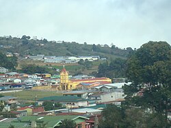
Cot town, in Oreamuno canton.
Bandera de Oreamuno (Costa Rica).svg
Escudo del Canton de Oreamuno.png
Oreamuno (canton)
Oreamuno canton
Costa Rica location map.svg
Red pog.svg
Oreamuno
Oreamuno canton location in Costa Rica
Coordinates: 9°59′50″N83°52′37″W / 9.9972861°N 83.8769838°W / 9.9972861; -83.8769838
Country Flag of Costa Rica.svg  Costa Rica
Province Cartago
Creation17 August 1914 [1]
Head city San Rafael
Districts
Government
  Type Municipality
  BodyMunicipalidad de Oreamuno
Area
  Total
202.31 km2 (78.11 sq mi)
Elevation
1,861 m (6,106 ft)
Population
 (2011)
  Total
45,473
  Density220/km2 (580/sq mi)
Time zone UTC−06:00
Canton code307
Website www.oreamuno.go.cr

Oreamuno is a canton in the Cartago province of Costa Rica. [2] [3] The head city is in San Rafael district.

Contents

History

Oreamuno was created on 17 August 1914 by decree 68. [1]

Geography

Oreamuno has an area of 202.31 km² [4] and a mean elevation of 1,861 metres. [2]

The canton extends from its suburban head city of San Rafael northward into the Cordillera Central (Central Mountain Range). Irazú Volcano looms large in the northern reaches of the canton.

Districts

The canton of Oreamuno is subdivided into the following districts:

  1. San Rafael
  2. Cot
  3. Potrero Cerrado
  4. Cipreses
  5. Santa Rosa

Demographics

Historical population
Census Pop.±% p.a.
19275,143    
19507,568+1.69%
196312,035+3.63%
197317,517+3.82%
198424,145+2.96%
200039,032+3.05%
201145,473+1.40%
202248,911+0.66%
Source: Instituto Nacional de Estadística y Censos [5]
Centro Centroamericano de Población [6]

For the 2011 census, Oreamuno had a population of 45,473 inhabitants. [7]

Transportation

Road transportation

The canton is covered by the following road routes:

Rail transportation

The Interurbano Line operated by Incofer goes through this canton.

References

  1. 1 2 Hernández, Hermógenes (1985). Costa Rica: evolución territorial y principales censos de población 1502 - 1984 (in Spanish) (1 ed.). San José: Editorial Universidad Estatal a Distancia. pp. 164–173. ISBN   9977-64-243-5. Archived from the original on 8 October 2020. Retrieved 5 October 2020.
  2. 1 2 "Declara oficial para efectos administrativos, la aprobación de la División Territorial Administrativa de la República N°41548-MGP". Sistema Costarricense de Información Jurídica (in Spanish). 19 March 2019. Retrieved 26 September 2020.
  3. División Territorial Administrativa de la República de Costa Rica (PDF) (in Spanish). Editorial Digital de la Imprenta Nacional. 8 March 2017. ISBN   978-9977-58-477-5.
  4. "Área en kilómetros cuadrados, según provincia, cantón y distrito administrativo". Instituto Nacional de Estadística y Censos (in Spanish). Archived from the original on 16 September 2020. Retrieved 26 September 2020.
  5. "Instituto Nacional de Estadística y Censos" (in Spanish).
  6. Centro Centroamericano de Población de la Universidad de Costa Rica. "Sistema de Consulta a Bases de Datos Estadísticas" (in Spanish).
  7. "Censo. 2011. Población total por zona y sexo, según provincia, cantón y distrito". Instituto Nacional de Estadística y Censos (in Spanish). Retrieved 26 September 2020.