Oregon (toponym)

Last updated

The origin of the name of the U.S. state of Oregon is unknown, [1] and a subject of some dispute.

U.S. state constituent political entity of the United States

In the United States, a state is a constituent political entity, of which there are currently 50. Bound together in a political union, each state holds governmental jurisdiction over a separate and defined geographic territory and shares its sovereignty with the federal government. Due to this shared sovereignty, Americans are citizens both of the federal republic and of the state in which they reside. State citizenship and residency are flexible, and no government approval is required to move between states, except for persons restricted by certain types of court orders. Four states use the term commonwealth rather than state in their full official names.

Oregon State of the United States of America

Oregon is a state in the Pacific Northwest region on the West Coast of the United States. The Columbia River delineates much of Oregon's northern boundary with Washington, while the Snake River delineates much of its eastern boundary with Idaho. The parallel 42° north delineates the southern boundary with California and Nevada. Oregon is one of only three states of the contiguous United States to have a coastline on the Pacific Ocean.

Contents

Historical usage

Most scholarship ascribes the earliest known use of the name "Oregon" to a 1765 petition by Major Robert Rogers to the Kingdom of Great Britain, seeking money to finance an expedition in search of the Northwest Passage. The petition read "the rout... is from the Great Lakes towards the Head of the Mississippi, and from thence to the River called by the Indians Ouragon...." [2] Thus, the early Oregon Country and now the present day state of Oregon took their names from the river now known as the Columbia River. [3]

Kingdom of Great Britain constitutional monarchy in Western Europe between 1707–1801

The Kingdom of Great Britain, officially called simply Great Britain, was a sovereign state in western Europe from 1 May 1707 to 31 December 1800. The state came into being following the Treaty of Union in 1706, ratified by the Acts of Union 1707, which united the kingdoms of England and Scotland to form a single kingdom encompassing the whole island of Great Britain and its outlying islands, with the exception of the Isle of Man and the Channel Islands. The unitary state was governed by a single parliament and government that was based in Westminster. The former kingdoms had been in personal union since James VI of Scotland became King of England and King of Ireland in 1603 following the death of Elizabeth I, bringing about the "Union of the Crowns". After the accession of George I to the throne of Great Britain in 1714, the kingdom was in a personal union with the Electorate of Hanover.

Northwest Passage sea route north of North America

The Northwest Passage (NWP) is, from the European and northern Atlantic point of view, the sea route to the Pacific Ocean through the Arctic Ocean, along the northern coast of North America via waterways through the Canadian Arctic Archipelago. The eastern route along the Arctic coasts of Norway and Siberia is accordingly called the Northeast Passage (NEP).

Oregon Country Early 19th century US fur trade district in North America

The Oregon Country was a predominantly American term referring to a disputed region of the Pacific Northwest of North America. The region was occupied by British and French Canadian fur traders from before 1810, and American settlers from the mid-1830s, with its coastal areas north from the Columbia River frequented by ships from all nations engaged in the maritime fur trade, most of these from the 1790s through 1810s being Boston-based. The Oregon Treaty of 1846 ended disputed joint occupancy pursuant to the Treaty of 1818 and established the British-American boundary at the 49th parallel.

In 1766, Rogers commissioned Jonathan Carver to lead such an expedition and in 1778, Carver used Oregon to label the Great River of the West in his book Travels Through the Interior Parts of North America. [4] The poet William Cullen Bryant took the name from Carver's book and used it in his poem Thanatopsis, published in 1817, to refer to the recent discoveries of the Lewis and Clark Expedition, which helped establish the name in modern use. [5]

Jonathan Carver American explorer

Jonathan Carver was a colonial American explorer and writer. He was born in Weymouth, Province of Massachusetts Bay and then moved with his family to Canterbury, Connecticut. He later married Abigail Robbins and became a shoemaker. He is believed to have had seven children.

William Cullen Bryant American romantic poet and journalist

William Cullen Bryant was an American romantic poet, journalist, and long-time editor of the New York Evening Post.

"Thanatopsis" is a poem by the American poet William Cullen Bryant. Meaning 'a consideration of death', the word is derived from the Greek 'thanatos' (death) and 'opsis'.

Other theories suggest that Rogers appropriated the Abenaki name for the Ohio River, Waregan, or found the name Ourican on a highly-speculative 1715 French map. [6]

The Abenaki are a Native American tribe and First Nation. They are one of the Algonquian-speaking peoples of northeastern North America. The Abenaki live in Quebec and the Maritimes of Canada and in the New England region of the United States, a region called Wabanahkik in the Eastern Algonquian languages. The Abenaki are one of the five members of the Wabanaki Confederacy.

Possible origins

Why Rogers used the name has led to many theories, which include these:

George R. Stewart American historian, toponymist, and novelist

George Rippey Stewart was an American historian, toponymist, novelist, and a professor of English at the University of California, Berkeley. His 1959 book, Pickett's Charge, a detailed history of the final attack at Gettysburg, was called "essential for an understanding of the Battle of Gettysburg". His 1949 post-apocalyptic novel Earth Abides won the first International Fantasy Award in 1951.

Wisconsin River river in Wisconsin, United States

The Wisconsin River is a tributary of the Mississippi River in the U.S. state of Wisconsin. At approximately 430 miles (692 km) long, it is the state's longest river. The river's name, first recorded in 1673 by Jacques Marquette as "Meskousing", is rooted in the Algonquian languages used by the area's American Indian tribes, but its original meaning is obscure. French explorers who followed in the wake of Marquette later modified the name to "Ouisconsin", and so it appears on Guillaume de L'Isle's map. This was simplified to "Wisconsin" in the early 19th century before being applied to Wisconsin Territory and finally the state of Wisconsin.

<i>Oregon Geographic Names</i> book by Lewis A. McArthur

Oregon Geographic Names is a compilation of the origin and meaning of place names in the U.S. state of Oregon, published by the Oregon Historical Society. The book was originally published in 1928. It was compiled and edited by Lewis A. McArthur. As of 2011, the book is in its seventh edition, which was compiled and edited by Lewis L. McArthur.

An abundance of beavers gave Oregon the nickname the Beaver State. Beaver.jpg
An abundance of beavers gave Oregon the nickname the Beaver State.
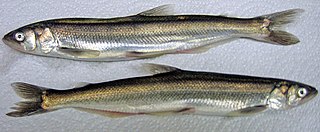
Eulachon species of fish

The eulachon, also called the candlefish, is a small anadromous ocean fish, a smelt found along the Pacific coast of North America from northern California to Alaska.

François Norbert Blanchet Catholic bishop

François Norbert Blanchet was a French Canadian-born missionary priest and prelate of the Roman Catholic Church who was instrumental in establishing the Catholic Church presence in the Pacific Northwest. He was one of the first Catholic priests to arrive in what was then known as the Oregon Country and subsequently became the first bishop and archbishop of the Archdiocese of Oregon City.

Others have speculated [16] that the name is related to the kingdom of Aragon: the major part of the Spanish soldiers who conquered the West Coast from California to Vancouver Island in the 18th century were in fact from Catalonia, a principality of the ancient Crown of Aragon in Spain. The name might also be derived from the Spanish last name Obregón, which in turn is related to a Spanish place name "Obregon" in Santander, Spain, on the north coast. [17]

See also

Related Research Articles

Lewis and Clark Expedition American overland expedition to the Pacific coast

The Lewis and Clark Expedition from May 1804 to September 1806, also known as the Corps of Discovery Expedition, was the first American expedition to cross the western portion of the United States. It began in Pittsburgh, Pa, made its way westward, and passed through the Continental Divide of the Americas to reach the Pacific coast. The Corps of Discovery was a selected group of US Army volunteers under the command of Captain Meriwether Lewis and his close friend Second Lieutenant William Clark.

The Territory of Washington was an organized incorporated territory of the United States that existed from March 2, 1853, until November 11, 1889, when the territory was admitted to the Union as the State of Washington. It was created from the portion of the Oregon Territory north of the lower Columbia River and north of the 46th parallel east of the Columbia. At its largest extent, it also included the entirety of modern Idaho and parts of Montana and Wyoming, before attaining its final boundaries in 1863.

Kalapuya

The Kalapuya are a Native American ethnic group, which had eight independent groups speaking three mutually unintelligible dialects. The Kalapuya tribes' traditional homelands were the Willamette Valley of present-day western Oregon in the United States, an area bounded by the Cascade Range to the east, the Oregon Coast Range at the west, the Columbia River at the north, to the Calapooya Mountains of the Umpqua River at the south.

Pocatello (Shoshone leader) Shoshone leader

Chief Pocatello was a leader of the Northern Shoshone, a Native American people of the Great Basin in western North America. He led attacks against early settlers during a time of increasing strife between settlers and Native Americans. After making peace with the U.S. Government, he moved his people to their present reservation in Idaho and led the Shoshone during their struggle to survive following their relocation. The city of Pocatello is named in his honor.

Rooster Rock State Park landform

Rooster Rock State Park is a state park located east of Corbett, in the U.S. state of Oregon. One of the features of the park is Rooster Rock, a column of basalt forming a natural obelisk, which stands near the south side of the Columbia River Gorge, in the lee of Crown Point. The park is administered by the Oregon Parks and Recreation Department.

Barlow Road historic road in Oregon

The Barlow Road is a historic road in what is now the U.S. state of Oregon. It was built in 1846 by Sam Barlow and Philip Foster, with authorization of the Provisional Legislature of Oregon, and served as the last overland segment of the Oregon Trail. Its construction allowed covered wagons to cross the Cascade Range and reach the Willamette Valley, which had previously been nearly impossible. Even so, it was by far the most harrowing 100 miles (160 km) of the nearly 2,000-mile (3,200 km) Oregon Trail.

Elliott Cutoff

The Elliott Cutoff was a covered wagon road that branched off the Oregon Trail at the Malheur River where present-day Vale, Oregon, United States is today. The first portion of the road was originally known as the Meek Cutoff after Stephen Meek, a former trapper who led over 1,000 emigrants into the Harney Basin in 1845. There were considerable difficulties for the 1845 train, and after reaching a hill known as Wagontire, the people left Meek and split into groups. They turned north at the Deschutes River and finally returned to the traditional Oregon Trail near The Dalles.

Champoeg Meetings constituent assemblies of European settlers in the southern Oregon Country

The Champoeg Meetings were the first attempts at formal governance by European-American and French Canadian pioneers in the Oregon Country on the Pacific Northwest coast of North America. Between 1841 and 1843, a series of public councils was held at Champoeg, a settlement on the French Prairie of the Willamette River valley in present-day Marion County, Oregon, and at surrounding settlements. The meetings were organized by newly arrived settlers as well as Protestant missionaries from the Methodist Mission and Catholic Jesuit priests from Canada.

History of Oregon history of the US state of Oregon

The history of Oregon, a U.S. state, may be considered in five eras: geologic history, inhabitation by native peoples, early exploration by Europeans, settlement by pioneers, and modern development.

Sinclair Pass

Sinclair Pass is a high mountain pass in Kootenay National Park between the Columbia and Kootenay Rivers to the northeast of present-day Radium Hot Springs in the province of British Columbia, Canada.

Antoine-Simon Le Page du Pratz (1695?–1775) was an ethnographer, historian, and naturalist who is best known for his Histoire de la Louisiane. It was first published in twelve installments from 1751–1753 in the Journal Economique, then completely in three volumes in Paris in 1758. After their victory in the Seven Years' War, the English published part of it in translation in 1763. It has never been fully translated into English.

John West (captain) Scottish inventor and businessman, born 1809

John West was a Scottish inventor and businessman who emigrated to Canada, California and later Oregon where he operated a cannery and exported tuna to Great Britain.

Wyeth is an unincorporated community in Hood River County, Oregon, United States. It is the site of a campground area in the Columbia River Gorge National Scenic Area off Interstate 84 (I-84).

Morton M. McCarver American pioneer

"General" Morton Matthew McCarver was an American politician and pioneer in the West. A native of Kentucky, he helped found cities in Iowa, Oregon, and Washington while also involved in the early government of California. He served in the Provisional Legislature of Oregon, including as the first speaker of that body, and also fought in the Rogue River Wars.

Mount Sir Francis Drake mountain in Canada

Mount Sir Francis Drake, 2,705 metres (8,875 ft), is a mountain in the Pacific Ranges of British Columbia, Canada, standing above the south side of Waddington Harbour and the head of Bute Inlet on the Central Coast of British Columbia just south of the mouth of the Homathko River as it empties into that harbour and inlet.

This timeline of South Dakota is a list of events in the history of South Dakota by year.

References

  1. 1 2 Archbishop Blanchet (March 8, 1884). "Origin of the name Oregon" (PDF). Portland Oregonian. reprinted by the New York Times.
  2. Oregon Almanac
  3. Article on Oregon State in the Catholic Encyclopedia of 1910. Retrieved 10 March 2012
  4. Elliot, T.C. "Jonathan Carver's source for the name Oregon," in: Oregon Historical Quarterly, Vol. XXIII (1922), pp. 58-69
  5. Rees, p. 326
  6. Did this 1715 map influence the first appearance of the name Oregon? Geographicus.com.
  7. George R. Stewart (1944). "The Source of the Name 'Oregon'". American Speech. Duke University Press. 19 (2): 115–117. doi:10.2307/487012. JSTOR   487012.
  8. George R. Stewart (1967) [1945]. Names on the Land: A Historical Account of Place-Naming in the United States (Sentry edition (3rd) ed.). Houghton Mifflin. pp. 153, 463. ISBN   1-59017-273-6.
  9. Lewis A. McArthur; Lewis L. McArthur (2003) [1928]. Oregon Geographic Names (Seventh ed.). Portland, Oregon: Oregon Historical Society Press. ISBN   0-87595-277-1.
  10. Goddard and Love, par. 7
  11. Goddard and Love, par. 33
  12. Goddard and Love, pars. 34-41
  13. Rees, John E. (1 December 1920). "Oregon—Its Meaning, Origin and Application". The Quarterly of the Oregon Historical Society. 21: 319. Retrieved 2013-04-14. The word "Oregon" is derived from a Shoshoni Indian expression meaning, The River of the West, originating from the two Shoshoni words "Ogwa," River and "Pe-on," West, or "Ogwa Pe-on." The Sioux pronounced this word in the more euphonious manner in which their tongue excels and the Shoshoni "Gwa" underwent, etymologically, a variation in the new language and became changed to "r," thus giving the sonorous word which Jonathan Carver, who first published the name to the English world, heard spoken by them during his visit with the Sioux nation.[Boaz, Handbook of American Indian Languages, p. 875.]
  14. Elliott, T.C. (1921). "The Origin of the Name 'Oregon'". Oregon Historical Quarterly. by Oregon Historical Society: 91–115. Retrieved 2008-01-10.
  15. Scott, Harvey W. (1900). Not Marjoram: The Spanish Word "Oregano" Not the Original of Oregon . Oregon Historical Quarterly. 1. Oregon Historical Society. p. 165.|access-date= requires |url= (help)
  16. Galvani, W.H. "The early explorations and the origin of the name of the Oregon country," in: Oregon Historical Quarterly, Vol. XXI, No. 4 (Dec. 1920), pp. 332-340. Galvani tries to debunk the ascription to Carver and alleges an earlier use of the name on Spanish maps, citing one Gabriel Franchere.
  17. "Obregon Coat of Arms and History". House of Names. Retrieved 2012-07-08.

Further reading