
U.S. Route 101, or U.S. Highway 101 (US 101) is a north–south United States Numbered Highway that runs through the states of California, Oregon, and Washington, on the West Coast of the United States. It is also known as El Camino Real where its route along the southern and central California coast approximates the old trail which linked the Spanish missions, pueblos, and presidios. It merges at some points with California State Route 1 (SR 1).
U.S. Route 26 is an east–west United States highway. It started in Ogallala, Nebraska, and was subsequently extended to the West Coast in Oregon. When the U.S. highway system was first defined, it was limited to Nebraska and Wyoming; by the 1950s, it continued into Idaho and Oregon. The highway's eastern terminus is in Ogallala, Nebraska at an intersection with Interstate 80. Its western terminus is south of Seaside, Oregon at an intersection with U.S. Route 101. Prior to 2004, the route's last 20 miles (32 km) were co-signed with U.S. Route 101 from the highways' junction south of Seaside north to Astoria where its intersection with U.S. Route 30 was also U.S. 30's western terminus.
U.S. Route 97 is a major north–south United States highway in the western United States. It begins at a junction with Interstate 5 at Weed, California, and travels north, ending in Oroville in Okanogan County, Washington, at the Canada–US border, across from Osoyoos, British Columbia, becoming British Columbia Highway 97 upon entering Canada. Major cities that lie on US 97 include Klamath Falls, Bend, and Redmond in Oregon and Yakima, Ellensburg, and Wenatchee in Washington.

The Astoria–Megler Bridge is a steel cantilever through truss bridge in the northwest United States that spans the lower Columbia River, between Astoria, Oregon, and Point Ellice near Megler, Washington. Opened 53 years ago in 1966, it is the longest continuous truss bridge in North America.

Mist is an unincorporated community in Columbia County, Oregon, United States. Formerly called Riverside, the place was renamed in 1888 for the atmospheric conditions of the Nehalem Valley. The first land claims in the area had been made circa 1870. The original Riverside post office was closed in 1975.
Oregon Route 47 is an Oregon state highway that runs between the Willamette Valley, near McMinnville, and the city of Clatskanie, along the Columbia River in the northwest part of the state. OR 47 traverses several highways of the Oregon state highway system: part of the Tualatin Valley Highway No. 29, part of the Nehalem Highway No. 102, part of the Sunset Highway No. 47, and the Mist–Clatskanie Highway No. 110.

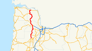
The Nehalem Highway No. 102 is a state highway in the U.S. state of Oregon that passes through the Nehalem River valley. It runs from U.S. Route 101 in Astoria southeast to Oregon Route 8 in Forest Grove. Between Astoria and the Mist-Clatskanie Highway in Mist, it is signed as Oregon Route 202; the rest is signed as Oregon Route 47. A piece at Astoria, north of the Warrenton-Astoria Highway, is also U.S. Route 101 Business.

Oregon Route 6 is a state highway in the U.S. state of Oregon that runs between the city of Tillamook on the Oregon Coast, to the Willamette Valley, near Banks. OR 6 traverses the Wilson River Highway No. 37 of the Oregon state highway system, named after the river paralleling the highway's western segment.

Oregon Route 103 is a 9.02-mile-long (14.52-kilometer) highway in the U.S. state of Oregon that runs between Jewell Junction and Jewell. It is also known as the Fishhawk Falls Highway No. 103, named after nearby Fishhawk Falls.

U.S. Route 101 (US 101), is a major north–south U.S. Highway in Oregon that runs through the state along the coastline near the Pacific Ocean. It runs from the California border, south of Brookings, to the Washington state line on the Columbia River, between Astoria, Oregon, and Megler, Washington.

In the U.S. state of Oregon, U.S. Route 30, a major east–west U.S. Highway, runs from its western terminus in Astoria to the Idaho border east of Ontario. West of Portland, US 30 generally follows the southern shore of the Columbia River; east of Portland the highway has largely been replaced with Interstate 84, though it is signed all the way across the state, and diverges from the I-84 mainline in several towns, as a de facto business route. Out of all the states U.S. Route 30 traverses, it spends the most time in Oregon.

Oregon Route 53 is an Oregon state highway that runs through a pair of river valleys in the Oregon Coast range; those of the Necanicum River and the Nehalem River. OR 53 traverses the Necanicum Highway No. 46 of the Oregon state highway system.
Jewell is an unincorporated community in Clatsop County, Oregon, United States. The logging community is located at the junction of Oregon Route 103 and Oregon Route 202, near the Nehalem River.
A total of fifteen special routes of U.S. Route 101 exist.
U.S. Route 101 (US 101) is a United States Numbered Highway that runs along the Pacific Coast from Los Angeles, California to Tumwater, Washington. Within the state of Washington, US 101 connects cities on the coast of the Pacific Ocean and encircles the Olympic Peninsula around the Olympic Mountains and Olympic National Park.

U.S. Route 26 (US-26) is a major cross-state United States highway with its western terminus in the U.S. state of Oregon, connecting U.S. Route 101 on the Oregon Coast near Seaside with the Idaho state line east of Nyssa. Local highway names include the Sunset Highway No. 47, Mount Hood Highway No. 26, and John Day Highway No. 5 before continuing into Idaho and beyond.

Birkenfeld is an unincorporated community in Columbia County, Oregon, United States, in the Nehalem Valley on Oregon Route 202 between Jewell and Mist.
Vesper is an unincorporated community in Clatsop County, Oregon, United States. The Nehalem River flows through the town. Settled in 1876 by William Johnston, a man who would be responsible for the town's first post office and church, Vesper borders Jewell and the Columbia County line. Johnston also served as the town's first postmaster. Before 1901, Vesper was completely isolated from the rest of the county on land; for one to reach the community, it would have been necessary to travel via ferry on the Nehalem River. The county expanded wagon roads to the community, eventually leading to automobile roads being built in 1908. Nowadays, Oregon Route 202 passes through Vesper.

State Route 102 (SR 102) is a 32.0-mile-long (51.5 km) state highway in the east-central part of the U.S. state of Georgia. The highway travels from Warthen northeast through Mitchell, east through Gibson, southeast to Avera, and arcing east to Wrens.

Juneta was passenger ferry that operated on the Nehalem River on the north coast of Oregon from 1910 to the mid-1920s. Thereafter this vessel was transferred to the Columbia River where it was operated out of Astoria as a cannery tender until the 1960s. Juneta was then converted to a tugboat, and operated commercially on the Columbia and Willamette rivers until 1976. Juneta is still in existence and afloat as a private yacht in the vicinity of Portland, Oregon.


