Interstate 5 (I-5) is the main north–south Interstate Highway on the West Coast of the United States, running largely parallel to the Pacific coast of the contiguous U.S. from Mexico to Canada. It travels through the states of California, Oregon, and Washington, serving several large cities on the U.S. West Coast, including San Diego, Los Angeles, Sacramento, Portland, and Seattle. It is the only continuous Interstate highway to touch both the Mexican and the Canadian borders. Upon crossing the Mexican border at its southern terminus, I-5 continues to Tijuana, Baja California, as Mexico Federal Highway 1 (Fed. 1). Upon crossing the Canadian border at its northern terminus, it continues to Vancouver as British Columbia Highway 99 (BC 99).
U.S. Route 26 is an east–west United States highway that started in Ogallala, Nebraska. Later, it was subsequently extended to the West Coast in Oregon. When the U.S. highway system was first defined, it was limited to Nebraska and Wyoming; by the 1950s, it continued into Idaho and Oregon. The highway's eastern terminus is in Ogallala, Nebraska at an intersection with Interstate 80. Its western terminus is south of Seaside, Oregon at an intersection with U.S. Route 101. Prior to 2004, the route's last 20 miles (32 km) were co-signed with U.S. Route 101 from the highways' junction south of Seaside north to Astoria where its intersection with U.S. Route 30 was also U.S. 30's western terminus. Long segments of the highway follow the historic Oregon Trail. At its peak, immediately before the establishment of the interstate highway system, US 26 was 1,557 miles (2506 km) in length, and terminated in Astoria, Oregon.
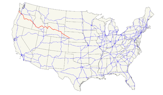
U.S. Route 97 is a major north–south United States highway in the western United States built in 1926. It begins at a junction with Interstate 5 at Weed, California, and travels north, ending in Oroville in Okanogan County, Washington, at the Canada–US border, across from Osoyoos, British Columbia, becoming British Columbia Highway 97 upon entering Canada. Major cities that lie on US 97 include Klamath Falls, Bend, and Redmond in Oregon and Yakima, Ellensburg, and Wenatchee in Washington.

U.S. Route 99 (US 99) was a main north–south United States Numbered Highway on the West Coast of the United States until 1964, running from Calexico, California, on the US–Mexico border to Blaine, Washington, on the U.S.-Canada border. It was assigned in 1926 and existed until it was replaced for the most part by Interstate 5. Known also as the "Golden State Highway" and "The Main Street of California", US 99 was important throughout much of the 1930s as a route for Dust Bowl immigrant farm workers to traverse the state. Large portions are now California's State Route 99 (SR 99), Oregon Route 99, 99W, 99E and Washington's SR 99. The highway connected to British Columbia Highway 99 at the Canada–US border.

The Siskiyou Trail stretched from California's Central Valley to Oregon's Willamette Valley; modern-day Interstate 5 follows this pioneer path. Originally based on existing Native American foot trails winding their way through river valleys, the Siskiyou Trail provided the shortest practical travel path between early settlements in California and Oregon.

Oregon Route 214 is an Oregon state highway which runs from the city of Woodburn, southeast into Silver Falls State Park in the Cascade foothills, and then loops back west towards Salem. The northern segment of the highway is known as the Hillsboro-Silverton Highway No. 140, a designation which continues north on OR 219, and the southern segment is known as the Silver Creek Falls Highway No. 163.
U.S. Route 97 in the U.S. state of Oregon is a major north–south United States highway which runs from the California border, south of Klamath Falls, to the Washington border on the Columbia River, between Biggs Junction, Oregon and Maryhill, Washington. Other than the northernmost stretch, US 97 is known as The Dalles-California Highway. In May 2009, Oregon Senate passed a bill to rename US 97 as "World War II Veterans Historic Highway".

Oregon Route 140 is a state highway in southern Oregon, United States. It is the longest state highway in Oregon, running 237 miles (381 km) from the community of White City, Oregon, through Klamath Falls and on to Lakeview. It then continues east, eventually descending into the state of Nevada.

Oregon Route 39 is an Oregon state highway that runs between the city of Klamath Falls in Southern Oregon, and the California border between Merrill, Oregon, and Tulelake, California.

Oregon Route 58, also known as the Willamette Highway No. 18, is a state highway in the U.S. state of Oregon. The route, signed east–west, runs in a southeast–northwest direction, connecting U.S. Route 97 north of Chemult with Interstate 5 south of Eugene. It links the Willamette Valley and Central Oregon, crossing the Cascade Range at Willamette Pass. OR 58 is generally a modern two-lane highway with a speed limit of 55 mph (88 km/h), built through the Willamette National Forest in the 1930s.

Oregon Route 62 is an Oregon state highway that runs between the city of Medford, and U.S. Route 97 between Chiloquin and Klamath Falls. The highway approaches Crater Lake National Park from the south, and is known as the Crater Lake Highway. While the highway is signed east-to-west, it is in reality shaped somewhat like a horseshoe; heading north-northeast from Medford, turning east as it approaches the park, and then turning south-southeast as it approaches Klamath Falls. Oregon Route 140 intersects with OR 62 in White City and Oregon Route 66. These are more direct routes between Medford and Klamath Falls. Route 62 comprises a portion of the Volcanic Legacy Scenic Byway.

Oregon Route 273 is an Oregon state highway running from OR 66 near Ashland to Interstate 5 near the California state line. OR 273 is known as the Siskiyou Highway No. 273. It is 12.42 miles (19.99 km) long and runs north-south parallel of I-5, entirely within Jackson County.
Interstate 5 (I-5) is a major north–south route of the Interstate Highway System in the United States, stretching from the Mexican border at the San Ysidro crossing to the Canadian border near Blaine, Washington. From San Ysidro, the segment of I-5 in California runs north across the length of the state, and crosses into Oregon south of the Medford-Ashland metropolitan area. It is the more important and most-used of the two major north–south routes on the Pacific Coast, the other being U.S. Route 101 (US 101), which is primarily coastal. I-5 is known colloquially as "the 5" to Southern California residents, "5" to Northern California residents.
Interstate 5 (I-5) in the U.S. state of Oregon is a major Interstate Highway that traverses the state from north to south. It travels to the west of the Cascade Mountains, connecting Portland to Salem, Eugene, Medford, and other major cities in the Willamette Valley and across the northern Siskiyou Mountains. The highway runs 308 miles (496 km) from the California state line near Ashland to the Washington state line in northern Portland, forming the central part of Interstate 5's route between Mexico and Canada.
Interstate 84 (I-84) in the U.S. state of Oregon is a major Interstate Highway that traverses the state from west to east. It is concurrent with U.S. Route 30 (US 30) for most of its length and runs 376 miles (605 km) from an interchange with I-5 in Portland to the Idaho state line near Ontario. The highway roughly follows the Columbia River and historic Oregon Trail in northeastern Oregon, and is designated as part of Columbia River Highway No. 2 and all of the Old Oregon Trail Highway No. 6; the entire length is also designated as the Vietnam Veterans Memorial Highway. I-84 intersects several of the state's main north–south roads, including US 97, US 197, I-82, and US 395.
U.S. Route 97 (US 97) is a United States Numbered Highway, stretching from Weed, California to the Canadian border in Oroville, Washington. The California portion of US 97 runs north from I-5 in Weed to the Oregon state line. This is the majority of a shortcut between I-5 and Klamath Falls, Oregon, added to both states' state highway systems in 1931.
State Route 15 is a west–east route from Memphis to Monteagle. For much of its route it has an unsigned concurrency with U.S. Route 64. SR 15 does travel through the southern part of all 3 Grand Divisions of the state: West Tennessee, Middle Tennessee, and East Tennessee.
Business routes of Interstate 5 exist in both California and Washington. There are no business routes in Oregon as that state does not assign for any of its highways. However, Oregon Route 99 essentially acts as a business route for most of Oregon, along with Oregon Route 99W and Oregon Route 99E

Pinehurst is an unincorporated community in Jackson County, Oregon, United States, on Oregon Route 66 about 25 miles (40 km) southeast of Ashland. It is along Jenny Creek near Round Prairie between the Siskiyou Mountains and the foothills of the Cascade Range.
There are 27 routes assigned to the "A" zone of the California Route Marker Program, which designates county routes in California. The "A" zone includes county highways in Lassen, Plumas, Shasta, Siskiyou, and Tehama counties.

