The Youngs River is a tributary of the Columbia River, approximately 27 miles (43 km) long, in northwest Oregon in the United States. It drains part of the Northern Oregon Coast Range in the extreme northwest corner of state, entering the Columbia via Youngs Bay just approximately 10 miles (16 km) from its mouth.

Mount Madison is a 5,367-foot (1,636 m) mountain in the Presidential Range of New Hampshire in the United States. It is named after the fourth U.S. President, James Madison.
Foundation Ice Stream is a major ice stream in the Pensacola Mountains of Antarctica. The ice stream drains northward for 150 nautical miles along the west side of the Patuxent Range and the Neptune Range to enter the Ronne Ice Shelf westward of Dufek Massif.

Mount Baker Wilderness is a 119,989-acre (48,558 ha) wilderness area within the Mount Baker-Snoqualmie National Forest in the western Cascade Range of northern Washington state. Its eastern border is shared with the boundary of the Stephen Mather Wilderness and North Cascades National Park for a distance of 40 miles. The wilderness extends from State Route 20 north to the Canada–US border. On the west, it is bounded by the foothills of the Puget Sound lowlands.
Zykov Glacier is a valley glacier about 25 nautical miles long in the Anare Mountains of Victoria Land, Antarctica. It flows northwest and reaches the coast between Cape Williams and Cooper Bluffs. It was photographed by the Soviet Antarctic Expedition (SovAE) in 1958 and named for student navigator Ye. Zykov, who died in Antarctica, Feb. 3, 1957.
Gayton Pickman Osgood was a member of the United States House of Representatives from state Massachusetts. He was born in Salem on July 4, 1797. He graduated from Harvard University in 1815, studied law, was admitted to the bar and commenced practice in Salem. He moved to North Andover. Osgood served as a member of the Massachusetts House of Representatives, and was elected as a Jacksonian to the Twenty-third Congress. He was an unsuccessful candidate for renomination in 1834. He retired from public life and engaged in agricultural pursuits. Osgood died in Andover on June 26, 1861. His interment was in the Old North Parish Burying Ground.
Simpson Glacier is a glacier, 6 nautical miles, in the Admiralty Mountains, Antarctica. It flows northward to the coast between Nelson Cliff and Mount Cherry-Garrard where it forms the Simpson Glacier Tongue.

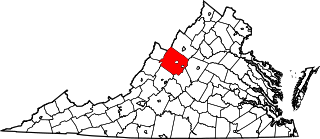
This is a list of the National Register of Historic Places listings in Augusta County, Virginia.

This is a list of the National Register of Historic Places listings in Madison County, Virginia.
Barnett Glacier is a large glacier in the Anare Mountains that flows east along the south side of Tapsell Foreland into Smith Inlet, northern Victoria Land, Antarctica.

The Boulder Mountains are part of the Rocky Mountains in the western United States. Located in central Idaho, they stretch from a few miles north of Ketchum to north to near Challis, and part of the range is within the Sawtooth National Recreation Area (SNRA) and partially within the Hemingway–Boulders Wilderness. The highest point in the range is Ryan Peak, at 11,714 feet (3,570 m) above sea level.

The Black Pine Mountains are a mountain range in the U.S. states of Idaho (~65%) and Utah (~35%), spanning Cassia County, Idaho and reaching into Box Elder County, Utah. The highest point in the range is known as Black Pine Mountains High Point, sometimes referred to as Black Peak, at 9,395 feet (2,864 m), and the range is a part of the Great Basin Divide and the Basin and Range Province. In Idaho, the mountains are part of the Black Pine Division of the Minidoka Ranger District of Sawtooth National Forest.

The Lemhi Range is a mountain range in the U.S. state of Idaho, spanning the eastern part of the state between the Lost River Range and the Beaverhead Mountains. The highest point in the range is Diamond Peak at 12,202 feet (3,719 m), the third highest peak in Idaho. The range is located within Salmon-Challis and Caribou-Targhee National Forests.


