
Osmanabad District officially known as Dharashiv District, is an administrative district in the Marathwada region in the Indian state of Maharashtra. The district headquarter is located at Osmanabad. The District of Osmanabad derives its name from the last ruler of Hyderabad, the 7th Nizam, Mir Osman Ali Khan, of which the region was a part till 1947. This region was earlier part of The Hyderabad State until Independence.This primarily rural district occupies an area of 7,569 km2 (2,922 sq mi) of which 241.4 km2 (93.2 sq mi) is urban and has a population of 1,657,576 of which 16.96% were urban.
Ingoda is a village with a Gram panchayat in the Paranda Tehsil of Osmanabad district, Maharashtra state in India.
Muktainagar is a town in Jalgaon district, Maharashtra, India. It is the administrative headquarter of its eponymous taluka. It is located in North Maharashtra region.
Bhoom is a town with a municipal council in Osmanabad district, Maharashtra, India, and it is the headquarters of Bhoom tahsil. Bhoom municipal corporation is established in 1948. Bhoom is a small town situated in a valley of the Banashankar hill ranges of Sahyadri. It is situated on the banks of the River Banaganga, which eventually flows into the Bhima. In 1717, Sambhaji II of Kolhapur gave Bhoom as jagir to Shrimant Senakhaskhel Yashwantrao Thorat (a chief and military leader of his troops) for his bravery. In 19th century Bhoom was under Nizam territory during the British raj in India. However it was independently ruled by the ' Thorat ' royal family. Shrimant Vijaysinh Amarsinh Thorat is the present head of Bhoom. He was the President of Bhoom Municipal Council from 1991 -2006.
Peth or Peint is the smallest tehsil of Nashik subdivision of Nashik district in Maharashtra, India. It belongs to Northern Maharashtra region. It belongs to Nashik Division. Peth is a Taluka headquarter. It is located 54 km to the West of Nashik District headquarters. It is also called as Peint. Pin code of Peth is 422208 and postal head office is Peth.
Walwa is a taluka in Sangli district in the Indian state of Maharashtra. It is also known as Walwa-Islampur Taluka. There are ninety-five panchayat villages in Walwa Taluka.
Washi is a Nagar panchayat village and the headquarters of Washi taluka in Bhoom subdivision of Osmanabad district of Maharashtra state in India. The village of Washi is 22 km by road northeast of the town of Bhoom, and 25 km by road northwest of Yermala. The nearest railway station is 40 km by road southwest to Yedshi in Osmanabad District.
Solapur South Taluka is one of the 11 tehsils of Solapur District in the Indian state of Maharashtra. This tehsil is located in the southeastern side of district and is bordered by Osmanabad District to the northeast, North Solapur and Mohol Taluka to the north, Akkalkot Taluka to the southeast, Karnataka's Kalaburagi district to the south, and Mangalvedhe Taluka to the west. The tehsil headquarters is located at Solapur, which is also the district headquarters and its largest city. Mandrup, Kumbhari, Valasang, Musti and Boramani are the biggest villages in south Solapur.
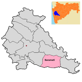
Baramati taluka is a taluka in Baramati subdivision of Pune district of state of Maharashtra in India.

Barshi Taluka is one of the 11 talukas of Solapur District in the Indian state of Maharashtra. This tehsil occupies the Northeast corner of the district and is bordered by Osmanabad District to the north and east, Madha Taluka to the west, Mohol Taluka to the southwest and North Solapur Taluka to the south. The tehsil headquarters is located at Barshi, which is also the largest city in the tehsil.
Terkheda is a panchayat village in Washi taluka of Osmanabad district in India. Terkheda is the only village listed in its gram panchayat, but it is surrounded by twelve small villages and has an old history; Hindus, Lingayats and Muslims all live together there. The village is surrounded by many hills and is next to the Tirna River. National Highway 211 runs just south of the main village.
Udgir Taluka, officially known as, Udayagiri Taluka, is a taluka and administrative subdivision of Latur District in the Indian state of Maharashtra. The administrative center for the taluka is the town of Udgir. In the 2011 census there were eighty-seven panchayat villages in Udgir Taluka.
Lohara Tehsil is a tehsil/taluka (subdistrict) in Osmanabad district, Maharashtra on the Deccan Plateau of India. Lohara Bk. is the administrative headquarters of the tehsil. There are forty-seven villages in Lohara Taluka.
Paranda Tahsil is a tahsil (subdistrict) in Osmanabad district, Marathwada region in Maharashtra on Deccan Plateau of India. The town of Paranda is the administrative headquarters of the tahsil. There are seventy-two panchayat villages in Paranda Tahsil.
Bhoom Tahsil is a tehsil in Osmanabad district, Maharashtra on the Deccan Plateau of India. The town of Bhoom is the administrative headquarters of the tahsil. There are seventy-four panchayat villages in Bhoom Tahsil. In 19th century Bhoom was under Nizam territory during the British raj in India. However it was independently ruled by the Thorat royal family. Shrimant Vijaysinh Amarsinh Thorat is the present head of Bhoom. He was the President of Bhoom Municipal Council from 1991 -2006.
Washi Tahsil is a tahsil/taluka (subdistrict) in Osmanabad district, Maharashtra on the Deccan Plateau of India. The town of Washi is the administrative headquarters of the tahsil. There are forty-three panchayat villages in Washi Tahsil.
Tuljapur Tahsil is a tahsil/taluka (subdistrict) in Osmanabad district, Maharashtra on the Deccan Plateau of India. The town of Tuljapur is the administrative headquarters of the tahsil. There are 107 panchayat villages in Tuljapur Tahsil.
Umarga (Omerga) Tehsil is a tehsil/ taluka/ subdistrict in Osmanabad district, Maharashtra on the Deccan Plateau of India. The town of Umarga is the administrative headquarters of the tehsil. There are 79 panchayat villages in Umarga Tehsil.
Alur is a panchayat village in the state of Maharashtra, India. It is administratively under the Umarga Tahsil of Osmanabad District in Maharashtra. There is only the single village of Alur in the Alur gram panchayat. The village is 31 km by road southeast of Naldurg and 52 km by road southwest of Umarga, but only 13 km by road northeast of Wagdari, in Solapur District.
Dadegaon is a village in Ashti tahsil of Beed District in Marathwada region of Maharashtra state, India.

