
Osmanabad District, officially known as Dharashiv District, is an administrative district in the Marathwada region in the Indian state of Maharashtra. The district headquarter is located at Osmanabad. The District of Osmanabad derives its name from the last ruler of Hyderabad, the 7th Nizam, Mir Osman Ali Khan, of which the region was a part till 1947. This region was earlier part of The Hyderabad State until Independence.This primarily rural district occupies an area of 7,569 km2 (2,922 sq mi) of which 241.4 km2 (93.2 sq mi) is urban and has a population of 1,657,576 of which 16.96% were urban.
Pandharpur is a popular pilgrimage town, on the banks of Chandrabhagā River, near Solapur city in Solapur District, Maharashtra, India. Its administrative area is one of eleven tehsils in the District, and it is an electoral constituency of the state legislative assembly. The Vithoba temple attracts about a million Hindu pilgrims during the major yātrā (pilgrimage) in Ashadha (June–July).
Murtijapur is a Municipal council and one of the taluka of district of Akola of the Amravati division of the Vidarbha region of Maharashtra.
Kudal is a census town in Sindhudurg district, Maharashtra, India. It is situated on River Karli in southwest Maharashtara. Kudal is the fourth largest town in Sindhudurg after Sawantwadi, Malvan and Kankavli. As of 2011, the population is 16,015. Kudal supports one MIDC area in the Konkan division. The Kudal railway station is located on the Konkan Railway route and connects the town with Mumbai metro situated in the Bombay, Baroda and Central India Railway of the north, and Mangalore on the south. It is a major stop for the Konkan Railway. The Deccan Odyssey train also stops in Kudal. National Highway 66 passes through Kudal. Apart from that, it also has two bus stations, a new one and old one. The old one is situated in market while the new one is just adjacent to the NH-66. Kudal is situated in centre of the Sindhudurg district and also considered one of the fastest-growing towns in the Konkan region. The Desai's were the original rulers of Kudal, who were tributaries of the Bijapur Sultanate, later the Marathas and then under the British.

Osmanabad, officially known as Dharashiv, is a city and a municipal council in Osmanabad district in the Indian state of Maharashtra. The city is the administrative headquarter of Osmanabad district. It is the seventh largest city in Marathwada, and the 39th largest city in Maharashtra by population.
Akkalkot is a city and a municipal council in Solapur district in the Indian state of Maharashtra. It is situated 38 km southeast of Solapur and close to the border of Karnataka state.

Latur district is a district in Maharashtra state of India. Latur city is the district headquarters and is the 16th largest city in the state of Maharashtra. The district is primarily agricultural. Urban population comprises 25.47% of the total population.
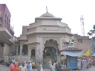
Tuljapur is a town with a municipal council in Osmanabad District in the Indian state of Maharashtra. It is the administrative seat of Tuljapur taluka.
Paranda is a town with a municipal council in the Osmanabad district of the Indian state of Maharashtra. It is the headquarters town for the Paranda Tehsil.
Vairag is a town in Barshi Taluka of Solapur district in Maharashtra, India. The village is located centrally between Solapur and Barshi.

Latur is a city and Tehsil place in Latur district in the Maharashtra state of India,Before 1982 city is a part of Osmanabad district. The city is a tourist hub surrounded by many historical monuments Kharosa Caves. The most spoken language in Latur is Marathi. The city's quality of education attracts students from all over Maharashtra. It is a drought prone area with acute water shortage in its city and rural areas. The economy is agriculture intensive, but in recent years is also dependent on Educational sector and its allied activities. Industrial development is minimal in the district. Latur is 43 kilometers from the epicenter of the devastating 1993 Latur earthquake.
Maan is not a city name. Dahiwadi taluka is called Maan taluka being it is situated on the Maan river. The subdivision Dahiwadi is in Satara district, Maharashtra, India. Dahiwadi is tehsil place of maan taluka.

Parner taluka is a taluka in Ahmednagar district in the state of Maharashtra in western India.
Umarga (Omerga) Tehsil is a tehsil/ taluka/ subdistrict in Osmanabad district, Maharashtra on the Deccan Plateau of India. The town of Umarga is the administrative headquarters of the tehsil. There are 79 panchayat villages in Umarga Tehsil.
Alur is a panchayat village in the state of Maharashtra, India. It is administratively under the Umarga Tahsil of Osmanabad District in Maharashtra. There is only the single village of Alur in the Alur gram panchayat. The village is 31 km by road southeast of Naldurg and 52 km by road southwest of Umarga, but only 13 km by road northeast of Wagdari, in Solapur District.
Madaj is a panchayat village in the state of Maharashtra, India. Administratively, Madaj is under Umarga Tehsil of Osmanabad District in Maharashtra. There is only the single village of Madaj in the Madaj gram panchayat. The village of Madaj is 17 km by road north of the town of Umarga and 20 km by road southeast of the village of Sastur.

Tourism in Marathwada refers to tourism in the Marathwada region of Maharashtra state in India. Aurangabad is a regional headquarters in Marathwada, and the tourism capital of Maharashtra state. Out of the four UNESCO World Heritage Sites in Maharashtra, two are in the Marathwada region. There are also 110 monuments in Marathwada which are protected by Government of Maharashtra and recognized by Archaeological Survey of India.
Yenegur is a major village located in Omerga tehsil of Osmanabad district, which is part of the Marathwada region of the state of Maharashtra in India.

