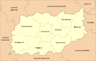
Kartuzy County is a unit of territorial administration and local government (powiat) in Pomeranian Voivodeship, northern Poland. It came into being on January 1, 1999, as a result of the Polish local government reforms passed in 1998. Its administrative seat and largest town is Kartuzy, which lies 29 kilometres (18 mi) west of the regional capital Gdańsk. The only other town in the county is Żukowo, lying 11 km (7 mi) east of Kartuzy.

Białystok County is a unit of territorial administration and local government (powiat) in Podlaskie Voivodeship, north-eastern Poland, on the border with Belarus. It was created on 1 January 1999 as a result of the Polish local government reforms passed in 1998. Its administrative seat is the city of Białystok, although the city is not part of the county. The county contains nine towns: Łapy, 25 km (16 mi) south-west of Białystok, Czarna Białostocka, 22 km (14 mi) north of Białystok, Wasilków, 11 km (7 mi) north of Białystok, Choroszcz, 13 km (8 mi) west of Białystok, Supraśl, 16 km (10 mi) north-east of Białystok, Michałowo, 13 km (8 mi) east of Białystok, Zabłudów, 16 km (10 mi) south-east of Białystok, Tykocin, 29 km (18 mi) west of Białystok, and Suraż, 23 km (14 mi) south-west of Białystok.

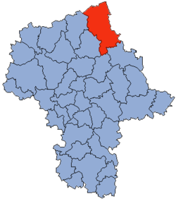
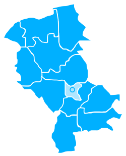
Wyszków County is a unit of territorial administration and local government (powiat) in Masovian Voivodeship, east-central Poland. It originally existed from 1956 until the abolition of the powiats in 1975, but was re-created on January 1, 1999, as a result of the Polish local government reforms passed in 1998, which reintroduced the powiats and created 16 large voivodeships. The administrative seat and only town in the county is Wyszków, which lies 53 kilometres (33 mi) north-east of Warsaw.

Łomża County is a unit of territorial administration and local government (powiat) in Podlaskie Voivodeship, north-eastern Poland. It came into being on January 1, 1999, as a result of the Polish local government reforms passed in 1998. Its administrative seat is the city of Łomża, although the city is not part of the county. The only towns in Łomża County are Nowogród, which lies 16 km (10 mi) north-west of Łomża, and Jedwabne, 20 km (12 mi) north-east of Łomża.

Warsaw West County is a unit of territorial administration and local government (powiat) in Masovian Voivodeship, east-central Poland. It came into being on January 1, 1999, as a result of the Polish local government reforms passed in 1998. In spite of its name, the county does not include any part of the city of Warsaw proper.

Maków County is a unit of territorial administration and local government (powiat) in Masovian Voivodeship, east-central Poland. It came into being on January 1, 1999, as a result of the Polish local government reforms passed in 1998. Its administrative seat and largest town is Maków Mazowiecki, which lies 73 kilometres (45 mi) north of Warsaw. The only other town in the county is Różan, lying 20 km (12 mi) east of Maków Mazowiecki.

Piaseczno County is a unit of territorial administration and local government (powiat) in Masovian Voivodeship, east-central Poland. It came into being on January 1, 1999, as a result of the Polish local government reforms passed in 1998. Its administrative seat and largest town is Piaseczno, which lies 17 kilometres (11 mi) south of Warsaw. The county contains three other towns: Konstancin-Jeziorna, 8 km (5 mi) east of Piaseczno, Góra Kalwaria, 18 km (11 mi) south-east of Piaseczno, and Tarczyn, 16 km (10 mi) south-west of Piaseczno.

Przasnysz County is a unit of territorial administration and local government (powiat) in Masovian Voivodeship, east-central Poland. It came into being on January 1, 1999, as a result of the Polish local government reforms passed in 1998. Its administrative seat and largest town is Przasnysz, which lies 90 kilometres (56 mi) north of Warsaw. The only other town in the county is Chorzele, lying 26 km (16 mi) north of Przasnysz.

Ostrów Mazowiecka County is a unit of territorial administration and local government (powiat) in Masovian Voivodeship, east-central Poland. It came into being on January 1, 1999, as a result of the Polish local government reforms passed in 1998. Its administrative seat and largest town is Ostrów Mazowiecka, which lies 89 kilometres (55 mi) north-east of Warsaw. The only other town in the county is Brok, lying 12 km (7 mi) south of Ostrów Mazowiecka.

Siedlce County is a unit of territorial administration and local government (powiat) in Masovian Voivodeship, east-central Poland. It came into being on January 1, 1999, as a result of the Polish local government reforms passed in 1998. Its administrative seat is the city of Siedlce, although the city is not part of the county. The only town in Siedlce County is Mordy, which lies 18 km (11 mi) east of Siedlce.

Płock County is a unit of territorial administration and local government (powiat) in Masovian Voivodeship, east-central Poland. It came into being on January 1, 1999, as a result of the Polish local government reforms passed in 1998. Its administrative seat is the city of Płock, although the city is not part of the county. The county contains three towns: Gąbin, 17 km (11 mi) south of Płock, Drobin, 29 km (18 mi) north-east of Płock, and Wyszogród, 39 km (24 mi) south-east of Płock.

Leszno County is a unit of territorial administration and local government (powiat) in Greater Poland Voivodeship, west-central Poland. It came into being on January 1, 1999, as a result of the Polish local government reforms passed in 1998. Its administrative seat is the city of Leszno, although the city is not part of the county. The only towns in Leszno County are Rydzyna, which lies 9 km (6 mi) south-east of Leszno, and Osieczna, 10 km (6 mi) north-east of Leszno.

Szczytno County is a unit of territorial administration and local government (powiat) in Warmian-Masurian Voivodeship, northern Poland. It came into being on January 1, 1999, as a result of the Polish local government reforms passed in 1998. Its administrative seat and largest town is Szczytno, which lies 45 kilometres (28 mi) south-east of the regional capital Olsztyn. The only other town in the county is Pasym, lying 18 km (11 mi) north-west of Szczytno.
Elbląg County is a unit of territorial administration and local government (powiat) in Warmian-Masurian Voivodeship, northern Poland. It came into being on January 1, 1999, as a result of the Polish local government reforms passed in 1998. Its administrative seat is the city of Elbląg, although the city is not part of the county. The county contains three towns: Pasłęk, 18 km (11 mi) east of Elbląg, Tolkmicko, 27 km (17 mi) north of Elbląg, and Młynary, 24 km (15 mi) north-east of Elbląg.
Goleniów County is a unit of territorial administration and local government (powiat) in West Pomeranian Voivodeship, north-western Poland. It came into being on January 1, 1999, as a result of the Polish local government reforms passed in 1998. Its administrative seat and largest town is Goleniów, which lies 22 kilometres (14 mi) north-east of the regional capital Szczecin. The county also contains the towns of Nowogard, lying 24 km (15 mi) north-east of Goleniów, and Maszewo, 19 km (12 mi) south-east of Goleniów.

Koszalin County is a unit of territorial administration and local government (powiat) in West Pomeranian Voivodeship, north-western Poland, on the Baltic coast. It came into being on January 1, 1999, as a result of the Polish local government reforms passed in 1998. Its administrative seat is the city of Koszalin, although the city is not part of the county. The county contains three towns: Sianów, 10 km (6 mi) north-east of Koszalin, Bobolice, 37 km (23 mi) south-east of Koszalin, and Polanów, 35 km (22 mi) east of Koszalin.

Opole County is a unit of territorial administration and local government (powiat) in Opole Voivodeship, south-western Poland. It came into being on January 1, 1999, as a result of the Polish local government reforms passed in 1998. Its administrative seat is the city of Opole, although the city is not part of the county. The county contains three towns: Ozimek, 20 km (12 mi) east of Opole, Niemodlin, 24 km (15 mi) west of Opole, and Prószków, 11 km (7 mi) south-west of Opole.

Gmina Myszyniec is an urban-rural gmina in Ostrołęka County, Masovian Voivodeship, in east-central Poland. Its seat is the town of Myszyniec, which lies approximately 38 kilometres (24 mi) north of Ostrołęka and 132 km (82 mi) north of Warsaw.