Otay Mountain | |
---|---|
Highest point | |
Elevation | 3,568 ft (1,088 m) NAVD 88 NAVD 88 [1] |
Prominence | 2,086 ft (636 m) [2] |
Coordinates | 32°35′40″N116°50′41″W / 32.594567222°N 116.844671506°W [1] |
Geography | |
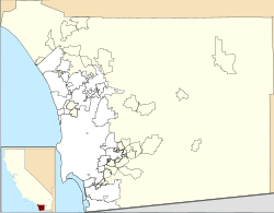
Location | San Diego County, California |
Parent range | San Ysidro Mountains |
Topo map | USGS Otay Mountain |
Climbing | |
Easiest route | Trail hike [3] |
Otay Mountain is a mountain located in San Diego County, California. It is the highest summit of the San Ysidro Mountains. The mountain is located in the Otay Mountain Wilderness Area. [3]
The Mexico-United States border runs along the south face of the mountain.
The name "Otay" comes from the Kumeyaay word otai, which means "brushy". [3]
On March 16, 1991, a Hawker Siddeley HS-125 airplane carrying seven members of singer Reba McEntire's band, plus her business manager and two pilots, crashed into the side of the mountain after taking off from nearby Brown Field Municipal Airport, killing all ten on board. [4] [5]
Otay Mountain has had several wildfire incidents in the past. The plant life in Otay Mountain "burned completely" in 2003, and another wildfire happened later in 2007. [6]
A border fence spanning the Mexico–United States border runs along the south face of Otay mountain in order to prevent illegal immigrants from crossing the national border. The border fence has received criticism for its effects on nature and wilderness. [7] In particular, the construction was criticized by author Rob Davis for creating a harsh environment for a species of butterfly due to dust being kicked up by trucks. [8] The fence in the area is estimated to cost approximately $16 million per mile. [9]
San Diego is a city on the Pacific Ocean coast in Southern California located immediately adjacent to the Mexico–United States border. With a population of over 1.3 million residents, the city is the eighth-most populous in the United States and the second-most populous in the state of California after Los Angeles. The city is the county seat of San Diego County, which had a population of nearly 3.3 million people as of 2021. San Diego is known for its mild year-round Mediterranean climate, extensive beaches and parks, its long association with the United States Navy, and its recent emergence as a healthcare and biotechnology development center.
Chula Vista is a city in San Diego County, California, United States. It is also the second-largest city in the San Diego metropolitan area, the seventh largest city in Southern California, the fifteenth largest city in the state of California, and the 82nd-largest city in the United States. The population was 275,487 as of the 2020 census, up from 243,916 as of the 2010 census. Located about halfway—7.5 miles (12.1 km)—between the two downtowns of San Diego and Tijuana in the South Bay, the city is at the center of one of the richest culturally diverse zones in the United States. Chula Vista is so named because of its scenic location between the San Diego Bay and coastal mountain foothills.
The Tijuana River is an intermittent river, 120 mi (195 km) long, near the Pacific coast of northern Baja California state in northwestern Mexico and Southern California in the western United States. The river is heavily polluted with raw sewage from the city of Tijuana, Mexico.
State Route 905 (SR 905), also known as the Otay Mesa Freeway, is an 8.964-mile-long (14.426 km) state highway in San Diego, in the southwestern part of the U.S. state of California. It connects I-5 and I-805 in San Ysidro to the Mexican border at Otay Mesa. The entire highway from I-5 to the international border is a freeway with a few exits that continues east from the I-805 interchange before turning southeast and reaching the border.
The Coconino National Forest is a 1.856-million acre United States National Forest located in northern Arizona in the vicinity of Flagstaff, with elevations ranging from 2,600 feet to the highest point in Arizona at 12,633 feet. Originally established in 1898 as the "San Francisco Mountains National Forest Reserve", the area was designated a U.S. National Forest by Pres. Theodore Roosevelt on July 2, 1908, when the San Francisco Mountains National Forest Reserve was merged with lands from other surrounding forest reserves to create the Coconino National Forest. Today, the Coconino National Forest contains diverse landscapes, including deserts, ponderosa pine forests, flatlands, mesas, alpine tundra, and ancient volcanic peaks. The forest surrounds the towns of Sedona and Flagstaff and borders four other national forests; the Kaibab National Forest to the west and northwest, the Prescott National Forest to the southwest, the Tonto National Forest to the south, and the Apache-Sitgreaves National Forest to the southeast. The forest contains all or parts of nine designated wilderness areas, including the Kachina Peaks Wilderness, which includes the summit of the San Francisco Peaks. The headquarters are in Flagstaff. The Coconino National Forest consists of three districts: Flagstaff Ranger District, Mogollon Rim Ranger District, and Red Rock Ranger District, which have local ranger district offices in Flagstaff, Happy Jack, and Sedona.
The South Bay, also known as South County, is a region in southwestern San Diego County, California consisting of the cities and unincorporated communities of Bonita, Chula Vista, East Otay Mesa, Imperial Beach, Lincoln Acres, National City, and South San Diego.
Otay Mesa is a community in the southern exclave of the city of San Diego, just north of the U.S.–Mexico border.
The Sweetwater River is a 55-mile (89 km) long stream in San Diego County, California.
The Tortilla Wall is a term given to a 14-mile section of United States border fence between the Otay Mesa Border Crossing in San Diego, California and the Pacific Ocean.
San Diego–Tijuana is an international transborder agglomeration, straddling the border of the adjacent North American coastal cities of San Diego, California, United States, and Tijuana, Baja California, Mexico. The 2020 population of the region was 5,456,577, making it the largest bi-national conurbation shared between the United States and Mexico, and the second-largest shared between the US and another country. The conurbation consists of the San Diego metropolitan area, in the United States and the municipalities of Tijuana, Rosarito Beach (126,980), and Tecate (108,440) in Mexico. It is the third most populous region in the California–Baja California region, smaller only than the metropolitan areas of Greater Los Angeles and the San Francisco Bay Area.
South San Diego is a district within the City of San Diego, and is in the larger South Bay region of southwestern San Diego County, California. South San Diego is a practical exclave of San Diego, having no land connection with the rest of the city. It is the only part of the city which borders Mexico. South San Diego includes four of the city's official community planning areas: Otay Mesa, Otay Mesa-Nestor, San Ysidro, and the Tijuana River Valley.
The Harris Fire was a major wildfire in southern San Diego County that began on October 21, 2007, which burned 90,440 acres (366.0 km2) in southeastern San Diego County before it was contained on November 5. Hotspots persisted until the fire was extinguished on November 16, making the Harris Fire the last of the October 2007 California wildfires to be extinguished. As the Harris Fire burned, it traveled in a northwest direction from its starting point at Harris Ranch Road in the town of Potrero, located in the far south of San Diego County, near Tecate, Mexico. The wildfire was the second-largest one of the October 2007 California wildfires, behind only the Witch Fire. The cause of the Harris Fire is unknown. The Harris Fire was the deadliest one of the October 2007 wildfires, killing eight people.
The San Ysidro Mountains are a mountain range in southern San Diego County, California and Baja California, Mexico. The mountains are a rugged coastal foothill range of the Peninsular Ranges system. Major peaks include the highest summit of the range, Otay Mountain, and the Cerro San Isidro which forms the southern extrusion of the range on the Mexican side of the border. The majority of the range is within the Otay Mountain Wilderness Area, in the United States.
San Diego County, officially the County of San Diego, is a county in the southwestern corner of the U.S. state of California. As of the 2020 census, the population was 3,298,634, making it California's second-most populous county and the fifth-most populous in the United States. Its county seat is San Diego, the second-most populous city in California and the eighth-most populous city in the United States. It is the southwesternmost county in the 48 contiguous United States, and is a border county. It is also home to 18 Native American tribal reservations, the most of any county in the United States.
East Otay Mesa is an as-yet undeveloped area in the South Bay region of unincorporated San Diego County, southern California.
Cross Border Xpress (CBX) is a border crossing and port of entry that connects San Diego in the United States and Tijuana International Airport in Mexico. Operational since December 2015, CBX consists of a terminal building located in the Otay Mesa community that is connected to the airport with a dedicated 120-meter (390 ft) pedestrian bridge that travels over the United States–Mexico border.
The Otay Mountain Wilderness is a U.S. Wilderness Area located in San Diego County, California, 12 miles east of the community of Otay Mesa and just north of the Mexican border. Some parts of the wilderness area rise quickly from sea level, reaching a peak of just over 3,500 feet (1,100 m) at the summit of Otay Mountain.
McGinty Mountain is a gabbroic mountain located in San Diego County, California near Jamul. Because of the gabbroic soil, the mountain supports numerous rare and endemic plant species, including half of California's population of the Dehesa nolina. The mountain belongs to an ecological preserve collectively managed by The Nature Conservancy, the California Department of Fish and Wildlife, and the San Diego National Wildlife Refuge. The mountain is accessible through a 4.7 mi (7.6 km) long out-and-back hiking trail.
The Smuggler's Gulch is part of a steep walled canyon about 2 miles (3.2 km) inland of the Pacific Ocean. The canyon crosses the Mexico–United States border, between Tijuana, Baja California, and San Diego, California, and Smuggler's Gulch is the part of the canyon on the US side of the border. It may also be called Cañón del Matadero or Valle Montezuma in Spanish, but these names apply more generally to the whole canyon. Smuggling activities within Smuggler's Gulch have occurred since the 19th century, giving this part of the canyon its name.
The Cerro Bola is a coastal metavolcanic mountain formation in northwestern Baja California. The Cerro Bola, along with the nearby mountain Cerro Gordo form the highest elevation areas of Tijuana Municipality. Because of its prominence, the transmitters for television station XHDTV and radio station XHPRS-FM are located on the summit of Cerro Bola, which reaches an elevation of 1,260 m (4,130 ft). It is located approximately 35 km (22 mi) south of the Tecate border crossing, and sits at the southwest end of the Valle de Las Palmas. The mountain range is host to a number of rare and endemic plant species, such as Arctostaphylos bolensis and Ceanothus bolensis.