Related Research Articles

Taupiri is a small town of about 450 people on the eastern bank of the Waikato River in the Waikato District of New Zealand. It is overlooked by Taupiri mountain, the sacred burial ground for the Waikato tribes of the Māori people, located just to the north.
Manunui is a small Whanganui River settlement, about 6 kilometres (3.7 mi) east of Taumarunui on State Highway 4, in New Zealand's King Country. It was once known as Waimarino, but John Burnand of the Ellis and Burnand sawmilling firm renamed it Manunui around 1905.
Nukuhau is a suburb of Taupo in the Waikato Region of New Zealand's North Island.
Kuratau is a small village north of Omori, on the western side of New Zealand's Lake Taupo. The population in the 2013 census was 273 people in 117 households; 22.0 percent of the population was under 15 and 15.4 percent were over 65. Approximately 76% of the population is of European origin and approximately 37% is of Maori origin. The most commonly spoken language is English.
Te Araroa is a town in the Gisborne Region of the North Island of New Zealand. It is situated 175 km north of Gisborne city, along State Highway 35 between Tokata and Awatere. Te Araroa is the birthplace of noted Māori politician Sir Āpirana Ngata. Māori in the area are generally associated with the Ngāti Porou iwi. It is 100 metres from its local beach.

Ranana is a settlement 60 kilometres (37 mi) up the Whanganui River from Whanganui, New Zealand.
Mokai is a rural community in the Taupo District and Waikato region of New Zealand's North Island.
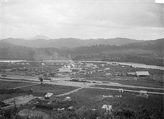
Rangiriri is a rural community in the Waikato District and Waikato region of New Zealand's North Island. It is located on the Waikato River near Lake Waikare in the Waikato District. State Highway 1 now bypasses Rangiriri.
Matangi is a settlement in the Waikato District on the eastern border of Hamilton. It is surrounded by many lifestyle blocks, but the village centre has Matangi School, a garage, Four Square, takeaway and café, Matangi Hall, St David’s church and Matangi recreation reserve.

Tauwhare is a small rural community in the Waikato District on the outskirts of Hamilton. The Waitakaruru Arboretum and Sculpture Park is located here.
Ohinewai or Ōhinewai is a small settlement in the Waikato Region, in New Zealand. It is located on the east bank of the Waikato River on SH1, 9 km north of Huntly
Putere is a village and rural community located in the Wairoa District of the Hawke's Bay Region, on New Zealand's North Island. It is located based around the small Lake Rotoroa and Lake Rotonuiaha.

Ongarue is a rural community in the Ruapehu District and Manawatū-Whanganui region of New Zealand's North Island. It is located south of Te Kuiti and Waimiha, and north of Taumarunui. It is in meshblock 1041902, which had a population of 54 in 2013.
Taringamotu is a valley and rural community in the Ruapehu District and Manawatū-Whanganui region of New Zealand's North Island.
Wharepapa South is a rural community in the Waipa District and Waikato region of New Zealand's North Island. It is located west of Putāruru and east of Te Awamutu.
Puketotara, or Puketōtara, is a rural community in the Otorohanga District and Waikato region of New Zealand's North Island.
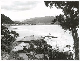
Hauturu is a village near the eastern shores of the Kawhia Harbour, in the Otorohanga District and Waikato region of New Zealand's North Island.
Rangitoto is a rural community in the Waitomo District and Waikato region of New Zealand's North Island.
Tuai is a village and rural community located around Lake Whakamarino, in the Wairoa District of the Hawke's Bay Region, on New Zealand's North Island.
Waotu or Te Waotu is a rural community in the South Waikato District and Waikato region of New Zealand's North Island.
References
- ↑ Hariss, Gavin. "Otewa, Waikato". topomap.co.nz. NZ Topo Map.
- ↑ "Te Kāhui Māngai directory". tkm.govt.nz. Te Puni Kōkiri.
- ↑ "Māori Maps". maorimaps.com. Te Potiki National Trust.
- ↑ "Ministry of Education School Profile". educationcounts.govt.nz. Ministry of Education.
- ↑ "New Zealand Schools Directory". New Zealand Ministry of Education. Retrieved 23 April 2022.
- ↑ "Education Review Office Report". ero.govt.nz. Education Review Office.
Coordinates: 38°13′52″S175°17′47″E / 38.231212°S 175.296297°E
| | This Waikato geography article is a stub. You can help Wikipedia by expanding it. |