LaPorte County is a county located in the U.S. state of Indiana. As of 2020, the population was 112,417. The county seat is the city of La Porte, and the largest city is Michigan City. This county is part of the Northwest Indiana and Michiana regions of the Chicago metropolitan area. The LaPorte County Courthouse is located in the county seat of La Porte and is listed on the National Register of Historic Places.

The Monon Railroad, also known as the Chicago, Indianapolis, and Louisville Railway from 1897 to 1971, was an American railroad that operated almost entirely within the state of Indiana. The Monon was merged into the Louisville and Nashville Railroad in 1971, and much of the former Monon right of way is owned today by CSX Transportation. In 1970, it operated 540 miles (870 km) of road on 792 miles (1,275 km) of track; that year it reported 1320 million ton-miles of revenue freight and zero passenger-miles.

Monon Township is one of twelve townships in White County, Indiana, United States. As of the 2020 census, its population was 3,286 and it contained 1,919 housing units.

Coolspring Township is one of twenty-one townships in LaPorte County, Indiana. As of the 2020 census, its population was 15,684 and it contained 7,302 housing units.
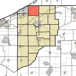
Springfield Township is one of twenty-one townships in LaPorte County, Indiana. As of the 2020 census, its population was 3,770 and it contained 1,574 housing units.
Creston is an unincorporated community that straddles the border between West Creek Township and Cedar Creek Township, Lake County, Indiana.
Byron is an unincorporated community in Kankakee Township, LaPorte County, Indiana.

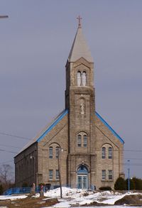
Door Village is an unincorporated community in Scipio Township, LaPorte County, Indiana. It was founded in 1836.

Hanna is an unincorporated community and census-designated place in Hanna Township, LaPorte County, Indiana, United States. It had a population of 463 at the 2010 census.
Holmesville is an unincorporated community in New Durham Township, LaPorte County, Indiana.

Hudson Lake is an unincorporated community and census-designated place (CDP) in Hudson Township, LaPorte County, Indiana, United States. The town sits on the dividing line between Central and Eastern time zones. It is the site of the Hudson Lake station stop of the South Shore Line. As of the 2010 census, the population of the CDP was 1,297.

Rolling Prairie is an unincorporated community and census-designated place (CDP) in Kankakee Township, LaPorte County, Indiana, United States. As of the 2020 census, it had a population of 562.
South Wanatah is an unincorporated community in Cass Township, LaPorte County, Indiana.

Union Mills is an unincorporated community in Noble Township, LaPorte County, Indiana.
Waterford is an unincorporated community in Coolspring Township, LaPorte County, Indiana, United States.
Wellsboro is an unincorporated community in Noble Township, LaPorte County, Indiana.

Lee is an unincorporated community in Monon Township, White County, in the U.S. state of Indiana.

Springville is an unincorporated community in Springfield Township in northern LaPorte County, Indiana, at the intersection of U.S. Route 20 and Indiana Route 39, less than one mile north of the LaPorte exit on the Indiana Toll Road. It took its name from a large spring that formerly flowed near the town.
Beattys Corner is an unincorporated community in LaPorte County, Indiana, in the United States.
Haskell is an unincorporated community in LaPorte County, Indiana, in the United States.