Rolling Prairie, Indiana

Last updated

Rolling Prairie, Indiana
LaPorte County Indiana Incorporated and Unincorporated areas Rolling Prairie Highlighted 1865736.svg
Location in LaPorte County, Indiana
USA Indiana location map.svg
Red pog.svg
Rolling Prairie
Usa edcp location map.svg
Red pog.svg
Rolling Prairie
Coordinates: 41°40′23″N86°37′26″W / 41.67306°N 86.62389°W / 41.67306; -86.62389
Country United States
State Indiana
County LaPorte
Township Kankakee
Area
[1]
  Total1.07 sq mi (2.77 km2)
  Land1.06 sq mi (2.74 km2)
  Water0.01 sq mi (0.04 km2)
Elevation
[2]
820 ft (250 m)
Population
 (2020)
  Total562
  Density532.20/sq mi (205.48/km2)
ZIP code
46371
FIPS code 18-65736 [3]
GNIS feature ID2629775 [2]

Rolling Prairie is an unincorporated community and census-designated place (CDP) in Kankakee Township, LaPorte County, Indiana, United States. As of the 2020 census, it had a population of 562.

Contents

History

The first cabin was built here in 1831 by Ezekiel Provolt. More settlers arrived, built cabins and named the settlement "Nauvoo". On November 26, 1853, the village was platted by J. W. Walker and named "Portland". [4] The name of "Rolling Prairie", descriptive of the undulating terrain, was later adopted by one of the railroad companies operating through the town. [5]

Rolling Prairie had a stop on the South Shore Line until 1994, [6] when it was closed along with several other flag stops with low ridership.

Geography

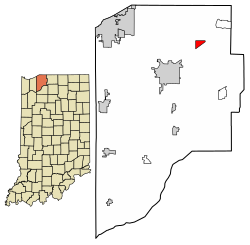
Rolling Prairie is located in northeastern LaPorte County in the northeast part of Kankakee Township. U.S. Route 20 passes through the southern side of the community, leading east 19 miles (31 km) to South Bend and west 15 miles (24 km) to Michigan City. Indiana State Road 2 passes just south of Rolling Prairie, leading southwest 7 miles (11 km) to La Porte, the county seat.

According to the U.S. Census Bureau, the Rolling Prairie CDP has an area of 1.1 square miles (2.8 km2), of which 0.02 square miles (0.04 km2), or 1.39%, are water. [7]

Education

Rolling Prairie has a public library, a branch of the La Porte County Public Library. [8] Rolling Prairie Elementary School occupies the building that was previously Rolling Prairie High School before the high school was merged with New Carlisle High School to form New Prairie High School. The elementary is one of three elementary schools in the New Prairie United School Corporation.

Demographics

Historical population
CensusPop.Note
2020 562
U.S. Decennial Census [9]

Related Research Articles

<span class="mw-page-title-main">Starke County, Indiana</span> County in Indiana, United States

Starke County is a county in the U.S. state of Indiana. As of the 2020 United States Census, its population was 23,371. The county seat is Knox.

<span class="mw-page-title-main">Porter County, Indiana</span> County in Indiana, United States

Porter County is a county in the U.S. state of Indiana. As of 2020, the population was 173,215, making it the 10th most populous county in Indiana. The county seat is Valparaiso. The county is part of Northwest Indiana, as well as the Chicago metropolitan area. Porter County is the site of much of the Indiana Dunes, an area of ecological significance. The Hour Glass Museum in Ogden Dunes documents the region's ecological significance.

<span class="mw-page-title-main">LaPorte County, Indiana</span> County in Indiana, United States

LaPorte County is a county located in the U.S. state of Indiana. As of 2020, the population was 112,417. The county seat is the city of La Porte, and the largest city is Michigan City. This county is part of the Northwest Indiana and Michiana regions of the Chicago metropolitan area. The LaPorte County Courthouse is located in the county seat of La Porte and is listed on the National Register of Historic Places.

<span class="mw-page-title-main">Wheatfield, Indiana</span> Town in Indiana, United States

Wheatfield is a town in Wheatfield Township, Jasper County, Indiana, United States. The population was 904 at the 2020 census.

<span class="mw-page-title-main">Michiana Shores, Indiana</span> Town in Indiana, United States

Michiana Shores is a town in Springfield and Michigan townships, LaPorte County, Indiana, United States. The population was 313 at the 2010 census. It is included in the Michigan City, Indiana-La Porte, Indiana Metropolitan Statistical Area. Michiana Shores is located in northwesternmost Springfield Township, and is the township's sole incorporated community.

<span class="mw-page-title-main">Michigan City, Indiana</span> City in Indiana, United States

Michigan City is a city in LaPorte County, Indiana, United States. It had a population of 31,479 at the 2010 census. Located along Lake Michigan in the Michiana region, the city is about 45 miles (72 km) east of Chicago and is 40 miles (64 km) west of South Bend.

<span class="mw-page-title-main">Hebron, Indiana</span> Town in Indiana, United States

Hebron is a town in Boone Township, Porter County, Indiana, United States. The population was 3,724 at the 2010 census.

<span class="mw-page-title-main">Granger, Indiana</span> Census-designated place in Indiana, United States

Granger is a census-designated place (CDP) in Clay and Harris townships, St. Joseph County, in the U.S. state of Indiana. The population was 30,465 at the 2010 census. Penn-Harris-Madison School Corporation and the South Bend Community School Corporation maintain the public schools in the area. Granger is part of the South Bend–Mishawaka metropolitan area as well as the larger Michiana region.

<span class="mw-page-title-main">New Carlisle, Indiana</span> Town in Indiana, United States

New Carlisle is a town in Olive Township, St. Joseph County, in the U.S. state of Indiana. The population was 1,891, as of the 2020 Census. It is part of the South Bend–Mishawaka, IN-MI, Metropolitan Statistical Area.

<span class="mw-page-title-main">Kankakee River</span> River in Indiana and Illinois, United States

The Kankakee River is a tributary of the Illinois River, approximately 133 miles (214 km) long, in the Central Corn Belt Plains of northwestern Indiana and northeastern Illinois in the United States. At one time, the river drained one of the largest wetlands in North America and furnished a significant portage between the Great Lakes and the Mississippi River. Significantly altered from its original channel, it flows through a primarily rural farming region of reclaimed cropland, south of Lake Michigan.

Waverly is a census-designated place (CDP) comprising the central community within Waverly Township in Lackawanna County, Pennsylvania, United States. Originally called Abington Center, it was founded in the late 18th century by settlers from Connecticut, along the Warriors' Path. The population of the CDP at the 2010 census was 604.

<span class="mw-page-title-main">Shelby, Indiana</span> Census-designated place in Indiana, United States

Shelby is an unincorporated community and census-designated place in Cedar Creek Township, Lake County, Indiana. Shelby had a population of 453 at the 2020 census.

<span class="mw-page-title-main">Kankakee Township, Jasper County, Indiana</span> Township in Indiana, United States

Kankakee Township is one of thirteen townships in Jasper County, Indiana, United States. As of the 2010 census, its population was 988 and it contained 410 housing units.

<span class="mw-page-title-main">Railroad Township, Starke County, Indiana</span> Township in Indiana, United States

Railroad Township is one of nine townships in Starke County, in the U.S. state of Indiana. As of the 2010 census, its population was 1,226 and it contained 549 housing units.

<span class="mw-page-title-main">Greene Township, St. Joseph County, Indiana</span> Township in Indiana, United States

Greene Township is one of thirteen townships in St. Joseph County, in the U.S. state of Indiana. As of the 2000 census, its population was 3,040.

Byron is an unincorporated community in Kankakee Township, LaPorte County, Indiana.

<span class="mw-page-title-main">Fish Lake, Indiana</span> Census-designated place in Indiana, United States

Fish Lake is an unincorporated community and census-designated place in Lincoln Township, LaPorte County, Indiana, United States. It is located where Indiana State Road 4 passes between Upper Fish Lake and Lower Fish Lake. These lakes feed the Kankakee River. As of the 2010 census, the population of the community was 1,016.

<span class="mw-page-title-main">Hanna, Indiana</span> Census-designated place in Indiana, United States

Hanna is an unincorporated community and census-designated place in Hanna Township, LaPorte County, Indiana, United States. It had a population of 463 at the 2010 census.

<span class="mw-page-title-main">Hudson Lake, Indiana</span> Census-designated place in Indiana, United States

Hudson Lake is an unincorporated community and census-designated place (CDP) in Hudson Township, LaPorte County, Indiana, United States. The town sits on the dividing line between Central and Eastern time zones. It is the site of the Hudson Lake station stop of the South Shore Line. As of the 2010 census, the population of the CDP was 1,297.

Saugany Lake is an unincorporated community and census-designated place (CDP) in LaPorte County, Indiana, United States.

References

  1. "2020 U.S. Gazetteer Files". United States Census Bureau. Retrieved March 16, 2022.
  2. 1 2 U.S. Geological Survey Geographic Names Information System: Rolling Prairie, Indiana
  3. "U.S. Census website". United States Census Bureau . Retrieved January 31, 2008.
  4. History of La Porte County, Indiana: Together with Sketches of Its Cities, Villages, and Townships. C. C. Chapman & Co. 1880. pp.  728.
  5. From Needmore to Prosperity - Baker, Ronald L. (1995) ISBN   0-253-32866-7
  6. Dodson, Paul (June 17, 1994). "South Shore Railroad Will Close 7 Flagstops". South Bend, IN: South Bend Tribune. p. B2.
  7. "U.S. Gazetteer Files: 2019: Places: Indiana". U.S. Census Bureau Geography Division. Retrieved January 23, 2020.
  8. "Homepage". La Grange County Public Library. Retrieved March 8, 2018.
  9. "Census of Population and Housing". Census.gov. Retrieved June 4, 2016.