
Interstate 35 (I-35) is a major Interstate Highway in the central United States. As with most primary Interstates that end in a five, it is a major cross-country, north–south route. It stretches from Laredo, Texas, near the Mexican border to Duluth, Minnesota, at Minnesota State Highway 61 and 26th Avenue East. The highway splits into I-35E and I-35W in two separate places, the Dallas–Fort Worth metroplex in Texas and at the Minnesota twin cities of Minneapolis–Saint Paul.

Ottawa County is a county located in the northeastern corner of the U.S. state of Oklahoma. As of the 2020 census, the population was 30,285. Its county seat is Miami. The county was named for the Ottawa Tribe of Oklahoma. It is also the location of the federally recognized Modoc Nation and the Quapaw Nation, which is based in Quapaw.

Ottawa is a city in, and the county seat of, Franklin County, Kansas, United States. It is located on both banks of the Marais des Cygnes River near the center of Franklin County. As of the 2020 census, the population of the city was 12,625. It is the home of Ottawa University.

Miami is a city in and county seat of Ottawa County, Oklahoma, United States, founded in 1891. Lead and zinc mining were established by 1918, causing the area's economy to boom.

Peoria is a town in Ottawa County, Oklahoma, United States. It was named for the Peoria people, a tribe of Native Americans who were removed to Indian Territory from east of the Mississippi River during the 19th century. The territory had been occupied by the Quapaw people, who sold some of their land to the Peoria. The population was 131 at the 2010 U. S. Census, down from 141 at the 2000 census. The long decline of mining meant that jobs moved elsewhere.

Wyandotte is a town in Ottawa County, Oklahoma, United States. The population was 333 at the 2010 census, a decline of 8.26 percent from the figure of 363 recorded in 2000. The town is the tribal headquarters of the Wyandotte Nation of Oklahoma, for which the town was named.

The Maumee River is a river running in the United States Midwest from northeastern Indiana into northwestern Ohio and Lake Erie. It is formed at the confluence of the St. Joseph and St. Marys rivers, where Fort Wayne, Indiana has developed, and meanders northeastwardly for 137 miles (220 km) through an agricultural region of glacial moraines before flowing into the Maumee Bay of Lake Erie. The city of Toledo is located at the mouth of the Maumee. The Maumee was designated an Ohio State Scenic River on July 18, 1974. The Maumee watershed is Ohio's breadbasket; it is two-thirds farmland, mostly corn and soybeans. It is the largest watershed of any of the rivers feeding the Great Lakes, and supplies five percent of Lake Erie's water.
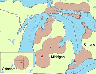
The Odawa, believed to derive from an Anishinaabe word meaning "traders", are an Indigenous American ethnic group who primarily inhabit land in the Eastern Woodlands region, commonly known as the northeastern United States and southeastern Canada. They have long had territory that crosses the current border between the two countries, and they are federally recognized as Native American tribes in the United States and have numerous recognized First Nations bands in Canada. They are one of the Anishinaabeg, related to but distinct from the Ojibwe and Potawatomi peoples.

The Peoria are a Native American people. They are enrolled in the federally recognized Peoria Tribe of Indians of Oklahoma headquartered in Miami, Oklahoma.

The Treaty of St. Mary's may refer to one of six treaties concluded in fall of 1818 between the United States and Natives of central Indiana regarding purchase of Native land. The treaties were

Green Country, sometimes referred to as Northeast Oklahoma, is the northeastern portion of the U.S. state of Oklahoma, which lies west of the northern half of Arkansas, the southwestern corner the way of Missouri, and south of Kansas.

The Neosho River is a tributary of the Arkansas River in eastern Kansas and northeastern Oklahoma in the United States. Its tributaries also drain portions of Missouri and Arkansas. The river is about 463 miles (745 km) long. Via the Arkansas, it is part of the Mississippi River watershed. Its name is an Osage word meaning "clear water." The lower section is also known as the Grand River.

State Highway 137 (SH-137) is a 6.31-mile (10.15 km) highway in Ottawa County, Oklahoma. It is a two-lane highway beginning at State Highway 10 east of Miami and ends at U.S. Highway 60 in Twin Bridges State Park on the north side of the Grand Lake o' the Cherokees. It has no lettered spur routes.

The historic U.S. Route 66, sometimes known as the Will Rogers Highway after Oklahoma native Will Rogers, ran from west to northeast across the state of Oklahoma, along the path now taken by Interstate 40 (I-40) and State Highway 66 (SH-66). It passed through Oklahoma City, Tulsa, and many smaller communities. West of the Oklahoma City area, it has been largely replaced by I-40; the few independent portions that are still state-maintained are now I-40 Business. However, from Oklahoma City northeast to Kansas, the bypassing I-44 is mostly a toll road, and SH-66 remains as a free alternate.
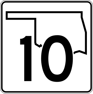
State Highway 10 is a state highway in northeastern Oklahoma. It makes a 233.1 miles (375.1 km) crescent through the northeast corner of the state, running from SH-99 in Osage County to Interstate 40 (I-40) near Gore. It has two lettered spur routes.

State Highway 125 is a state highway in northeastern Oklahoma that is 25.7 miles (41.4 km) long. It begins in the south at Grand Lake O' the Cherokees, ending in Miami at US-69/SH-10. It has no lettered spur routes.

State Highway 54 is a state highway in western Oklahoma. Running north–south, it exists in two parts, which lie at approximately the same longitude. The southern section's length is 9.96 miles (16.03 km), while the northern section runs for 85.5 miles (137.6 km), for a combined length of 95.5 miles (153.7 km). The northern section has two lettered spur routes.

U.S. Route 69 is a major north-south U.S. Highway in the U.S. state of Oklahoma. It extends the corridor formed by U.S. Route 75 in Texas, from Dallas northeast via McAlester and Muskogee to the Will Rogers Turnpike near Vinita. From Vinita to the Kansas state line, US-69 generally parallels the turnpike along old U.S. Highway 66.

U.S. Highway 59 (US-59) heads along the eastern portion of the state of Oklahoma. US-59's 216.47-mile (348.37 km) route through Oklahoma takes it through the mountainous terrain of the eastern Oklahoma Ouachitas and Ozarks. US-59 serves several lakes and towns through Oklahoma's Green Country, including Grand Lake, a major recreation center. The route enters the state from Arkansas near Fogel, Arkansas, and ends at the Kansas state line south of Chetopa, Kansas.

U.S. Route 60 (US-60) is a transcontinental U.S. highway extending from near Brenda, Arizona to Virginia Beach, Virginia on the Atlantic Ocean. Along the way, 352.39 miles (567.12 km) of the route lies within the state of Oklahoma. The highway crosses into the state from Texas west of Arnett and serves many towns and cities in the northern part of the state, including Arnett, Seiling, Fairview, Enid, Ponca City, Pawhuska, Bartlesville, and Vinita. US-60 exits Oklahoma near Seneca, Missouri. In Oklahoma, US-60 has three business routes, serving Tonkawa, Ponca City, and Seneca. The first 60.2 miles (96.9 km) of the route, from the Texas line to Seiling, is also designated as State Highway 51 (SH-51).


