Ottone, Emilia-Romagna

Last updated
Ottone
Comune
Comune di Ottone

Ottone-val Trebbia.JPG

Ottone
Ottone (PC)-Stemma.png
Coat of arms
Italy provincial location map 2015.svg
Red pog.svg
Ottone
Location of Ottone in Italy
Coordinates: 44°37′N9°20′E / 44.617°N 9.333°E / 44.617; 9.333
Country Italy
Region Emilia-Romagna
Province Piacenza (PC)
Frazioni Artana, Barchi, Belnome, Bertassi, Bertone, Bogli, Campi, Cattribiasca, Croce, Fabbrica, Frassi, Gramizzola, La Cà, Losso, Moglia, Monfagiano, Orezzoli là, Orezzoli qua, Ottone Soprano, Pizzonero, Rettagliata, Santa Maria, Semensi, Strassera, Suzzi, Tartago, Toveraia, Traschio, Truzzi, Valsigiara
Government
  Mayor Federico Beccia
Area
  Total 98.41 km2 (38.00 sq mi)
Elevation 510 m (1,670 ft)
Population (1 January 2016)
  Total 516
  Density 5.2/km2 (14/sq mi)
Demonym(s) Ottonesi
Time zone CET (UTC+1)
  Summer (DST) CEST (UTC+2)
Postal code29026
Dialing code 0523
Patron saint St. Bartholomew
Saint day August 24
Website Official website

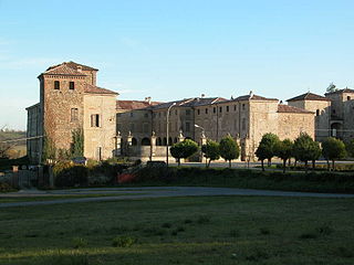
Ottone (Ligurian :Utùn; Piacentino: Uton) is a comune (municipality) in the Province of Piacenza in the Italian region Emilia-Romagna, located about 160 kilometres (99 mi) west of Bologna and about 60 kilometres (37 mi) southwest of Piacenza, in the upper Val Trebbia on the Ligurian Apennine. Ottone is the westernmost comune of Emilia-Romagna. The Mount Alfeo is located in its territory.

Ligurian (Romance language) Gallo-Romance language

Ligurian is a Gallo-Italic language spoken in Liguria in Northern Italy, parts of the Mediterranean coastal zone of France, Monaco and in the villages of Carloforte and Calasetta in Sardinia. It is part of the Gallo-Italic and Western Romance dialect continuum. The Genoese (Zeneize), spoken in Genoa, the capital of Liguria, is the language's prestige dialect on which the standard is based.

<i>Comune</i> third-level administrative divisions of the Italian Republic

The comune is a basic administrative division in Italy, roughly equivalent to a township or municipality.

Province of Piacenza Province of Italy

The province of Piacenza is a province in the Emilia-Romagna region of Italy. Its provincial capital is the city Piacenza. As of 2016, it has a total population of 286,572 inhabitants over an area of 2,585.86 square kilometres (998.41 sq mi), giving it a population density of 111.38 inhabitants per square kilometre. The city Piacenza has a population of 102,269, as of 2015. The provincial president is Patrizia Barbieri and it contains 48 comuni. The province dates back to its founding by the Romans in 218 BCE.

Pietro Toscanini, great-grandfather of Arturo Toscanini, was born in the Bogli borgo of Ottone, on 19 May 1769. [1]

Arturo Toscanini Italy-born American conductor

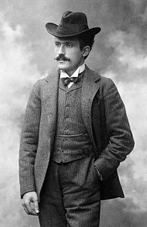
Arturo Toscanini was an Italian conductor. He was one of the most acclaimed musicians of the late 19th and of the 20th century, renowned for his intensity, his perfectionism, his ear for orchestral detail and sonority, and his eidetic memory. He was at various times the music director of La Scala in Milan, the Metropolitan Opera in New York, and the New York Philharmonic. Later in his career he was appointed the first music director of the NBC Symphony Orchestra (1937–54), and this led to his becoming a household name through his radio and television broadcasts and many recordings of the operatic and symphonic repertoire.

Related Research Articles

Agazzano Comune in Emilia-Romagna, Italy

Agazzano is a comune (municipality) in the Province of Piacenza in the Italian region Emilia-Romagna, located about 150 kilometres (93 mi) northwest of Bologna and about 20 kilometres (12 mi) southwest of Piacenza. As of 31 December 2004, it had a population of 2,021 and an area of 35.9 square kilometres (13.9 sq mi).

Alseno Comune in Emilia-Romagna, Italy

Alseno is a comune (municipality) in the Province of Piacenza in the Italian region Emilia-Romagna, located about 120 kilometres (75 mi) northwest of Bologna and about 25 kilometres (16 mi) southeast of Piacenza.

Cadeo Comune in Emilia-Romagna, Italy

Cadeo is a town and comune (municipality) in the Province of Piacenza in the Italian region Emilia-Romagna, located about 130 kilometres (81 mi) northwest of Bologna and about 14 kilometres (9 mi) southeast of Piacenza. It has about 5,600 inhabitants. The name is derived from Italian, meaning "House of God." This refers to a time when Cadeo was a stop-over for Christian pilgrims. The photo of the church accompanying this article is actually on the Via Emilia in Roveleto.

Calendasco Comune in Emilia-Romagna, Italy

Calendasco is a comune (municipality) in the Province of Piacenza in the Italian region Emilia-Romagna, located about 150 kilometres (93 mi) northwest of Bologna and about 9 kilometres (6 mi) northwest of Piacenza.

Caorso Comune in Emilia-Romagna, Italy

Caorso is a comune (municipality) in the Province of Piacenza in the Italian region Emilia-Romagna, located about 130 kilometres (81 mi) northwest of Bologna and about 13 kilometres (8 mi) east of Piacenza.

Carpaneto Piacentino Comune in Emilia-Romagna, Italy

Carpaneto Piacentino is a comune (municipality) in the Province of Piacenza in the Italian region of Emilia-Romagna, located about 130 kilometres (81 mi) northwest of Bologna and about 15 kilometres (9 mi) southeast of Piacenza.

Cerignale Comune in Emilia-Romagna, Italy

Cerignale is a comune (municipality) in the Province of Piacenza in the Italian region Emilia-Romagna, located about 160 kilometres (99 mi) west of Bologna and about 50 kilometres (31 mi) southwest of Piacenza. As of 31 December 2004, it had a population of 197 and an area of 31.5 square kilometres (12.2 sq mi).

Coli, Emilia-Romagna Comune in Emilia-Romagna, Italy

Coli is a comune (municipality) in the Province of Piacenza in the Italian region Emilia-Romagna, located about 160 kilometres (99 mi) west of Bologna and about 40 kilometres (25 mi) southwest of Piacenza. As of 31 December 2004, it had a population of 1,030 and an area of 72.2 square kilometres (27.9 sq mi).

Corte Brugnatella Comune in Emilia-Romagna, Italy

Corte Brugnatella is a comune (municipality) in the Province of Piacenza in the Italian region Emilia-Romagna, located about 160 kilometres (99 mi) west of Bologna and about 45 kilometres (28 mi) southwest of Piacenza.

Farini, Emilia-Romagna Comune in Emilia-Romagna, Italy

Farini is a comune (municipality) in the Province of Piacenza in the Italian region Emilia-Romagna, located about 140 kilometres (87 mi) west of Bologna and about 40 kilometres (25 mi) southwest of Piacenza. As of 31 December 2004, it had a population of 1,744 and an area of 112.0 square kilometres (43.2 sq mi).

Ferriere Comune in Emilia-Romagna, Italy

Ferriere is a comune (municipality) in the Province of Piacenza in the Italian region Emilia-Romagna, located about 150 kilometres (93 mi) west of Bologna and about 45 kilometres (28 mi) southwest of Piacenza, in the Val Nure of the Ligurian Appennines.

Gazzola Comune in Emilia-Romagna, Italy

Gazzola is a comune (municipality) in the Province of Piacenza in the Italian region Emilia-Romagna, located about 150 kilometres (93 mi) northwest of Bologna and about 15 kilometres (9 mi) southwest of Piacenza. As of 31 December 2004, it had a population of 1,856 and an area of 44.1 square kilometres (17.0 sq mi).

Lugagnano Val dArda Comune in Emilia-Romagna, Italy

Lugagnano Val d'Arda is a comune (municipality) in the Province of Piacenza in the Italian region Emilia-Romagna, located about 130 kilometres (81 mi) northwest of Bologna and about 30 kilometres (19 mi) southeast of Piacenza, on the Arda stream.

Pontenure Comune in Emilia-Romagna, Italy

Pontenure is a comune (municipality) in the Province of Piacenza in the Italian region Emilia-Romagna, located about 140 kilometres (87 mi) northwest of Bologna and about 9 kilometres (6 mi) southeast of Piacenza.

Rivergaro Comune in Emilia-Romagna, Italy

Rivergaro is a comune (municipality) in the Province of Piacenza in the Italian region Emilia-Romagna, located about 150 kilometres (93 mi) northwest of Bologna and about 20 kilometres (12 mi) southwest of Piacenza. As of 31 December 2011, it had a population of 6,843 and an area of 43.8 square kilometres (16.9 sq mi).

San Giorgio Piacentino Comune in Emilia-Romagna, Italy

San Giorgio Piacentino is a comune (municipality) in the Province of Piacenza in the Italian region Emilia-Romagna, located about 140 kilometres (87 mi) northwest of Bologna and about 11 kilometres (7 mi) south of Piacenza.

San Pietro in Cerro Comune in Emilia-Romagna, Italy

San Pietro in Cerro is a comune (municipality) in the Province of Piacenza in the Italian region Emilia-Romagna, located about 120 kilometres (75 mi) northwest of Bologna and about 20 kilometres (12 mi) east of Piacenza. As of 31 December 2004, it had a population of 962 and an area of 27.5 square kilometres (10.6 sq mi).

Travo Comune in Emilia-Romagna, Italy

Travo is a comune (municipality) in the Province of Piacenza in the Italian region Emilia-Romagna, located about 150 kilometres (93 mi) northwest of Bologna and about 25 kilometres (16 mi) southwest of Piacenza. It is on the left bank of the Trebbia river.

Vigolzone Comune in Emilia-Romagna, Italy

Vigolzone is a comune (municipality) in the Province of Piacenza in the Italian region Emilia-Romagna, located about 140 kilometres (87 mi) northwest of Bologna and about 15 kilometres (9 mi) south of Piacenza.

Zerba Comune in Emilia-Romagna, Italy

Zerba is a comune (municipality) in the Province of Piacenza in the Italian region Emilia-Romagna, located about 170 kilometres (110 mi) west of Bologna and about 50 kilometres (31 mi) southwest of Piacenza. As of 31 December 2004, it had a population of 123 and an area of 25.0 square kilometres (9.7 sq mi).

References