Gossolengo | ||
---|---|---|
Comune | ||
Comune di Gossolengo | ||
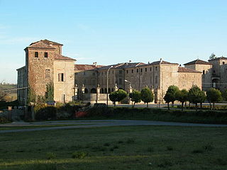
| ||
Coordinates: 45°0′N9°37′E / 45.000°N 9.617°E Coordinates: 45°0′N9°37′E / 45.000°N 9.617°E | ||
Country | Italy | |
Region | Emilia-Romagna | |
Province | Piacenza (PC) | |
Frazioni | Caratta, Quarto, Settima | |
Area | ||
• Total | 31.5 km2 (12.2 sq mi) | |
Population (Dec. 2004) [1] | ||
• Total | 4,197 | |
• Density | 130/km2 (350/sq mi) | |
Time zone | CET (UTC+1) | |
• Summer (DST) | CEST (UTC+2) | |
Postal code | 29020 | |
Dialing code | 0523 |
Gossolengo (Piacentino : Uslëing [usˈləi̯g] or Urslëing) is a comune (municipality) in the province of Piacenza in the Italian region Emilia-Romagna, located about 150 kilometres (93 mi) northwest of Bologna and about 9 kilometres (6 mi) southwest of Piacenza, in the valley of the Trebbia river.
The comune is a basic administrative division in Italy, roughly equivalent to a township or municipality.
The province of Piacenza is a province in the Emilia-Romagna region of Italy. Its provincial capital is the city Piacenza. As of 2016, it has a total population of 286,572 inhabitants over an area of 2,585.86 square kilometres (998.41 sq mi), giving it a population density of 111.38 inhabitants per square kilometre. The city Piacenza has a population of 102,269, as of 2015. The provincial president is Patrizia Barbieri and it contains 48 comuni. The province dates back to its founding by the Romans in 218 BCE.
Italy, officially the Italian Republic, is a country in Southern Europe. Located in the middle of the Mediterranean Sea, Italy shares open land borders with France, Switzerland, Austria, Slovenia and the enclaved microstates San Marino and Vatican City. Italy covers an area of 301,340 km2 (116,350 sq mi) and has a largely temperate seasonal and Mediterranean climate. With around 61 million inhabitants, it is the fourth-most populous EU member state and the most populous country in Southern Europe.
Gossolengo borders the following municipalities: Gazzola, Gragnano Trebbiense, Piacenza, Podenzano, Rivergaro.
Gazzola is a comune (municipality) in the Province of Piacenza in the Italian region Emilia-Romagna, located about 150 kilometres (93 mi) northwest of Bologna and about 15 kilometres (9 mi) southwest of Piacenza. As of 31 December 2004, it had a population of 1,856 and an area of 44.1 square kilometres (17.0 sq mi).
Gragnano Trebbiense is a comune (municipality) in the Province of Piacenza in the Italian region, Emilia-Romagna, located about 150 kilometres (93 mi) northwest of Bologna and about 11 kilometres (7 mi) southwest of Piacenza.
Piacenza is a city and comune in the Emilia-Romagna region of northern Italy, the capital of the eponymous province. The etymology is long-standing, tracing an origin from the Latin verb placēre, "to please." In French, and occasionally in English, it is called Plaisance. The name means a "pleasant abode", or as James Boswell reported some of the etymologists of his time to have translated it, "comely". This was a name "of good omen."
The area's economy is traditionally based on agriculture, thought the vicinity to Piacenza has boosted a considerable industrial and construction boom in recent times.
The Etruscan artifact dubbed "Liver of Piacenza" was found in the nearby in 1877.
The Liver of Piacenza is an Etruscan artifact found in a field on September 26, 1877, near Gossolengo, in the province of Piacenza, Italy, now kept in the Municipal Museum of Piacenza, in the Palazzo Farnese.
Podenzano is a comune in the Province of Piacenza, Emilia-Romagna, northern Italy.
Agazzano is a comune (municipality) in the Province of Piacenza in the Italian region Emilia-Romagna, located about 150 kilometres (93 mi) northwest of Bologna and about 20 kilometres (12 mi) southwest of Piacenza. As of 31 December 2004, it had a population of 2,021 and an area of 35.9 square kilometres (13.9 sq mi).
Alseno is a comune (municipality) in the Province of Piacenza in the Italian region Emilia-Romagna, located about 120 kilometres (75 mi) northwest of Bologna and about 25 kilometres (16 mi) southeast of Piacenza.
Cadeo is a town and comune (municipality) in the Province of Piacenza in the Italian region Emilia-Romagna, located about 130 kilometres (81 mi) northwest of Bologna and about 14 kilometres (9 mi) southeast of Piacenza. It has about 5,600 inhabitants. The name is derived from Italian, meaning "House of God." This refers to a time when Cadeo was a stop-over for Christian pilgrims. The photo of the church accompanying this article is actually on the Via Emilia in Roveleto.
Caorso is a comune (municipality) in the Province of Piacenza in the Italian region Emilia-Romagna, located about 130 kilometres (81 mi) northwest of Bologna and about 13 kilometres (8 mi) east of Piacenza.
Carpaneto Piacentino is a comune (municipality) in the Province of Piacenza in the Italian region of Emilia-Romagna, located about 130 kilometres (81 mi) northwest of Bologna and about 15 kilometres (9 mi) southeast of Piacenza.
Coli is a comune (municipality) in the Province of Piacenza in the Italian region Emilia-Romagna, located about 160 kilometres (99 mi) west of Bologna and about 40 kilometres (25 mi) southwest of Piacenza. As of 31 December 2004, it had a population of 1,030 and an area of 72.2 square kilometres (27.9 sq mi).
Corte Brugnatella is a comune (municipality) in the Province of Piacenza in the Italian region Emilia-Romagna, located about 160 kilometres (99 mi) west of Bologna and about 45 kilometres (28 mi) southwest of Piacenza.
Farini is a comune (municipality) in the Province of Piacenza in the Italian region Emilia-Romagna, located about 140 kilometres (87 mi) west of Bologna and about 40 kilometres (25 mi) southwest of Piacenza. As of 31 December 2004, it had a population of 1,744 and an area of 112.0 square kilometres (43.2 sq mi).
Ferriere is a comune (municipality) in the Province of Piacenza in the Italian region Emilia-Romagna, located about 150 kilometres (93 mi) west of Bologna and about 45 kilometres (28 mi) southwest of Piacenza, in the Val Nure of the Ligurian Appennines.
Lugagnano Val d'Arda is a comune (municipality) in the Province of Piacenza in the Italian region Emilia-Romagna, located about 130 kilometres (81 mi) northwest of Bologna and about 30 kilometres (19 mi) southeast of Piacenza, on the Arda stream.
Ponte dell'Olio is a comune (municipality) in the Province of Piacenza in the Italian region Emilia-Romagna, located about 22 kilometres (14 mi) south of Piacenza, about 85 kilometres (53 mi) south of Milan and about 160 kilometres (99 mi) northwest of Bologna. As of 31 December 2004, it had a population of 4,917 and an area of 44.0 square kilometres (17.0 sq mi).
Pontenure is a comune (municipality) in the Province of Piacenza in the Italian region Emilia-Romagna, located about 140 kilometres (87 mi) northwest of Bologna and about 9 kilometres (6 mi) southeast of Piacenza.
Rivergaro is a comune (municipality) in the Province of Piacenza in the Italian region Emilia-Romagna, located about 150 kilometres (93 mi) northwest of Bologna and about 20 kilometres (12 mi) southwest of Piacenza. As of 31 December 2011, it had a population of 6,843 and an area of 43.8 square kilometres (16.9 sq mi).
San Pietro in Cerro is a comune (municipality) in the Province of Piacenza in the Italian region Emilia-Romagna, located about 120 kilometres (75 mi) northwest of Bologna and about 20 kilometres (12 mi) east of Piacenza. As of 31 December 2004, it had a population of 962 and an area of 27.5 square kilometres (10.6 sq mi).
Travo is a comune (municipality) in the Province of Piacenza in the Italian region Emilia-Romagna, located about 150 kilometres (93 mi) northwest of Bologna and about 25 kilometres (16 mi) southwest of Piacenza. It is on the left bank of the Trebbia river.
Vigolzone is a comune (municipality) in the Province of Piacenza in the Italian region Emilia-Romagna, located about 140 kilometres (87 mi) northwest of Bologna and about 15 kilometres (9 mi) south of Piacenza.
Zerba is a comune (municipality) in the Province of Piacenza in the Italian region Emilia-Romagna, located about 170 kilometres (110 mi) west of Bologna and about 50 kilometres (31 mi) southwest of Piacenza. As of 31 December 2004, it had a population of 123 and an area of 25.0 square kilometres (9.7 sq mi).
Santo Stefano Lodigiano is a comune (municipality) in the Province of Lodi in the Italian region Lombardy, located about 60 kilometres (37 mi) southeast of Milan and about 25 kilometres (16 mi) southeast of Lodi.
This article on a location in Emilia–Romagna is a stub. You can help Wikipedia by expanding it. |