
Castel San Giovanni is a town and comune in the province of Piacenza, Emilia-Romagna, Italy.
Agazzano is a comune (municipality) in the Province of Piacenza in the Italian region Emilia-Romagna, located about 150 kilometres (93 mi) northwest of Bologna and about 20 kilometres (12 mi) southwest of Piacenza.

Borgonovo Val Tidone is a comune (municipality) in the Province of Piacenza in the Italian region Emilia-Romagna, located about 160 kilometres (99 mi) northwest of Bologna and about 20 kilometres (12 mi) west of Piacenza.
Carpaneto Piacentino is a comune (municipality) in the Province of Piacenza in the Italian region of Emilia-Romagna, located about 130 kilometres (81 mi) northwest of Bologna and about 15 kilometres (9 mi) southeast of Piacenza.

Castelvetro Piacentino, also known as Castelvetro, is a town and comune (municipality) in the Province of Piacenza in the Italian region Emilia-Romagna, located about 130 kilometres (81 mi) northwest of Bologna and about 25 kilometres (16 mi) east of Piacenza.
Ferriere is a comune (municipality) in the Province of Piacenza in the Italian region Emilia-Romagna, located about 150 kilometres (93 mi) west of Bologna and about 45 kilometres (28 mi) southwest of Piacenza, in the Val Nure of the Ligurian Apennines.
Gropparello is a comune (municipality) in the Province of Piacenza in the Italian region Emilia-Romagna, located about 130 kilometres (81 mi) northwest of Bologna and about 25 kilometres (16 mi) south of Piacenza.

Lugagnano Val d'Arda is a comune (municipality) in the Province of Piacenza in the Italian region Emilia-Romagna.
Morfasso is a comune (municipality) in the Province of Piacenza in the Italian region Emilia-Romagna, located about 130 kilometres (81 mi) west of Bologna and about 35 kilometres (22 mi) south of Piacenza. As of 31 December 2011, it had a population of 1,090 and an area of 83.6 square kilometres (32.3 sq mi).
Ottone is a comune (municipality) in the Province of Piacenza in the Italian region Emilia-Romagna, located about 160 kilometres (99 mi) west of Bologna and about 60 kilometres (37 mi) southwest of Piacenza, in the upper Val Trebbia on the Ligurian Apennine. Ottone is the westernmost comune of Emilia-Romagna. The Mount Alfeo is located in its territory.

Pianello Val Tidone is a comune (municipality) in the Province of Piacenza in the Italian region Emilia-Romagna, located about 160 kilometres (99 mi) northwest of Bologna and about 25 kilometres (16 mi) southwest of Piacenza.
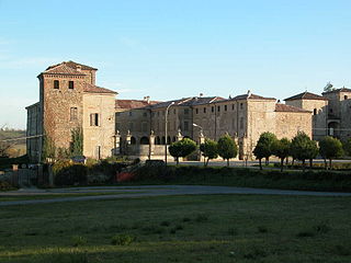
Piozzano is a comune (municipality) in the Province of Piacenza in the Italian region Emilia-Romagna, located about 150 kilometres (93 mi) northwest of Bologna and about 20 kilometres (12 mi) southwest of Piacenza.
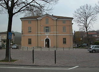
Ponte dell'Olio is a comune (municipality) in the province of Piacenza, in the Italian region of Emilia-Romagna, located about 22 kilometres (14 mi) south of Piacenza, about 85 kilometres (53 mi) south of Milan and about 160 kilometres (99 mi) northwest of Bologna. As of 31 December 2004, it had a population of 4,917 and an area of 44.0 square kilometres (17.0 sq mi).

Pontenure is a comune (municipality) in the Province of Piacenza in the Italian region Emilia-Romagna, located about 140 kilometres (87 mi) northwest of Bologna and about 9 kilometres (6 mi) southeast of Piacenza.
Rottofreno is a comune (municipality) in the Province of Piacenza in the Italian region Emilia-Romagna, located about 160 kilometres (99 mi) northwest of Bologna and about 12 kilometres (7 mi) west of Piacenza.
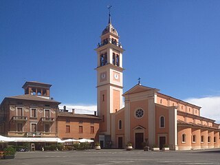
San Giorgio Piacentino is a comune (municipality) in the Province of Piacenza in the Italian region Emilia-Romagna, located about 140 kilometres (87 mi) northwest of Bologna and about 11 kilometres (7 mi) south of Piacenza.

Sarmato is a comune (municipality) in the Province of Piacenza in the Italian region Emilia-Romagna, located about 160 kilometres (99 mi) northwest of Bologna and about 15 kilometres (9 mi) west of Piacenza. As of 31 December 2004, it had a population of 2,714 and an area of 27.0 square kilometres (10.4 sq mi). Sarmato borders the following municipalities: Borgonovo Val Tidone, Castel San Giovanni, Monticelli Pavese, Pieve Porto Morone, Rottofreno.

Travo is a comune (municipality) in the Province of Piacenza in the Italian region Emilia-Romagna, located about 150 kilometres (93 mi) northwest of Bologna and about 25 kilometres (16 mi) southwest of Piacenza. It is on the left bank of the Trebbia river.

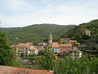
Vernasca is a comune (municipality) in the Province of Piacenza in the Italian region Emilia-Romagna, located about 120 kilometres (75 mi) northwest of Bologna and about 30 kilometres (19 mi) southeast of Piacenza. It is a member of the I Borghi più belli d'Italia association.

Alta Val Tidone is a new comune (municipality) in the Province of Piacenza in the Italian region Emilia-Romagna, located about 180 kilometres (110 mi) northwest of Bologna and about 30 kilometres (19 mi) southwest of Piacenza.


