Outwood, Wakefield

Last updated

Outwood
Church of St. Mary Magdalene, Outwood - geograph.org.uk - 1062059.jpg
Church of St. Mary Magdalene
West Yorkshire UK location map.svg
Red pog.svg
Outwood
Location within West Yorkshire
Population7,623 
OS grid reference SE330240
Metropolitan borough
Metropolitan county
Region
Country England
Sovereign state United Kingdom
Post town Wakefield
Postcode district WF1
Police West Yorkshire
Fire West Yorkshire
Ambulance Yorkshire
UK Parliament
List of places
UK
England
Yorkshire
53°42′43″N1°30′00″W / 53.712°N 1.500°W / 53.712; -1.500 Coordinates: 53°42′43″N1°30′00″W / 53.712°N 1.500°W / 53.712; -1.500

Outwood is a district to the north of Wakefield in West Yorkshire, England. The district is centred on the A61 Leeds Road south of Lofthouse. It grew up as a pit village and was only a small settlement until the 1970s, when construction of new houses caused it to grow and merge with neighbouring settlements such as Wrenthorpe and Stanley. In 2001, it had a population of 7,623. [1]

Contents

History

Not quite recorded in the Doomsday book, it is possible the settlement of Outwood gets its earliest literary mention in around 1400 in "The Lyttle Gest of Robyn Hode". Transcribed from at least a century of oral renditions telling the stories of Robin Hood and published in print form a century later in 1500, the prominent work features a mention of the name or phrase 'Outwoods'. This is quite possibly the earliest mention in any work of literature of one of England's greatest national myths alongside King Arthur and Joseph of Arimathea.

Outwood was the site of a pit disaster on 4 March 1879, when 21 people were killed in an explosion at Deep Drop Colliery. [2]

In 1905, the miners left homeless by the Kinsley evictions camped at Outwood Hall Farm, off Victoria Street, until they were able to return to their homes in Kinsley. [3]

The area near the railway station was once the site of Lofthouse pit, that is known for the disaster in March 1973 that claimed the lives of several miners. [4] The coal mine closed in 1981, and many of the coal miners subsequently took transfers to the new Selby Coalfield and left the village. [5] The site of the mine is now a golf course, now closed, and housing estate.

The Wakefield 41 Industrial Estate is also situated near to Outwood.

The parish church St Mary Magdalene was dedicated in 1858.

Transport

Outwood railway station is an unmanned station, served by Northern, offering rail services towards Leeds, Wakefield, Doncaster and Sheffield. The A61 (Leeds Road) runs through the middle of Outwood, connecting towards Leeds to the north and Wakefield to the south. Junction 41 of the M1 is also close-by.

Education

Outwood is home to Outwood Grange Academy, one of the largest secondary schools in the UK with over 2,100 students. The local primary schools are Outwood Primary Academy Ledger Lane (headteacher Rachael Skirrow) [6] and Rooks Nest Academy (headteacher Kimberley Dawson). [7]

Sport and recreation

Outwood is home to one park. Outwood Park has facilities for football, 5 a side, crown green bowling and a children's play area. Outwood is also home to two other playing fields and another play area. Local teams include Nightingale Football Club and Outwood Rangers Junior Football Club.

Local agriculture

Outwood is located within the Rhubarb Triangle. Because of its mining history Outwood has good supplies of soot and ash to condition its soil, which provide good conditions for the plant to grow.

Economy

CCE Wakefield is a main factory, with the rest of the Wakefield 41 industrial estate.

Elizabeth Anne Florist has served the area for many years.

See also

Related Research Articles

<span class="mw-page-title-main">Rothwell, West Yorkshire</span> Market Town in West Yorkshire, England

Rothwell is a town in the south-east of the City of Leeds metropolitan borough in West Yorkshire, England. It is situated between Leeds and Wakefield.

<span class="mw-page-title-main">Tingley</span> Village and suburb in West Yorkshire, England

Tingley is a suburban village in the City of Leeds in West Yorkshire, Northern England, forming part of the parish of West Ardsley. Tingley forms part of the Heavy Woollen District. It is situated between the cities of Leeds and Wakefield.

<span class="mw-page-title-main">Normanton, West Yorkshire</span> Town and civil parish in West Yorkshire, England

Normanton is a town and civil parish in the City of Wakefield in West Yorkshire, England. It is north-east of Wakefield and south-west of Castleford. The civil parish extends west and north to the River Calder, and includes the large village of Altofts. At the time of the 2011 Census, the population of the civil parish was 20,872.

<span class="mw-page-title-main">South Elmsall</span> Town and civil parish in West Yorkshire, England

South Elmsall is a town and civil parish in the City of Wakefield in West Yorkshire, England. South Elmsall lies to the east of Hemsworth The town had a population in 2001 of 6,107, increasing to 6,519 at the 2011 Census.

The Wakefield line is a railway line and service in the West Yorkshire Metro and South Yorkshire Passenger Transport Executive areas of northern England. The Wakefield line is coloured yellow on maps and publications by West Yorkshire Metro. The line was electrified in 1989, between Leeds & Wakefield Westgate, as part of the programme to electrify the East Coast Main Line.

<span class="mw-page-title-main">South Kirkby</span> Human settlement in England

South Kirkby is a town in the City of Wakefield in West Yorkshire, England which is governed locally by South Kirkby and Moorthorpe Town Council. The town forms half of the civil parish of South Kirkby and Moorthorpe. The parish has a population of 10,979.

<span class="mw-page-title-main">Normanton (UK Parliament constituency)</span> Parliamentary constituency in the United Kingdom, 1885-2010

Normanton was a county constituency represented in the House of Commons of the Parliament of the United Kingdom. It elected one Member of Parliament (MP) by the first past the post system of election.

<span class="mw-page-title-main">Wrenthorpe</span> Village in West Yorkshire, England

Wrenthorpe is a village north-west of Wakefield, in West Yorkshire, England. It is located in the Rhubarb Triangle.

Fitzwilliam is a small village on the edge of West Yorkshire, England, in the City of Wakefield district. The village falls within the Hemsworth ward of Wakefield City Council.

<span class="mw-page-title-main">Stanley, West Yorkshire</span> Village in West Yorkshire, England

Stanley is a village in the Metropolitan Borough of Wakefield in West Yorkshire, England. It is about 2.5 miles (4.0 km) north-east of Wakefield city centre. Stanley was an Urban District in the West Riding of Yorkshire before 1974, being made up the four electoral wards of Lake Lock, Outwood, Stanley and Wrenthorpe. The Lofthouse / Stanley area of West Yorkshire has a combined population of 22,947. The ward remaining at the 2011 Census was called Stanley and Outwood East. The population of this ward at the 2011 Census was 15,314.

<span class="mw-page-title-main">Lofthouse, West Yorkshire</span> Village in West Yorkshire, England

Lofthouse is a village between the cities of Wakefield and Leeds in West Yorkshire, England. The village falls within the Ardsley and Robin Hood ward of the City of Leeds Council. It is in the City of Leeds metropolitan borough but with a Wakefield postal address (WF3). It is mentioned as Locthuse, also as Loftose in the 1086 Domesday Book.

Robin Hood is a village in the City of Leeds in West Yorkshire, England. It is close to the City of Wakefield boundary and is situated between Leeds and Wakefield as well as being close to Rothwell and Lofthouse.

The South Yorkshire Coalfield is so named from its position within Yorkshire. It covers most of South Yorkshire, West Yorkshire and a small part of North Yorkshire. The exposed coalfield outcrops in the Pennine foothills and dips under Permian rocks in the east. Its most famous coal seam is the Barnsley Bed. Coal has been mined from shallow seams and outcrops since medieval times and possibly earlier.

<span class="mw-page-title-main">Lofthouse Colliery disaster</span>

The Lofthouse Colliery disaster was a mining accident in the West Riding of Yorkshire, England, on Wednesday 21 March 1973, in which seven mine workers died when workings flooded.

<span class="mw-page-title-main">Kinsley, West Yorkshire</span> Village in West Yorkshire, England

Kinsley is a village in the civil parish of Hemsworth, and the City of Wakefield district of West Yorkshire, England.

<span class="mw-page-title-main">Ardsley railway station</span> Disused railway station in West Yorkshire, England

Ardsley railway station was situated on the Great Northern Railway between Tingley and Lofthouse and Outwood on the main line and west of Stanley on the LNER & LMS Methley Joint Railway. It was built to serve the village of East Ardsley near Wakefield in the English county of West Yorkshire.

The Peckfield pit disaster was a mining accident at the Peckfield Colliery in Micklefield, West Yorkshire, England, which occurred on Thursday 30 April 1896, killing 63 men and boys out of 105 who were in the pit, plus 19 out of 23 pit ponies.

<span class="mw-page-title-main">Methley Joint Railway</span>

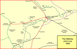
The Methley Joint Railway was a short English railway line constructed by the Bradford, Wakefield and Leeds Railway company, connecting its Leeds direction line with other companies' eastward routes to York, the north-east, and Goole. The line connected collieries along its route. The BW&LR changed its name to the West Yorkshire Railway at the same time. The line was double track, just over five miles in length, between junctions at Lofthouse and Methley.

<span class="mw-page-title-main">Bradford, Wakefield and Leeds Railway</span>

The Bradford, Wakefield and Leeds Railway was an independent railway company that built a line between Wakefield and a junction close to Leeds, in Yorkshire, England. It opened its main line in 1857, and was worked by the Great Northern Railway. The line shortened the GNR route to Leeds.

References

  1. "Census 2001 Neighbourhood Profile: Outwood" (PDF). Wakefield Council. Retrieved 20 March 2011.
  2. Stanley History Online - Deep Drop Colliery explosion
  3. "Outwood Hall Farm and evicted miners", Wakefield Express, page 30, 12 December 2014
  4. "Lofthouse Colliery Disaster".
  5. BBC Bradford & West Yorkshire - 'It was never the same again!'
  6. "Outwood Primary Academy Ledger Lane". EduBase. Department for Education . Retrieved 28 June 2020.
  7. "Rooks Nest Academy". EduBase. Department for Education . Retrieved 28 June 2020.