Pillsbury Baptist Bible College was an independent Baptist college in Owatonna, Minnesota, United States that operated from 1957 to 2008. Pillsbury described itself as a "biblical arts college." It offered a four-year program leading to the degrees of Bachelor of Arts in Bible and Bachelor of Science in Bible, as well as several associate degrees and a Bible certificate program.

The National Farmers' Bank of Owatonna, Minnesota, United States, is a historic bank building designed by Louis Sullivan, with decorative elements by George Elmslie.

The Merchants' National Bank (1914) building is a historic commercial building located in Grinnell, Iowa. It is one of a series of small banks designed by Louis Sullivan in the Midwest between 1909 and 1919. All of the banks are built of brick and for this structure he employed various shades of brick, ranging in color from blue-black to golden brown, giving it an overall reddish brown appearance. It was declared a National Historic Landmark in 1976 for its architecture. In 1991, it was listed as a contributing property in the Grinnell Historic Commercial District.

The Steele County Courthouse is the seat of government for Steele County, located in Owatonna, Minnesota, United States. It was built in 1891. The courthouse is a three-story Austin red-brick building with red mortar, accented with Lake Superior brown stone. It was designed by T. Dudley Allen of Minneapolis in a Romanesque Revival and Italianate style, featuring corner towers, a turret, and a large clock on four sides. Windows are arched and a statue representing Mercy, Law, and Justice sits above the north face of the building. Polished granite columns support double arches at the entrances. The interior is decorated with wainscoting, woodwork, and an ornate oak staircase. The courthouse was listed on the National Register of Historic Places in 1976 for having local significance in the themes of architecture and politics/government. It was nominated for its Romanesque Revival architecture and long service as Steele County's government seat.

Merchants National Bank is a bank building in Winona, Minnesota, United States, designed in the Prairie School architectural style. It was built in 1912 and features elaborate terracotta and stained-glass ornamentation. It was listed on the National Register of Historic Places in 1974 for having state-level significance in the themes of architecture and commerce. It was nominated for being the "largest and probably best example" of the 18 Midwestern banks designed by Purcell, Feick & Elmslie, a significant influence on early-20th-century American architecture. It is also a contributing property to the Winona Commercial Historic District.

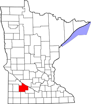
This is a list of the National Register of Historic Places listings in Rice County, Minnesota. It is intended to be a complete list of the properties and districts on the National Register of Historic Places in Rice County, Minnesota, United States. The locations of National Register properties and districts for which the latitude and longitude coordinates are included below, may be seen in an online map.

This is a list of the National Register of Historic Places listings in Stearns County, Minnesota. It is intended to be a complete list of the properties and districts on the National Register of Historic Places in Stearns County, Minnesota, United States. The locations of National Register properties and districts for which the latitude and longitude coordinates are included below, may be seen in an online map.
This is a list of the National Register of Historic Places listings in Redwood County, Minnesota. It is intended to be a complete list of the properties and districts on the National Register of Historic Places in Redwood County, Minnesota, United States. The locations of National Register properties and districts for which the latitude and longitude coordinates are included below, may be seen in an online map.

This is a list of the National Register of Historic Places listings in Itasca County, Minnesota. It is intended to be a complete list of the properties and districts on the National Register of Historic Places in Itasca County, Minnesota, United States. The locations of National Register properties and districts for which the latitude and longitude coordinates are included below, may be seen in an online map.

This is a list of the National Register of Historic Places listings in Le Sueur County, Minnesota. It is intended to be a complete list of the properties and districts on the National Register of Historic Places in Le Sueur County, Minnesota, United States. The locations of National Register properties and districts for which the latitude and longitude coordinates are included below, may be seen in an online map.

This is a list of the National Register of Historic Places listings in Wabasha County, Minnesota. It is intended to be a complete list of the properties and districts on the National Register of Historic Places in Wabasha County, Minnesota, United States. The locations of National Register properties and districts for which the latitude and longitude coordinates are included below, may be seen in an online map.
This is a list of the National Register of Historic Places listings in Houston County, Minnesota. It is intended to be a complete list of the properties and districts on the National Register of Historic Places in Houston County, Minnesota, United States. The locations of National Register properties and districts for which the latitude and longitude coordinates are included below, may be seen in an online map.

This is a list of the National Register of Historic Places listings in Kandiyohi County, Minnesota. It is intended to be a complete list of the properties and districts on the National Register of Historic Places in Kandiyohi County, Minnesota, United States. The locations of National Register properties and districts for which the latitude and longitude coordinates are included below, may be seen in an online map.

This is a list of the National Register of Historic Places listings in Steele County, Minnesota. It is intended to be a complete list of the properties and districts on the National Register of Historic Places in Steele County, Minnesota, United States. The locations of National Register properties and districts for which the latitude and longitude coordinates are included below, may be seen in an online map.

This is a list of the National Register of Historic Places listings in Chippewa County, Minnesota. It is intended to be a complete list of the properties and districts on the National Register of Historic Places in Chippewa County, Minnesota, United States. The locations of National Register properties and districts for which the latitude and longitude coordinates are included below, may be seen in an online map.

This is a list of the National Register of Historic Places listings in Lac qui Parle County, Minnesota. It is intended to be a complete list of the properties and districts on the National Register of Historic Places in Lac qui Parle County, Minnesota, United States. The locations of National Register properties and districts for which the latitude and longitude coordinates are included below, may be seen in an online map.

The Clinton Falls Bridge, also known as the Old Mill Bridge and formally as Bridge L-5573, is a historic steel Pratt through truss bridge that spans the Straight River in Clinton Falls Township, Minnesota. It was listed on the National Register of Historic Places in 1997 as Bridge No. L-5573 for having local significance in the theme of engineering. It was nominated for being an example of early steel truss bridge design in Minnesota.

Terrace is an unincorporated community in Chippewa Falls Township, Pope County, Minnesota, United States. The community was settled in the 1870s around the Terrace Mill. In 1982, a historic district of early buildings and structures was listed on the National Register of Historic Places as the Terrace Historic District for having local significance under the themes of exploration/settlement and industry. It was nominated as a well-preserved example of the small communities that grew up around Minnesota's rural mills in the latter 19th century.

The Owatonna Firemen's Hall, formerly the Owatonna City and Firemen's Hall, is a historic government building in Owatonna, Minnesota, United States. It was built from 1906 to 1907 to house the Owatonna Fire Department and city government offices. The city offices were relocated to the former campus of the Minnesota State Public School for Dependent and Neglected Children in 1974. The Firemen's Hall continues to serve as the headquarters for the Owatonna Fire Department.

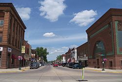
The Blooming Prairie Commercial Historic District is a designation applied to the historic downtown of Blooming Prairie, Minnesota, United States. It comprises 20 contributing properties built between 1893 and 1932. It was listed as a historic district on the National Register of Historic Places in 1994 for having local significance in the theme of commerce. It was nominated for being an unusually intact business district of an agricultural trade center on the Chicago, Milwaukee, and St. Paul Railroad.