
Withernsea is a seaside resort town and civil parish in Holderness, East Riding of Yorkshire, England. Its white inland lighthouse, rising around 127 feet (39 m) above Hull Road, now houses a museum to 1950s actress Kay Kendall, who was born in the town.

Aldborough is a village 7 miles (11 km) in the civil parish of Boroughbridge, to the north-east of Knaresborough, in North Yorkshire, England.

Garton on the Wolds is a village and a civil parish on the Yorkshire Wolds in the East Riding of Yorkshire, England. It is situated approximately 3 miles (5 km) north-west of Driffield town centre and lies on the A166 road.

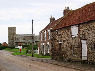
Aldbrough is a village and civil parish in the East Riding of Yorkshire, England, about 12 miles (19 km) north-east of Hull at the junction of the B1242 and B1238 roads. It lies near to the North Sea coast within the area of Holderness.

North Newbald is a village and former civil parish, now in the parish of Newbald, in the East Riding of Yorkshire, England. The village is situated approximately 13 miles (20 km) north-west of Hull city centre, 3 miles (5 km) north of South Cave and 3.5 miles (6 km) south of Market Weighton. It lies to the east of the A1034 road.

Long Riston is a village in the civil parish of Riston, in the East Riding of Yorkshire, England, in an area known as Holderness. It is situated approximately 9 miles (14 km) north of Kingston upon Hull city centre and 6 miles (10 km) east of Beverley town centre. It lies to the east of the A165 road which by-passes the village. In 1931 the parish had a population of 266. On 1 April 1935 the parish was abolished to form Riston.

Thwing is a village and civil parish in the Yorkshire Wolds, in the East Riding of Yorkshire, England.

South Dalton is a village and former civil parish, now in the parish of Dalton Holme, in the East Riding of Yorkshire, England. It is situated 6 miles (10 km) north-east of Market Weighton and 5 miles (8 km) north-west of Beverley. Etton lies 2 miles (3.2 km) to the south-east. North Dalton is 5 miles (8 km) north-west, with the villages of Middleton on the Wolds and Lund between. In 1931 the parish had a population of 233. On 1 April 1935 the parish was abolished and merged with Holme on the Wolds to form "Dalton Holme".

Waxholme is a hamlet in the civil parish of Rimswell, in the East Riding of Yorkshire, England. It is situated on the North Sea coast approximately 1 mile (1.6 km) north-west of Withernsea, off the B1242 road.
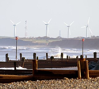
Tunstall is a village in the civil parish of Roos, in Holderness, in the East Riding of Yorkshire, England, close to the North Sea coast. It is situated approximately 3 miles (4.8 km) north-west of the town of Withernsea, and less than 0.6 miles (1 km) from the North Sea coast, at a height of 10 to 15 m above sea level, and close to the Prime Meridian at its northernmost point on land anywhere in the world.

Owstwick is a hamlet in the civil parish of Roos, in the East Riding of Yorkshire, England, in an area known as Holderness. It is approximately 11 miles (18 km) east of Kingston upon Hull city centre and 5 miles (8 km) north-west of Withernsea. It lies to the west of the B1242 road.
Out Newton is a hamlet in the civil parish of Easington, in the East Riding of Yorkshire, England, in an area known as Holderness. It is situated just inland from the North Sea coast, approximately 4.5 miles (7.2 km) south-east of Withernsea, and 4.5 miles (7.2 km) east of Patrington.

Kilnsea is a village in the civil parish of Easington, in the East Riding of Yorkshire, England, in an area known as Holderness. It is situated approximately 2 miles (3 km) south of the village of Easington, on the north bank of the Humber Estuary.

Kilnwick Percy is a village and former civil parish, now in the parish of Nunburnholme, in the East Riding of Yorkshire, England. It is situated approximately 1.5 miles (2.4 km) north-east of Pocklington town centre, and to the north of the B1246 road. In 1931 the parish had a population of 69. On 1 April 1935 the parish was abolished and merged with Nunburnholme.

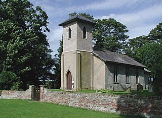
Hilston is a village in the civil parish of Roos, in the East Riding of Yorkshire, England, near the North Sea coast in an area known as Holderness. It is situated approximately 12 miles (19 km) east of Kingston upon Hull city centre and 5 miles (8 km) north-west of Withernsea. It lies to the east of the B1242 road. In 1931 the parish had a population of 27.
Goxhill is a small hamlet in the civil parish of Hatfield, in the East Riding of Yorkshire, England in an area known as Holderness. It is situated approximately 2 miles (3.2 km) south-west of Hornsea town centre. In 1931 the parish had a population of 70.

Fitling is a hamlet in the civil parish of East Garton, in the East Riding of Yorkshire, England, in an area known as Holderness. It is situated approximately 7 miles (11 km) north-west of Withernsea town centre. It lies 1 mile (1.6 km) west of the B1242 road.
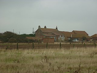
East Newton is a hamlet in the civil parish of Aldbrough, in the East Riding of Yorkshire, England, in an area known as Holderness. It is situated approximately 8 miles (13 km) north-west of Withernsea town centre. It lies to the east of the B1242 road on the North Sea coast.

Cowlam is a hamlet in the civil parish of Cottam, in the East Riding of Yorkshire, England, and in the Yorkshire Wolds. The hamlet is on the B1253 Bridlington to North Grimston road, 17 miles (30 km) north from the county town of Beverley, 2 miles (3 km) east from the village of Sledmere, and 2.5 miles (4 km) north-west from the parish hamlet of Cottam. The hamlet contains eight houses and two farms.

Old Malton is a village in the civil parish of Malton, in North Yorkshire, England. The village is situated just south of the A64 road and is 1-mile (1.5 km) north-east of the town of Malton. The village is on the B1257 which links Malton with the A64 and the A169 road to the north and is bounded on its eastern side by the River Derwent.

