Ozette, Washington

Last updated
Ozette, Washington
Unincorporated community
USA Washington location map.svg
Red pog.svg
Ozette
Location within the state of Washington
Coordinates: 48°09′17″N124°40′02″W / 48.15472°N 124.66722°W / 48.15472; -124.66722 Coordinates: 48°09′17″N124°40′02″W / 48.15472°N 124.66722°W / 48.15472; -124.66722
Country United States
State Washington
County Clallam
Time zone Pacific (PST) (UTC-8)
  Summer (DST) PDT (UTC-7)

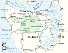
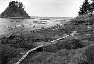
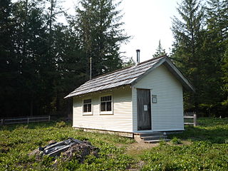
Ozette is an unincorporated community in Clallam County, Washington, United States. At 124 degrees, 40 minutes, 1 second West longitude, it is the westernmost populated area in the contiguous United States.[ citation needed ] The 22 mile long Hoko-Ozette Road, accessed via Washington State Route 112, terminates at the NPS Lake Ozette Ranger Station, within the coastal strip of Olympic National Park. The Lake Ozette Ranger Station, positioned at the north end of Ozette Lake, is approximately 3 miles from the Ozette Indian Village Archeological Site an important archaeological site of the Makah people, located in the now unpopulated Ozette Indian Reservation. The land between the Pacific coast and the Ozette River was settled by a small community of Scandinavian immigrants at the end of the 19th century; these being amongst the first Europeans to establish a permanent presence on the extreme western fringe of the Olympic Peninsula.

Unincorporated area Region of land not governed by own local government

In law, an unincorporated area is a region of land that is not governed by a local municipal corporation; similarly an unincorporated community is a settlement that is not governed by its own local municipal corporation, but rather is administered as part of larger administrative divisions, such as a township, parish, borough, county, city, canton, state, province or country. Occasionally, municipalities dissolve or disincorporate, which may happen if they become fiscally insolvent, and services become the responsibility of a higher administration. Widespread unincorporated communities and areas are a distinguishing feature of the United States and Canada. In most other countries of the world, there are either no unincorporated areas at all, or these are very rare; typically remote, outlying, sparsely populated or uninhabited areas.

Clallam County, Washington County in the United States

Clallam County is a county in the U.S. state of Washington. As of the 2010 census, the population was 71,404. The county seat and largest city is Port Angeles. The name is a Klallam word for "the strong people". The county was formed on April 26, 1854. Located on the Olympic Peninsula, it is south from the Strait of Juan de Fuca, which forms the Canada–US border, as British Columbia's Vancouver Island is across the strait.

Contiguous United States 48 states of the United States apart from Alaska and Hawaii

The contiguous United States or officially the conterminous United States consists of the 48 adjoining U.S. states on the continent of North America. The terms exclude the non-contiguous states of Alaska and Hawaii, and all other off-shore insular areas. These differ from the related term continental United States which includes Alaska but excludes Hawaii and insular territories.

The area is popular with back-packers and day-hikers, many of whom undertake to complete the 9.5 mile long Ozette Loop trail; commencing/terminating at Lake Ozette Ranger Station and taking in the coastal locations of Sand Point and Cape Alava .

Cape Alava cape

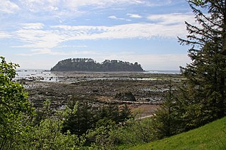
Cape Alava, in Clallam County, Washington, U.S., is the westernmost point in the contiguous 48 states. The westernmost point is located in Olympic National Park and the Makah Indian Reservation.

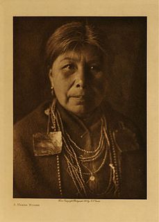
In 1997, a delegation from Mihama came to Ozette to commemorate the souls of three Japanese sailors whose ship ran aground in the area in 1834, and who were held briefly by the Makah before being released to Fort Vancouver. [1]

Mihama, Aichi Town in Japan

Mihama is a town located in Chita District, Aichi Prefecture, Japan. As of May 2015, the town had an estimated population of 24,306 and a population density of 526 persons per km². The total area was 46.39 square kilometres (17.91 sq mi).

Fort Vancouver fort

Fort Vancouver was a 19th-century fur trading post that was the headquarters of the Hudson's Bay Company's Columbia Department, located in the Pacific Northwest. Named for Captain George Vancouver, the fort was located on the northern bank of the Columbia River in present-day Vancouver, Washington. The fort was a major center of the regional fur trading. Every year trade goods and supplies from London arrived either via ships sailing to the Pacific Ocean or overland from Hudson Bay via the York Factory Express. Supplies and trade goods were exchanged with a plethora of Indigenous cultures for fur pelts. Furs from Fort Vancouver were often shipped to the Chinese port of Guangzhou where they were traded for Chinese manufactured goods for sale in the United Kingdom. At its pinnacle, Fort Vancouver watched over 34 outposts, 24 ports, six ships, and 600 employees. Today, a full-scale replica of the fort, with internal buildings, has been constructed and is open to the public as Fort Vancouver National Historic Site.

Ozette is the westernmost settlement in the state of Washington.[ citation needed ]

Related Research Articles

Neah Bay, Washington CDP in Washington, United States

Neah Bay is a census-designated place (CDP) on the Makah Reservation in Clallam County, Washington, United States. The population was 865 at the 2010 census. It is across the Canada–US border from British Columbia.

Olympic National Park national park of the United States

Olympic National Park is an American national park located in the State of Washington, on the Olympic Peninsula. The park has four regions: the Pacific coastline, alpine areas, the west side temperate rainforest and the forests of the drier east side. Within the park there are three distinct ecosystems which are subalpine forest and wildflower meadow, temperate forest, and the rugged Pacific coast.

Makah Native American people in Washington, US

The Makah are an indigenous American people living in Washington, in the Pacific Northwest of the continental United States. They are enrolled in the federally recognized Makah Indian Tribe of the Makah Indian Reservation.

Olympic Peninsula peninsula

The Olympic Peninsula is the large arm of land in western Washington that lies across Puget Sound from Seattle, and contains Olympic National Park. It is bounded on the west by the Pacific Ocean, the north by the Strait of Juan de Fuca, and the east by Hood Canal. Cape Alava, the westernmost point in the contiguous United States, and Cape Flattery, the northwesternmost point, are on the peninsula. Comprising about 3600 square miles, the Olympic Peninsula contained many of the last unexplored places in the Contiguous United States. It remained largely unmapped until Arthur Dodwell and Theodore Rixon mapped most of its topography and timber resources between 1898 and 1900.

Bly, Oregon Unincorporated community in Oregon, United States

Bly is an unincorporated small town in Klamath County, Oregon, United States. By highway, it is about 50 miles (80 km) east of Klamath Falls. As of 2000, the population was 486.

Hoh River river in the United States of America

The Hoh River is a river in the U.S. state of Washington, located on the Olympic Peninsula. About 56 miles (90 km) long, the Hoh River originates at the Hoh Glacier on Mount Olympus and flows west through the Olympic Mountains of Olympic National Park and Olympic National Forest, then through the foothills in a broad valley, emptying into the Pacific Ocean at the Hoh Indian Reservation. The final portion of the Hoh River's course marks the boundary between the coastal segment of Olympic National Park and Olympic National Forest, the Hoh Indian Reservation.

Kalaloch, Washington unincorporated community

Kalaloch is an unincorporated resort area entirely within Olympic National Park in western Jefferson County, Washington, United States. Kalaloch accommodations are on a 50-foot (15 m) bluff overlooking the Pacific Ocean, west of U.S. Highway 101 on the Olympic Peninsula, north of the reservation of the Quinault Indian Nation.

Tatoosh Island, Washington island in the United States of America

Tatoosh Island is a small island and small group of islands about 0.5 miles (0.8 km) offshore (northwest) of Cape Flattery, which is on the northwestern tip of the Olympic Peninsula in Washington. Tatoosh is the largest of a small group of islands also often referred to as simply "Tatoosh Island", which are almost as far west as Cape Alava, about 15 miles (24 km) to the south and the westernmost point in the contiguous 48 states. The islands are part of the Makah Reservation and a part of Clallam County. The total land area of the island group is 159,807 square metres.

La Push, Washington Unincorporated community in Washington, United States

La Push is a small unincorporated community situated at the mouth of the Quillayute River in Clallam County, Washington, United States. La Push is the largest community within the Quileute Indian Reservation, which is home to the federally recognized Quileute tribe. La Push is known for its whale-watching and natural environment.

Cape Flattery landform

Cape Flattery is the northwesternmost point of the contiguous United States. It is in Clallam County, Washington on the Olympic Peninsula, where the Strait of Juan de Fuca joins the Pacific Ocean. It is also part of the Makah Reservation, and is the northern boundary of the Olympic Coast National Marine Sanctuary. Cape Flattery can be reached from a short hike, most of which is boardwalked. The westernmost point in the contiguous United States is at Cape Alava, south of Cape Flattery in Olympic National Park. However, the westernmost tip of Cape Flattery is almost exactly as far west as Cape Alava, the difference being approximately 5 seconds of longitude, about 360 feet (110 m), at high tide and somewhat more at low tide.

Ozette Lake Lake in Clallam County, Washington, USA

Ozette Lake is the largest unaltered natural lake in Washington state at 29.5 km².

The Makah Museum also known as the Makah Cultural and Research Center is an archaeological and anthropological museum on the Makah Indian reservation in Neah Bay, Washington. It houses and interprets artifacts from the Ozette Indian Village Archeological Site, a Makah village partly buried by a mudslide at Lake Ozette around 1750, providing a snapshot of pre-contact tribal life. The museum includes a replica long house and thousands of artifacts of interest to academics and laypeople, including canoes, basketry, whaling and fishing gear.

Ozette Indian Village Archeological Site archaeological site in Washington state, USA

The Ozette Indian Village Archeological Site is the site of an archaeological excavation near Ozette on the Olympic Peninsula near Neah Bay, Washington, United States. The site was a village occupied by the Ozette Makah people until a mudslide inundated the site around the year 1750.

Makah Air Force Station

Makah Air Force Station is a closed United States Air Force General Surveillance Radar station. It is located 2.4 miles (3.9 km) south of Neah Bay, Washington. It was closed in 1988 by the Air Force, and turned over to the Federal Aviation Administration (FAA).

Peter Roose Homestead

The Peter Roose Homestead is a historic homestead that was settled by Peter Roose, an immigrant from Bollnäs, Sweden, in 1907. Located in Olympic National Park, the site was added as a historic district to the National Register of Historic Places in 2007.

Edward Eugene Claplanhoo was an American Makah elder and former chairman of the Makah Tribe, located on the northwest tip of the Olympic Peninsula in Washington state. Claplanhoo was the first Makah to earn a bachelor's degree. Claplanhoo was the chairman of the Makah during the excavation of the Ozette Indian Village Archeological Site in the 1970s. He is credited with keeping the artifacts uncovered at Ozette in Neah Bay. Under his leadership, the Makah Museum, which houses the Ozette collection, was established at Neah Bay in 1979. He also established Fort Núñez Gaona–Diah Veterans Park in Neah Bay in 2008.

Richard Deo Daugherty was an American archaeologist and professor, who led the excavation of the Ozette Indian Village Archeological Site in Washington state during the 1970s. The Ozette Indian Village, which was buried and preserved in a mudslide in the 1700s, has been called "most significant archaeological digs of the 20th century" in the Pacific Northwest. Daugherty collaborated closely with the Makah during the dig, which uncovered more than 55,000 artifacts.

Ozette potato potato

The Ozette, also known locally as Makah Ozette or Anna Cheeka's Ozette is the oldest variety of potato grown in the Pacific Northwest region. This potato, of the petite heirloom fingerling type, was grown for over two centuries by the Makah tribe native to Washington and was "rediscovered" in the late 1980s.

References