Padali

Last updated

Padali
Village
Heljai Mata Mandir.jpg
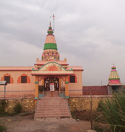
Heljai Mandir Padali
India Maharashtra location map.svg
Red pog.svg
Padali
Location in Maharashtra, India
Coordinates: 17°28′48″N74°11′09″E / 17.4801163°N 74.1856956°E / 17.4801163; 74.1856956 Coordinates: 17°28′48″N74°11′09″E / 17.4801163°N 74.1856956°E / 17.4801163; 74.1856956
CountryFlag of India.svg  India
State Maharashtra
District Satara
Government
  BodyGrampanchayat
   Sarpanch Surekha Jadhav
Elevation
56 m (184 ft)
Population
 (2011)
  Total3,550
Demonym(s) Padalkar
Time zone UTC+5:30 (IST)
PIN
415106
Telephone code+91-2164
Vehicle registration MH- 50
Website www.padali.in

Padali is a census village in the Satara district, in the Indian state of Maharashtra. It is surrounded by a Mountains on its three sides. There is a big temple of Heljaidevi Mandir at Village. Agriculture is the main occupation in the village with more than 75% of the total area being used for agricultural activities.

Contents

As per constitution of India and Panchyati Raaj Act, Padali village is administrated by Sarpanch (Head of Village) who is elected representative of village.

HeljaiMata Bachat Gat Tree Plantation 2016 Padaligaon.jpg
HeljaiMata Bachat Gat Tree Plantation 2016

History

As per constitution of India and Panchyati Raaj Act, Padali village is administrated by Sarpanch (Head of Village) who is elected representative of village.

List of Sarpanch

Geography

Padali is a village in Karad Taluka in Satara District of Maharashtra, India. It belongs to Desh or Paschim Maharashtra region and to Pune Division. It is located 32 km towards South from district headquarters Satara, 28  km from Karad, 276 km from state capital Mumbai. Pin code is 415106 and post office is Padali (Satara). Gaikwadwadi(1.5 km), Gosavewadi(1.5 km), Banugadewadi(1.3 km), Wather( 5.3 km ), Sathewadi( 2.5 km ), are the nearby villages to Padali. Padali is surrounded by Karad Taluka towards North Kadegaon Taluka, Kadegaon Taluka towards South, Koregaon Taluka towards east, Patan Taluka towards west.

Satara, Wai, Mahabaleswar, Karad are the nearby cities.

Locality

Railway station

Engineering Colleges Near Padali

Schools & Colleges near Padali

Related Research Articles

Alore Village in Maharashtra

Alore is a village in the Chiplun taluka of Ratnagiri district, Maharashtra, India. It lies on a bypass of the state highway linking the nearest town of Chiplun to Karad, and is located about 12.0 km (7.5 mi) east of the nearest town, that is Chiplun.

Pune division Place in Maharashtra, India

Pune division is one of the six administrative divisions of India's Maharashtra state. Pune Division is bound by Konkan Division to the west, Nashik Division to the north, Aurangabad Division to the east, and Karnataka State to the south.

Karad City in Maharashtra, India

Karad is a city in Satara district in the southern part of Indian state of Maharashtra and it is 320 km (180.19 miles) from Mumbai and 159 km from Pune. It lies at the confluence of Koyna River and the Krishna River known as the "Priti sangam". The two rivers originate at Mahabaleshwar, which is around 100 km from Karad. They diverge at their origin, and travel for about the same distance to meet again in Karad. The rivers meet exactly head on, thus forming letter "T" which is the only head on confluence in the world. Hence Krishna and Koyna river's confluence is called Preeti Sangam, meaning Confluence of Love. Karad is well known for sugar production and is known as the sugar bowl of Maharashtra owing to the presence of many sugar factories in and around Karad. It is considered as an important educational hub in Western Maharashtra due to the presence of many prestigious educational institutes. This place is also known for resting place or (Samadhi) of the first chief minister of Maharashtra Shri. Yashwantrao Chavan situated at the confluence of Krishna and Koyana river.

Ajri, India village in Karnataka, India

Ajri is a village in the southern state of Karnataka, India. It is part of Mysore Division.

Kadegaon is a city and taluka of Sangli district of Maharashtra in India.

Kudal (Satara) Village in Maharashtra

Kudal (कुडाळ) is a village in the Satara district, Maharashtra, India. It is surrounded by a river called Niranjana or Kudali. There is a big temple of 'Pimpleshwar & Wakadeshwar' at the river coast. Agriculture is the main land use in the village, with more than 75% of the total area being used for agricultural activities. The village has a close view to the historic Vairatgad Fort. It is central for 15 villages situated nearby Kudal Village.

Gundur is a village in Kalwakurthy taluk of Mahabubnagar district, Telangana, India.

Kotij Village in Maharashtra

Kotij is a suburb of Sangli District in the Indian state of Maharashtra.

Bori, Parbhani Village in Maharashtra

Bori is a village in Jintur taluka of Parbhani district in Maharashtra state of India.

Hajipurwadi is a village located in Vaijapur Taluka of Aurangabad district, Maharashtra with total 340 families residing. The Hajipurwadi village has population of 1560 of which 804 are males while 756 are females as per Population Census 2011. As per constitution of India and Panchyati Raaj Act, Hajipurwadi village is administrated by Sarpanch who is elected representative of village.

Devli Kalan Village in Rajasthan, India

Devli Kalan is a Village in Nawa Tehsil in Nagaur District of Rajasthan State, India. It belongs to Ajmer Division. It is located 176 km towards East from District headquarters Nagaur, 60 km from State capital Jaipur. Devli Kalan Pin code is 341507 and postal head office is Maroth. Renwal, Jaipur, Sambhar, Phulera, Reengus are the nearby Cities to Devli Kalan. Minda, Loonwa, Shyamgarh & KANCHANPURA 1.5 KM are the nearby Villages to Devli Kalan. As per constitution of India and Panchyati Raaj Act, Devli Kalan village is administrated by Sarpanch who is elected representative of village.

Dadegaon Village in Maharashtra

Dadegaon is a village in Ashti tahsil of Beed District in Marathwada region of Maharashtra state, India.

Ranisawargaon Village in Maharashtra

Ranisawargaon also Rani Sawargaon, is a major village in Gangakhed taluka of Parbhani district in Indian state of Maharashtra.

Karawadi Village in Maharashtra, India

Karawadi is a village panchayat located in the Karad taluka of Satara district in the southern part of Indian state of Maharashtra. It belongs to Western Maharashtra region. It has a population of 3,588 according to 2011 census. The nearby villages include Ogalewadi, Viravade, Wagheri. Prominent family surnames include Pisal, Patil, Chavan, Bhosale, More, Bansode, Dubal. It is in the Pune Division. It is located 57 km towards South from District headquarters Satara and 278 km from State capital Mumbai.

Ninam, Satara Village in Maharashtra

Ninam is a census village in Satara district, in the Indian state of Maharashtra. It is a village surrounded by greenery and farms but also mountains. Agriculture is the main land use in the village with more than 75% of the total area being used for agricultural activities. The village close to historic Ajinkyatara fort, which is to the north. The large Jyotirlinga temple is in the center of the village.

Erandoli is a village in Miraj Taluka in Sangli District of Maharashtra State, India. It belongs to Desh or Paschim Maharashtra region. It is in Pune Division. It is located 9 km East from the district headquarters Sangli and 361 km from the state capital at Mumbai

Sahara is a village in Bichpuri Block in Agra District of Uttar Pradesh State, India. It belongs to Agra Division. It is located 13 km towards west from District headquarters Agra. 3 km from Bichpuri. 356 km from State capital Lucknow

Gundala is a historical village since the princely state of Gondal.

Garavadi, Satara Village in Maharashtra

Garavadi (Ramnagar) is a census village in the Satara district, which is located in the India state of Maharashtra. There are a total of approximately 240 families residing within its borders. The village is located in the Khatav Tehsil of Satara district in Maharashtra, India. It is 32 km away from the sub-district headquarters of Vaduj, and 54 km away from the district headquarters of Satara. Research from 2009 shows that Garavadi village is also classified as a gram panchayat. According to the India Census in 2011, the village was recorded to have a population of 997, 478 of which were males, and the other 519 females.

Golegaon (Palam) is a small village in Purna taluka of Parbhani district in the Marathwada region of Maharashtra, Indiawith total 163 families residing. The Golegaon Palam village has population of 835 of which 454 are males while 381 are females as per Population Census 2011.

References