
The Upper Goyt Valley is the southern section of the valley of the River Goyt in North West England.

Hathersage is a village and civil parish in the Peak District in Derbyshire, England. It lies slightly to the north of the River Derwent, approximately 10 miles (16.1 km) south-west of Sheffield.

The Moss is a brook in North East Derbyshire, England.

The Hope Valley is a rural area centred on the village of Hope, Derbyshire, in the Peak District in the northern Midlands of England.

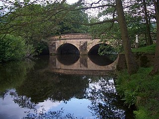
Grindleford is a village and civil parish in the county of Derbyshire, in the East Midlands of England. The population of the civil parish as taken at the 2011 Census was 909. It lies at an altitude of 492 feet (150 m) in the valley of the River Derwent in the Peak District National Park. The 17th-century Grindleford Bridge crosses the river on the western side of the village.

Hathersage railway station serves the village of Hathersage in the Derbyshire Peak District, in England.

Grindleford railway station serves the village of Grindleford in the Derbyshire Peak District, in England, although the station is about a mile way, the nearest village being Nether Padley.

Carl Wark is a rocky promontory on Hathersage Moor in the Peak District National Park, just inside the boundary of Sheffield, England. The promontory is faced by vertical cliffs on all but one side, which is protected by a prehistoric embankment. The cliffs and embankment form an enclosure that has been interpreted as an Iron Age hill fort, though the date of construction and purpose of the fortifications remains unknown. The site is a scheduled monument.

Hathersage Road is a road in Sheffield South Yorkshire, England and Derbyshire. It leads south-west from the suburb of Whirlow over the border between Hathersage and Sheffield, before becoming Sheffield Road at the point called Surprise View. The road begins at a bridge on the Limb Brook, the former boundary between Yorkshire and Derbyshire. There the road changes name from Ecclesall Road South to Hathersage Road.

Longshaw Estate is an area of moorland, woodland and farmland located within the Peak District National Park, Derbyshire, England.

The A6187 is a secondary route in the Peak District, Derbyshire and South Yorkshire, England. It starts in Castleton, runs in an easterly direction past Fox House Inn where it joins the A625 road. It is 13.6 miles long.

Burbage Brook is an upper tributary stream of the River Derwent in the Peak District of England.

Padley Chapel is a building in Grindleford, England, on the site of the former Padley Hall. It is a Grade I listed building.

Burbage Edge is a gritstone escarpment overlooking the Burbage district of Buxton in Derbyshire, in the Peak District. The hill's summit is 500 metres (1,600 ft) above sea level.

Padley Hall was an Elizabethan great house overlooking the River Derwent near Grindleford, Derbyshire, England. The remains of the hall today are mostly just foundation walls. The site is a protected Scheduled Monument. Not to be confused with 17th-century Padley Hall near Ripley.

Totley Moor is an open moorland hill to the west of the Sheffield suburb of Totley, in the Derbyshire Peak District. The summit is 395 metres (1,296 ft) above sea level.
Highlow is a civil parish within the Derbyshire Dales district, in the county of Derbyshire, England. Largely rural, Highlow's population is reported with the population of neighbouring parishes for a total of 585 residents in 2011. It is 140 miles (230 km) north-west of London, 28 miles (45 km) north-west of the county city of Derby, and 7+1⁄2 miles (12.1 km) north of the nearest market town of Bakewell. Highlow is wholly within the Peak District national park, and shares a border with the parishes of Abney and Abney Grange, Eyam, Foolow, Grindleford, Hathersage as well as Offerton. There are nine listed buildings in Highlow.
Curbar Edge is a gritstone moorland escarpment above the village of Curbar, in Derbyshire, England and close to the villages of Baslow, Calver, and Froggatt. It is located within the Peak District National Park at an altitude of 958 ft (292 m). It is regarded as a significant location for rock climbing, both regionally and nationally, in terms of both the historical development of the sport and as the location of first ascents.

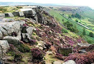
Burbage Rocks is a gritstone escarpment in South Yorkshire, overlooking the village of Hathersage in the Peak District. The highest point along the escarpment is 429 metres (1,407 ft) above sea level, whilst Burbage Moor rises above to 438 metres (1,437 ft). Burbage Rocks is a southern extension of Stanage Edge. Burbage Brook runs from the northern end of the Burbage Rocks, past the southern end, through Padley Gorge and into the RIver Derwent.

