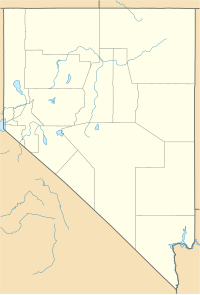
Clark County is located in the U.S. state of Nevada. As of the 2010 census, the population was 1,951,269, with an estimated population of 2,266,715 in 2019. Most of the county population resides in the Las Vegas Census County Divisions, which hold 1,771,945 people as of the 2010 Census, across 476 square miles (1,233 km2). It is by far the most populous county in Nevada, and the 11th most populous county in the United States. It covers 7% of the state's land area but holds 74% of the state's population, making Nevada one of the most centralized states in the United States.

Nye County is a county in the U.S. state of Nevada. As of the 2010 census, the population was 43,946. Its county seat is Tonopah. At 18,159 square miles (47,030 km2), Nye is Nevada's largest county by area and the third-largest county in the contiguous United States, behind Coconino County of Arizona and San Bernardino County of California.

The Las Vegas Valley is a major metropolitan area in the southern part of the U.S. state of Nevada, and the second largest in the Southwestern United States. The state's largest urban agglomeration, the Las Vegas Metropolitan Statistical Area is coextensive since 2003 with Clark County, Nevada. The Valley is largely defined by the Las Vegas Valley landform, a 600 sq mi (1,600 km2) basin area surrounded by mountains to the north, south, east and west of the metropolitan area. The Valley is home to the three largest incorporated cities in Nevada: Las Vegas, Henderson and North Las Vegas. Eleven unincorporated towns governed by the Clark County government are part of the Las Vegas Township and constitute the largest community in the state of Nevada.

The Funeral Mountains are a short, arid mountain range in the United States along the California-Nevada border approximately 100 mi (160 km) west of Las Vegas. The mountains are considered a subrange of the Amargosa Range that form the eastern wall of Death Valley.

The Spring Mountains are a mountain range of Southern Nevada in the United States, running generally northwest–southeast along the west side of Las Vegas and south to the border with California. Most land in the mountains is owned by the United States Forest Service and the Bureau of Land Management and managed as the Spring Mountains National Recreation Area within the Humboldt-Toiyabe National Forest and the Red Rock Canyon National Conservation Area.

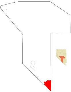
Amargosa Valley is an unincorporated town located on U.S. Route 95 in Nye County, in the U.S. state of Nevada.
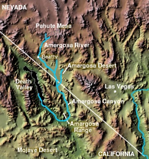
The Amargosa Valley is the valley through which the Amargosa River flows south, in Nye County, southwestern Nevada and Inyo County in the state of California. The south end is alternately called the "Amargosa River Valley'" or the "Tecopa Valley." Its northernmost point is around Beatty, Nevada and southernmost is Tecopa, California, where the Amargosa River enters into the Amargosa Canyon.

State Route 156, also known as Lee Canyon Road, is a state highway in Clark County, Nevada. The road is one of two highways connecting U.S. Route 95 to the Humboldt-Toiyabe National Forest and Spring Mountains area northwest of Las Vegas and its entire length is designated a Nevada Scenic Byway.
Carpenter Canyon is a canyon on the western side of the Spring Mountains, partially within the Humboldt-Toiyabe National Forest, in Clark County, southern Nevada west of the Las Vegas Valley.

Mountain Springs is an unincorporated community in Clark County in southern Nevada. It is located in Mountain Springs Summit, the pass over the Spring Mountains through which Highway 160 connects Las Vegas and Pahrump. Public buildings include a fire house and a saloon.

The Old Spanish Trail is a historical trade route that connected the northern New Mexico settlements of Santa Fe, New Mexico with those of Los Angeles, California and southern California. Approximately 700 mi (1,100 km) long, the trail ran through areas of high mountains, arid deserts, and deep canyons. It is considered one of the most arduous of all trade routes ever established in the United States. Explored, in part, by Spanish explorers as early as the late 16th century, the trail was extensively used by traders with pack trains from about 1830 until the mid-1850s.

The Amargosa Desert is located in Nye County in western Nevada, United States, along the California–Nevada border, comprising the northeastern portion of the geographic Amargosa Valley, north of the Ash Meadows National Wildlife Refuge
The Nopah Range is a mountain range located in Inyo County, California, United States, near the eastern border with Nevada.

State Route 160 is a state highway in southern Nevada, United States. It connects the southern Las Vegas Valley to U.S. Route 95 northwest of the city via the Pahrump Valley. The southern part of the route sees heavy traffic, mostly due to Pahrump's continued growth as a Las Vegas bedroom community.

The Black Mountains, a mid-Miocene formation, in Nevada are a series of rugged, arid rocky volcanic mountains ranging in elevations to 3310 ft. The range lies on the north shore of Lake Mead, at the southwest corner of the Overton Arm, about 25 mi south of Overton, Nevada.
Pahrump is an unincorporated town located at the southernmost tip of Nye County, Nevada, United States, about 62 miles (100 km) west of Las Vegas, Nevada. Pahrump lies adjacent to the Nevada–California border and the area had a 2018 population of 36,174.

Mountain Springs Summit [el. 5,502 ft (1,677 m)] is a mountain pass in the Spring Mountains of Southern Nevada in the United States.
Jean Pass (north) is one of two passes on the west and northwest of the Jean Dry Lake basin, an endorheic basin bordering Jean, Nevada.

Trout Canyon is an unincorporated community in Clark County, Nevada, United States.