Related Research Articles

Mansehra is a city in the Khyber Pakhtunkhwa province of Pakistan and the headquarters of Mansehra District. It is historically considered as the stronghold of the Swati tribe of Pashtuns.
Allai is a tehsil of Allai District in Pakistan's Khyber-Pakhtunkhwa province. It is home to the Allai Valley and district headquarters. Prince Muhammad Nawaz Khan Swati is the current "Chief of Allai Valley".

Battagram is a tribal district in Hazara Division of Khyber Pakhtunkhwa province in Pakistan. The headquarter is Battagram, which is about 75 km from Mansehra city. It was part of historic Yaghistan before 1955. Later in 1955, It was merged into Pakistan and made part of neighboring Mansehra District with the status of Tehsil. It was officially separated from Mansehra District on July 1993 and was given the status of district. Battagram District was ruled by many different Khans, all belonging to the Swati tribe.

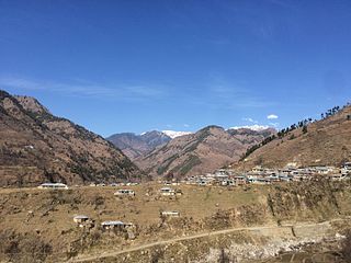
Thakot or Takot is a tribal town on the Indus River in Battagram District of Khyber Pakhtunkhwa, Pakistan. It is also one of twenty Union Councils of Battagram District, and one of twelve in Battagram Tehsil. Thakot is located midway between Battagram town in the south and Besham town in the north, at a distance of about 30 km from both.
Dhodial is an important town and union council located near Baffa between Mansehra and Shinkiari in Mansehra District in Khyber Pakhtunkhwa province of Pakistan. Dhodial is a fertile region known for its vegetables and tobacco crop. Dhodial is also well known for its pheasant conservation project. The town was badly affected by the 2005 Pakistan earthquake.
Belian is a village in Pakistan. It is located in Oghi Tehsil and lies to the north east of the district capital Mansehra it lies in area affected by the 2005 Kashmir earthquake, it lies 60 km east of the epicentre of the 2005 Kashmir earthquake.
Gijbori is a town, and one of twenty union councils of Battagram District in Khyber Pakhtunkhwa province of Pakistan. Also a part and a big village of Deshan Territory. It comprises many small villages. These include kandi is head village of this union council Torkhail clan is living here and this clan take important role in politics of this union council and also of all district.
Trand is a town in Battagram District in Khyber Pakhtunkhwa province of Pakistan, one of 20 union councils in the district. It is located at 34°37'60N 72°58'60E and has an altitude of 1,303 metres (4278 feet).
Battagram Tehsil is an administrative subdivision (Tehsil) of the Battagram District in the Khyber Pakhtunkhwa province of Pakistan. It serves as the Tehsil headquarters and covers a total area of 300 square miles (780 km2). Battagram Tehsil merged into Pakistan as an administrative region before being raised to the status of a district in 1993. On October 8, 2005, a 7.6 magnitude earthquake in Kashmir badly affected the area.
Kuza Bandai is a well developed village in Swat Valley of Khyber Pakhtunkhwa, Pakistan. It is known for its natural environment and also known as an area crossed by Alexander the Great. Later, after the Lal Masjid battle, Kuza Bandai and Bara Bandai became sympathetic to the Taliban movement. The village consists of Yusufzai Pakhtun tribes. It is one of Pakistan's Provincially Administered Tribal Areas (PATA).
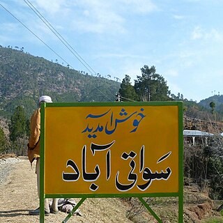
Swatiabad “سواتی آباد” is a village in Kathai union council, Tehsil Oghi, of Mansehra District in Khyber Pakhtunkhwa province of Pakistan. 9.2 km from main city of Oghi on Battal Road, It lies in an area affected by the 2005 Balkot earthquake. 34°31'42.35" N 73°06'04.19" E
Phagora is a village of union council Rajdhari in Battagram District, Khyber Pakhtunkhwa along the main silk route or SHAHRA-E-RESHAM. Phagora Village is one of the biggest village in Battagram and is located in mountainous area of Hazara Division. Phagora is 7 km from district headquarters Battagram and 200 km from the capital of Pakistan, Islamabad.
Dherai Bahader Khan is a small village in Kuza Banda, southern Battagram district, Khyber Pakhtunkhwa province, Pakistan. It is located at 34°38'9.51"N 73° 0'27.98"E, at an altitude of 1218 m, on the Oghi Battagram Road. The town was founded by Zaman Khan, father of Haji Bahader Khan, about 150 years ago. Residents belong to the Torkhel sub-tribe of the Deshan tribe of Swati.
Chaudhary Aslam Khan Swati was a Pakistani police officer. From 2005 to 2014 Aslam arrested and killed terrorists, gangwar-criminals, target killers and extortionists belonging to the Tehrik-i-Taliban Pakistan (TTP), Balochistan Liberation Army (BLA), TMP, Lashkar-e-Jhangvi (LJ), Lashkar-e-Taiba (LeT) and Sipah-e-Sahaba Pakistan (SSP). On 9 January 2014, he was killed in a bomb blast carried out by the TTP.

The M-15 Motorway, also known as the Hazara Motorway, is a 180-kilometer controlled-access motorway in Pakistan. It links the Burhan Interchange near Hasan Abdal in the Punjab province with Haripur, Havelian, Abbottabad, Mansehra, Shinkiari, Battagram, and Thakot in the Hazara Division of the Khyber Pakhtunkhwa province.
Baffa Pakhal is the fourth tehsil of Mansehra District in Khyber Pakhtunkhwa province of Pakistan. . The capital of Baffa pakhal is Baffa. Baffa Pakhal has at least 15 union councils, some of which are Dodial, Shinkiari, Suma Allimung, Schain, Jabar Daveli, Ichrian, Ail, Tanda, Baffa, Anayatabad, Hilkot, Tarangri Sabir Shah and Bhogarmang. Main language of the tehsil is Pashto followed by Hindko. Majority of lands in all Union Councils of Baffa Pakhal belongs to 9 families of Gabri Swatis including 1)Jahangiris, 2)Arghushals 3)Malkals, 4)Panjghols, 5)Panjmerals, 6)Iznalis, 7)Mandravis, 8)Khankhails and 9)Dodals.
Prince Zubair KhanSwati is a Pakistani politician who is a member of the Provincial Assembly of Khyber Pakhtunkhwa for the second time. He is grandson of Nawab Ayub Khan Swati, the last Nawab of Allai tribal territory and four times elected member of National Assembly of Pakistan. His father Fateh Muhammad Khan Swati had been member of the Provincial Assembly of Khyber Pakhtunkhwa for the 5 consecutive terms. His uncle Prince Nawaz Khan Swati is also the current MNA of NA-13 Battagram.

Allai District is a district in the Hazara Division of Khyber Pakhtunkhwa, Pakistan.
References
- ↑ "Tehsils & Unions in the District of Battagram". National Reconstruction Bureau of Pakistan. Archived from the original on 2012-02-09.
Administrative divisions of Battagram District | ||
|---|---|---|
| Capital | ||
| Tehsils | ||
| Union councils | ||
| Village Councils | ||