Related Research Articles
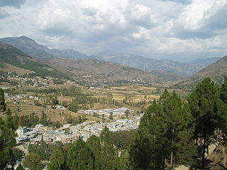
Battagram is a city and Union Council of Battagram District in Khyber Pakhtunkhwa Province of Pakistan. It is located at 34°41'N 73°1'E and has an altitude of 1038 metres.

Battagram is a tribal district in Hazara Division of Khyber Pakhtunkhwa province in Pakistan. The headquarter is Battagram, which is about 75 km from Mansehra. It was part of historic Yaghistan before 1965.

Thakot or Takot is a tribal town on the Indus River in Battagram District of Khyber Pakhtunkhwa, Pakistan. It is also one of twenty Union Councils of Battagram District, and one of twelve in Battagram Tehsil. Thakot is located midway between Battagram town in the south and Besham town in the north, at a distance of about 30 km from both.
Qila Tara Singh is a town and union council of Depalpur Tehsil in the Okara District of Punjab Province, Pakistan. It is located near Diaram, also a town near Depalpur.
Banna is a town, and one of twenty union councils in Battagram District in the Khyber Pakhtunkhwa province of Pakistan.
Ajmera is the capital city of Battagram District in Khyber Pakhtunkhwa Province of Pakistan.
Banian is a town, and one of twenty union councils in Battagram District in the Khyber Pukhtunkhwa of Pakistan. The place was named by Bania (caste) of Narrore, while they formerly ruled the Jirgah System Kingdom for centuries. It is located at 34°36'30N 73°3'15E and has an altitude of 1497 metres (4911 feet).
Kuza Banda is a town, and one of twenty union councils in Battagram District in Khyber Pakhtunkhwa province of Pakistan. It is located at 34°38'5N 73°2'30E and has an altitude of 1425 metres (4678 feet). It is linked with the union council town of Battagram, and also to Oghi Tehsil of Mansehra District, by Oghi road, which has been connected with the traditional silk route since ancient times.
Paimal Sharif is a town, that is one of twenty union councils in Battagram District in the Khyber Pakhtunkhwa Province of Pakistan.
Shumlai is a town, and one of twenty union councils in Battagram District, in Khyber Pakhtunkhwa province of Pakistan. It is located at 34°42'20N 73°7'0E and has an altitude of 1567 metres.
Trand is a town in Battagram District in Khyber Pakhtunkhwa province of Pakistan, one of 20 union councils in the district. It is located at 34°37'60N 72°58'60E and has an altitude of 1,303 metres (4278 feet).
Biari is a town, and one of twenty union councils in Battagram District in Khyber-Pakhtunkhwa province of Pakistan. It is located at 34°38'30N 73°24'0E and has an altitude of 1904 metres.
Pashto is a town, and one of twenty union councils in Battagram District of Khyber-Pakhtunkhwa, Pakistan.
Rashang is a village in Battagram District of Khyber-Pakhtunkhwa. It is located at 34°49'10N 73°7'30E at an altitude of 1,970 metres (6,460 ft).

Sakargah is a town, and one of twenty union councils in Battagram District in the Khyber Pakhtunkhwa Province of Pakistan.
Battagram is a town and union council of Charsadda District in Khyber Pakhtunkhwa province of Pakistan. It is located at 34°13'7N 71°37'33E and at an altitude of 300 meters. The town borders the village of Kharaki.
Monan is a village and union council of Jhelum District in the Punjab Province of Pakistan. It is part of Jhelum Tehsil, and is located at 32°57′0″N73°41′0″E and has an altitude of 229 metres (754 feet).
Kotla Faqir is a village and union council of Jhelum District in the Punjab Province of Pakistan. It is part of Jhelum Tehsil, and is located at 32°54'0N 73°41'0E with an altitude of 218 metres (718 feet).
Pandori is a village and union council of Jhelum District in the Punjab Province of Pakistan. It is part of Dina Tehsil, and is located at 33°6'0N 73°37'0E with an altitude of 271 metres (892 feet).
Karg is a Village Council in Battagram District of Khyber-Pakhtunkhwa.
References
- ↑ "Tehsils & Unions in the District of Battagram". National Reconstruction Bureau of Pakistan. Archived from the original on 2012-02-09.
- ↑ Location of Rajdhawari - Falling Rain Genomics
Administrative divisions of Battagram District | ||
|---|---|---|
| Capital | ||
| Tehsils | ||
| Union councils | ||
| Village Councils | ||
34°41′0″N73°6′0″E / 34.68333°N 73.10000°E
| | This Battagram District location article is a stub. You can help Wikipedia by expanding it. |