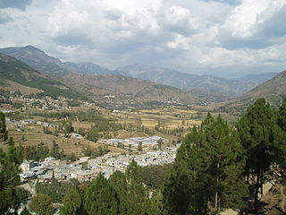
Battagram is a city and Union Council of Battagram District in Khyber Pakhtunkhwa Province of Pakistan. It is located at 34°41'N 73°1'E and has an altitude of 1038 metres.

Battagram is a tribal district in Hazara Division of Khyber Pakhtunkhwa province in Pakistan. The headquarter is Battagram, which is about 75 km from Mansehra. It was part of historic Yaghistan before 1965.

Thakot or Takot is a tribal town on the Indus River in Battagram District of Khyber Pakhtunkhwa, Pakistan. It is also one of twenty Union Councils of Battagram District, and one of twelve in Battagram Tehsil. Thakot is located midway between Battagram town in the south and Besham town in the north, at a distance of about 30 km from both.
Banna is a town, and one of twenty union councils in Battagram District in the Khyber Pakhtunkhwa province of Pakistan.
Banian is a town, and one of twenty union councils in Battagram District in the Khyber Pukhtunkhwa of Pakistan. The place was named by Bania (caste) of Narrore, while they formerly ruled the Jirgah System Kingdom for centuries. It is located at 34°36'30N 73°3'15E and has an altitude of 1497 metres (4911 feet).
Gijbori is a town, and one of twenty union councils of Battagram District in Khyber Pakhtunkhwa province of Pakistan. Also a part and a big village of Deshan Territory. It comprises many small villages. These include kandi is head village of this union council Torkhail clan is living here and this clan take important role in politics of this union council and also of all district.
Kuza Banda is a town, and one of twenty union councils in Battagram District in Khyber Pakhtunkhwa province of Pakistan. It is located at 34°38'5N 73°2'30E and has an altitude of 1425 metres (4678 feet). It is linked with the union council town of Battagram, and also to Oghi Tehsil of Mansehra District, by Oghi road, which has been connected with the traditional silk route since ancient times.
Paimal Sharif is a town, that is one of twenty union councils in Battagram District in the Khyber Pakhtunkhwa Province of Pakistan.
Rajdahri is a town, and one of twenty union councils in Battagram District in Khyber Pakhtunkhwa province of Pakistan. It is located at 34°40'60N 73°5'60E and has an altitude of 1408 metres. Khan of Garhi Habibullah is the "Wali of Rajdahri and Neeli-Shang" since last 11 generations.
Shumlai is a town, and one of twenty union councils in Battagram District, in Khyber Pakhtunkhwa province of Pakistan. It is located at 34°42'20N 73°7'0E and has an altitude of 1567 metres.
Trand is a town in Battagram District in Khyber Pakhtunkhwa province of Pakistan, one of 20 union councils in the district. It is located at 34°37'60N 72°58'60E and has an altitude of 1,303 metres (4278 feet).
Biari is a town, and one of twenty union councils in Battagram District in Khyber-Pakhtunkhwa province of Pakistan. It is located at 34°38'30N 73°24'0E and has an altitude of 1904 metres.
Pashto is a town, and one of twenty union councils in Battagram District of Khyber-Pakhtunkhwa, Pakistan.
Rashang is a village in Battagram District of Khyber-Pakhtunkhwa. It is located at 34°49'10N 73°7'30E at an altitude of 1,970 metres (6,460 ft).
Battagram Tehsil is an administrative subdivision (Tehsil) of the Battagram District in the Khyber Pakhtunkhwa province of Pakistan. It serves as the Tehsil headquarters and covers a total area of 300 square miles (780 km2). Battagram Tehsil merged into Pakistan as an administrative region before being raised to the status of a district in 1993. On October 8, 2005, a 7.6 magnitude earthquake in Kashmir badly affected the area.
Battagram is a town and union council of Charsadda District in Khyber Pakhtunkhwa province of Pakistan. It is located at 34°13'7N 71°37'33E and at an altitude of 300 meters. The town borders the village of Kharaki.
Garhi Daulatzai is a town and union council of Mardan District in Khyber Pakhtunkhwa province of Pakistan. It is located at 34°12'0N 72°10'0E and has an altitude of 294 metres.
Garhi Ismail Zai is a town and union council in Mardan District of Khyber-Pakhtunkhwa. It is located at 34°12'0N 72°10'0E and has an altitude of 294 metres.
Pidh is a village, union council, and administrative subdivision of Chakwal District in the Punjab Province of Pakistan. It is part of Choa Saidan Shah Tehsil.
Karg is a Village Council in Battagram District of Khyber-Pakhtunkhwa.
