Pashto is an Eastern Iranian language, spoken by the Pashtun tribes in Pakistan and Afghanistan.
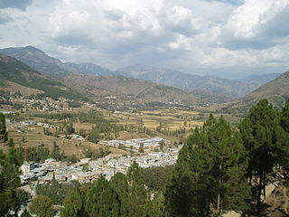
Battagram is a city and Union Council of Battagram District in Khyber Pakhtunkhwa Province of Pakistan. It is located at 34°41'N 73°1'E and has an altitude of 1038 metres.
Allai is a tehsil of Allai District in Pakistan's Khyber-Pakhtunkhwa province. It is home to the Allai Valley and district headquarters. Prince Muhammad Nawaz Khan Swati is the current "Chief of Allai Valley".
The Deshiwals, Deshi, Deshani or Deshan is Pashto speaking sub-tribe of the Mamylai section of Swati tribe residing on the eastern slopes of the Black Mountain of Hazara, had a fighting strength of over 1,000 armed men at the end of the 19th century, who saw action against the British. Deshi or Deshan is the name given to the country to north of Agror, and lying to the west of Nandhiar. It comprises a portion of the eastern slopes of the Black Mountain, a part of the Swati country, wooded spurs with intervening watercourses, on the banks of which are the villages. They are a united tribe, equally among themselves and when external danger threatens. They live in eight major villages, Sarkhaili Banda, Hotal Deshan, Kotgalla, Peshora, Shingli Payeen, Shingli bala, Gijbori, Sofian Torkhail, and in dozens of many small villages like. They migrated and changed their villages, after every five years before 1947. Thus no individual had any land ownership and all the land which they had, was a common wealth. So in case of any external invasion, they fought unitedly for the sake of their territory. The deadly earthquake October 8, 2005 affected this area badly. More than seventy people died and hundred of people injured. Property loss was also in billions. Kotgala and Hotal were the most affected villages.

Battagram is a tribal district in Hazara Division of Khyber Pakhtunkhwa province in Pakistan. The headquarter is Battagram, which is about 75 km from Mansehra city. It was part of historic Yaghistan before 1955. Later in 1955, It was merged into Pakistan and made part of neighboring Mansehra District with the status of Tehsil. It was officially separated from Mansehra District in July 1993 and was given the status of district. Battagram District was ruled by many different Khans, all belonging to the Swati tribe.

Banda Pir Khan is one of the 51 union councils of Abbottabad District in Khyber-Pakhtunkhwa, Pakistan.

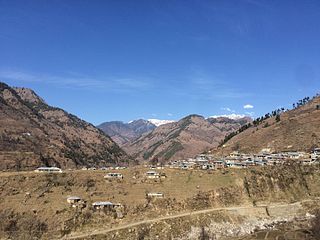
Thakot or Takot is a tribal town on the Indus River in Battagram District of Khyber Pakhtunkhwa, Pakistan. It is also one of twenty Union Councils of Battagram District, and one of twelve in Battagram Tehsil. Thakot is located midway between Battagram town in the south and Besham town in the north, at a distance of about 30 km from both.
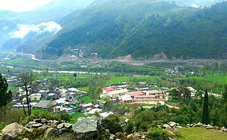
Hutal Batkul is a town, and one of twenty union councils in Battagram District in the Khyber Pakhtunkhwa province of Pakistan. The village is composed of eight small towns. Here is BHO High School and مدرسہ تعلیم القرآن. The source of most income of the people is from overseas. Abid khan 0594485891
Kuza Banda is a tribal town, and one of twenty union councils in Battagram District in Khyber Pakhtunkhwa province of Pakistan. It is located at 34°38'5N 73°2'30E and has an altitude of 1425 metres (4678 feet). It is linked with the union council town of Battagram, and also to Oghi Tehsil of Mansehra District, by Oghi road, which has been connected with the traditional silk route since ancient times.
Jambera is a town, and one of twenty union councils in Battagram District in the Khyber-Pakhtunkhwa province of Pakistan. It is situated on the bank of the river Indus and population of the union council is about 15,000. The union council of Jambera has three village councils: Jambera, Cheran, and Kund.There is also a cricket ground in jambera named Abbaseen cricket ground jambera and one volleyball ground(star ground). There is also public school in Jambira named star model public high school. Nawab Zada Abdul Ghafoor Khan is currently Member of District Council from Union Council Jambera. And Also chairman of Village council Jambera
Nawab Zada Abdul Ghafoor khan won 3 times Municipal election from Union council Jambera
Battagram Tehsil is an administrative subdivision (Tehsil) of the Battagram District in the Khyber Pakhtunkhwa province of Pakistan. It serves as the Tehsil headquarters and covers a total area of 300 square miles (780 km2). Battagram Tehsil merged into Pakistan as an administrative region before being raised to the status of a district in 1993. On October 8, 2005, a 7.6 magnitude earthquake in Kashmir badly affected the area.
Battagram is a town and union council of Charsadda District in Khyber Pakhtunkhwa province of Pakistan. It is located at 34°13'7N 71°37'33E and at an altitude of 300 meters. The town borders the village of Kharaki.
Bhanda Peeran(Urdu: بانڈه بيران) is a village and a part of Inayatabad Union Council of Mansehra District in the Khyber Pakhtunkhwa province of Pakistan.
Chappargram or Chapargram is a village of Battagram District in Khyber-Pakhtunkhwa province of Pakistan. It is part of Ajmera Union Council and lies within Battagram Tehsil and is located about four kilometres from the district headquarters Battagram along the Shahrah-e-Resham or silk route.
Shingli Bala is a village of Battagram District in Khyber-Pakhtunkhwa province of Pakistan. It is part of Gijbori Union Council and lies within Battagram Tehsil and is located about four kilometres from the district headquarters Battagram along the Karakoram Highway(Shahrah-e-Resham) or silk route, and opposite CPEC Bridge at Kas-Pul area.
Shingli Payeen is a village of Battagram District in Khyber-Pakhtunkhwa province of Pakistan. It is part of Peshora Union Council and lies within Battagram Tehsil and is located about Five kilometres from the district headquarters Battagram along the Shahrah-e-Resham or silk route.
Asharban is a Village Council in Battagram District of Khyber-Pakhtunkhwa.
Bojri is a Village Council in Battagram District of Khyber-Pakhtunkhwa.
Karg is a Village Council in Battagram District of Khyber-Pakhtunkhwa.
Kanai is a Village Council in Battagram District of Khyber-Pakhtunkhwa.
