Related Research Articles

The Western Slope is colloquial term generally understood to describe the part of the state of Colorado west of the Continental Divide. Bodies of water west of the Divide flow toward the Pacific Ocean; water that falls and flows east of the Divide heads east toward the Gulf of Mexico. The Western Slope encompasses about 33% of the state, but has just 10% of the state's residents. The eastern part of the state, including the San Luis Valley and the Front Range, is the more populous portion of the state.

The Shinwari is an ethnic Pashtun tribe of Afghanistan. Among the greatest poets of the Pashto language in the 20th century was the late Ameer Hamza Shinwari, also known as "Hamza Baba".

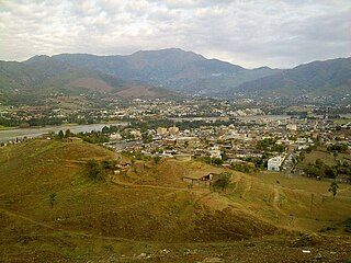
Mansehra is a city in the Khyber Pakhtunkhwa province of Pakistan and the headquarters of Mansehra District. It is the 71st largest city in Pakistan by population and the 7th largest city in the province.
Timergara is a city and the district headquarters of the Lower Dir District and temporary headquarter of newly established Central Dir District in Khyber Pakhtunkhwa Pakistan. Timergara city is located on the east bank of the Panjkora River. It lies at an altitude of 823 metres (2,700 ft). The town is the site of excavated graves of Indo-Aryans, dating from 1500 to 600 BC. On the west side of the Panjkora River is the excavated site of Balambat. The site has been occupied continuously since the time of the Indo-Aryans in 1500 BC. Discoveries included houses dating from 500 BC and fire altars, showing that the people followed early form Aryan religion which revolved around fire worshipping. The areas early political history is defined by the control of the Bactrians, Scythians and Hepthalites, and artifacts and ruins from these periods are found throughout the region. At the 1998 Census, the town had a population of 43,774. Most of the main city lies on the bank of the river Panjkora, which separates Balambat from the main city.

Torghar District formerly known as Kala Dhaka is a district in the Hazara Division of the Khyber Pakhtunkhwa province of Pakistan. It was officially separated from the Mansehra District in 2011 under Article 246 of the Constitution of the Islamic Republic of Pakistan.

The valley of Agror is located in the Hazara region of the Khyber-Pakhtunkhwa province of northern Pakistan. Its territory makes up Oghi Tehsil, an administrative unit of Mansehra District. Tanoli of Agror are ruling this area from generations. Agror is the Pashto speaking area where Tanoli speak pashto as their mother tongue.
Allai is a tehsil of Allai District in Pakistan's Khyber-Pakhtunkhwa province. It is home to the Allai Valley and district headquarters. Prince Muhammad Nawaz Khan Swati is the current "Chief of Allai Valley".
Bahali is a village and union council of the Mansehra District in Khyber-Pakhtunkhwa province of Pakistan. Bahali is part of Mansehra Tehsil and is located at the boundary area of the Mansehra district and the Abbottabad district, west from the Karakurram highway at Qalanderabad. It is a valley surrounded by mountains. It is inhabited by Turki, Tanolies, Awan, Gujjar, Syeds And Galye.
Karnol is a village and union council of Mansehra District in the Khyber-Pakhtunkhwa province of Pakistan. It is located at an altitude of 797 metres (2618 feet) lying in the south east of the district near to Abbottabad and the Kashmir frontier and lies in an area affected by the 2005 Kashmir earthquake. Ameer-Ullah Khan the elder son of Habibullah Khan I and grandson of Sa'adat Khan who was the first ruler of pakhli (1762-1780) under Durrani Empire & nominal Chief of Swatis founded this village.

The Outeniqua Mountains, named after the Outeniqua Khoikhoi who lived there, is a mountain range that runs a parallel to the southern coast of South Africa, and forms a continuous range with the Langeberg to the west and the Tsitsikamma Mountains to the east. It was known as Serra de Estrella to the Portuguese. The mountains are part of the Garden Route of South Africa.
Battagram Tehsil is an administrative subdivision (Tehsil) of the Battagram District in the Khyber Pakhtunkhwa province of Pakistan. It serves as the Tehsil headquarters and covers a total area of 300 square miles (780 km2). Battagram Tehsil merged into Pakistan as an administrative region before being raised to the status of a district in 1993. On October 8, 2005, a 7.6 magnitude earthquake in Kashmir badly affected the area.
Bhanda Peeran(Urdu: بانڈه بيران) is a village and a part of Inayatabad Union Council of Mansehra District in the Khyber Pakhtunkhwa province of Pakistan.
The valley of Tikri or Tikrai is situated in the present day Battagram District at the eastern slope of the famous Black Mountain, otherwise known as Tor Ghar or Kala Daka.
Kotgala is a village located in Battagram District, Pakistan. It is part of the Peshora union council. The population is approximately 5,000.
The Black Mountain (Tor Ghar), is located in the Hazara division of the Khyber Pakhtunkhwa province of Pakistan. Tor Ghar is a Pashto phrase which means Black (Tor) Mountain (Ghar). It is also called Kala Dhaka, which means the same as its Pushto name; in Hindko a local language spoken by the people of Tanawal and Agror which are located on eastern side of Tor Ghar. Tor Ghar lies to the east of the River Indus from Thakot to Darband. The total length of this mountain is about twenty five to thirty miles and its average height about 8,000 feet (2,400 m) feet above sea level. Machai Sar is the highest peak, and is 9,817 ft (2,992 m) above sea level. It ascends from the Indus basin at its southern end near the village of Kiara and goes up to its watershed near the village Baradar; then it runs north-east by north to the point on the crest known as Chitabat. From here the range runs due north, finally descending to the Indus by two large spurs, at the foot of the easternmost of which lies Thakot. The Indus, after passing Thakot, turns westward along the northern foot of the mountain until it washes the western of the two aforementioned spurs, when it takes a sharp bend to the south, and runs below and parallel to the western foot of this mountain range.
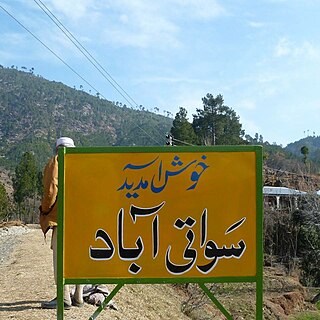
Swatiabad “سواتی آباد” is a village in Kathai union council, Tehsil Oghi, of Mansehra District in Khyber Pakhtunkhwa province of Pakistan. 9.2 km from main city of Oghi on Battal Road, It lies in an area affected by the 2005 Balkot earthquake. 34°31'42.35" N 73°06'04.19" E
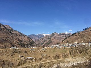
Dherai Bahader Khan is a small village in Kuza Banda, southern Battagram district, Khyber Pakhtunkhwa province, Pakistan. It is located at 34°38'9.51"N 73° 0'27.98"E, at an altitude of 1218 m, on the Oghi Battagram Road. The town was founded by Zaman Khan, father of Haji Bahader Khan, about 150 years ago. Residents belong to the Torkhel sub-tribe of the Deshan tribe of Swati.

Manglawar is an administrative unit, known as Union council of Tehsil Babuzai, of Swat District in the Khyber Pakhtunkhwa province of Pakistan and former capital of Kingdom of Swat. It is located at 34°48'30.7"N 72°25'50.0"E with an average altitude of 987 meters.
The British Baizai district is a bay about 20 miles long and 12 miles broad, which runs into the hills between the Paja and Malakand ranges at the extreme N.W. of the Yusufzai division of the Peshawur district. It is inhabited by Baizai, Swati, Utmankhel and Khattak, with some Mohmand, Rowanri, etc. The last of these claim to be Pathans, and there is no great family of khans in Baizai. On the fifth and 14 December 1849, Colonel Bradshaw led an expedition against those in British territory, in which he attacked and destroyed the villages of Sangao in British Baizai', and Palai Zormandai and Sherkhana in Swat Baizai. These operations were led against the Swatis, Ranizais and Uthmankhels of the Lundkhor tract. From the time of the annexation of the Punjab, the Swatis uniformly proved themselves bad neighbours to the British. They used the plains of Peshawar as hunting-grounds, as plunderers passed through Ranizai and plundered the plains of Hashnagar and Yusufzai. The Swatis harboured renegades, refugee criminals and internal malcontents, and took every opportunity of inciting British villages to violence.
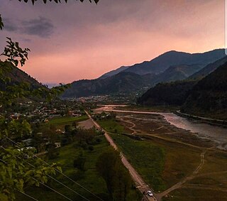
Shingli bala is a village of Battagram District in Khyber-Pakhtunkhwa province of Pakistan. It is part of Gijbori Union Council and lies within Battagram Tehsil and is located about four kilometres from the district headquarters Battagram along the Karakoram Highway(Shahrah-e-Resham) or silk route, and opposite CPEC Bridge at Kas-Pul area.