Waziristan is a mountainous region covering the North Waziristan and South Waziristan districts of the Pakistani province of Khyber Pakhtunkhwa. Waziristan covers around 11,585 square kilometres (4,500 sq mi) and is mainly populated by the Wazir Pashtun tribe, who speak the Waziri dialect of the Pashto language.

French Somaliland was a French colony in the Horn of Africa. It existed between 1884 and 1967, at which time it became the French Territory of the Afars and the Issas. The Republic of Djibouti is its legal successor state.

Bannu District is a district in the Bannu Division of the Khyber Pakhtunkhwa province of Pakistan. Its status as a district was formally recorded in 1861 during the British Raj.

North Waziristan District is a district of Khyber Pakhtunkhwa province in Pakistan. It is the northern part of Waziristan, a mountainous region of northwest Pakistan, bordering Afghanistan and covering 4,707 square kilometres (1,817 sq mi). The capital city of North Waziristan is Miranshah.

The Tirah campaign, often referred to in contemporary British accounts as the Tirah expedition, was an Indian frontier campaign from September 1897 to April 1898. Tirah is a mountainous tract of country in what was formerly known as Federally Administered Tribal Areas of Pakistan, now Khyber Pakhtunkhwa province.
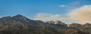
The Spīn Ghar or Safēd Kōh meaning both White Mountains, or sometimes meaning white mountain range, is a mountain range to the south of the Hindu Kush. It ranges from eastern Afghanistan into Khyber Pakhtunkhwa, Pakistan, and forms a natural border between the two areas. Its highest peak is Mount Sikaram on the Afghanistan–Pakistan border, which towers above all surrounding hills to 4,755 m (15,600 ft) above mean sea level. The lower hills are mostly barren and treeless, but pine grows on the main mountains that form the East Afghan montane conifer forests.
The Miranzai Valley, also Hangu, is a mountainous valley situated in the Kohat and Hangu districts in the North-West Frontier Province of Pakistan. It is made up of two valleys, draining from the southwest into the Kurram and northeast into the Kohat Tai. It is divided into upper and lower Miranzai. It extends from the Bangash and Orakzai hills to the Bangashs. It is 40 miles (64 km) in length and is 546 square miles (1,410 km2) in area. East of Hangu there are numerous smaller valleys; west of Hangu, consisting of all of the upper portion of the valley, there is a broad and open plain, bare of trees. There are many ravines in this and the surrounding area, with many inhabitants, predominantly the Bangash and Orakzai peoples.

The Turi or Torai are a tribe of the Pashtun people, inhabiting the Kurram Valley, in Kurram Agency in the Federally Administered Tribal Areas of Pakistan, with a smaller number living across the Durand line in the Paktia province of Afghanistan. They speak Pashto and are adherents of the Twelver Shia sect of Islam. Unlike the majority of Pashtun tribes, The Turis predominantly follow the Shia sect of Islam, because of this and other reasons and land history they are usually tensions between them and the Sunni Pashtun tribes; Mangal and Bangash tribe who also live in Kurram Valley.

Khyber District is a district in the Peshawar Division of the Khyber Pakhtunkhwa province of Pakistan. Until 2018, it was an agency of the erstwhile Federally Administered Tribal Areas. With the merger of FATA with Khyber Pakhtunkhwa in 2018, it became a district. It ranges from the Tirah valley down to Peshawar. It borders Nangarhar Province to the west, Orakzai District to the south, Kurram District to southwest, Peshawar to the east and Mohmand District to the north.
Orakzai Or Wrakzai are a Pashtun tribe native to the Orakzai Agency, parts of Kurram Agency, Khyber agency, located in Khyber Pakhtunkhwa province of Pakistan.
Kohat Division is one of the seven divisions in the Khyber Pakhtunkhwa province of Pakistan. It consists of five districts: Hangu, Karak, Kohat, Kurram, and Orakzai. According to the 2017 Census of Pakistan, the division had a population of 3,211,458, making it the third-least populous division in the province. Its area is 12,377 km2 (4,779 sq mi). Thus, it is also the fourth-largest division by area in the province. Kohat is the division's largest city and its namesake. Kohat city has a population of 220,000. The division borders Bannu Division to the south and west, Peshawar Division to the north and east, the province of Punjab to the east, and Afghanistan to the northwest. CNIC code of Kohat Division is 14.

Bannu Division is one of seven divisions in Pakistan's Khyber Pakhtunkhwa province. It consists of three districts: Bannu, Lakki Marwat, and North Waziristan. According to the 2017 Pakistani Census, the division had a population of 2,656,801, making it the least populous division in the province, but it spans 9,975 km2 (3,851 sq mi) of area, and this makes it the third-smallest division by area in the province. Lakki Marwat is the largest city of Bannu Division, with around 60,000 people, while the division's namesake and second-largest city is Bannu, with just under 50,000 people. The division borders Dera Ismail Khan Division to the south and west, Kohat Division to the north and east, and the province of Punjab, Pakistan to its east. CNIC code of Bannu Division is 11.
Kurram District is a district in the Kohat Division of the Khyber Pakhtunkhwa province of Pakistan. The name Kurram comes from the river Kwarma in Pashto which itself derives from the Sanskrit word Krumuḥ.
Kushalgarh is a village in the Kohat District of Khyber Pakhtunkhwa. It is the point at which the Indus River was bridged to permit the extension of the railway from Rawalpindi to the Miranzai and Kurram valleys.

The March of Verona and Aquileia was a vast march of the Holy Roman Empire in the northeastern Italian Peninsula during the Middle Ages, centered on the cities of Verona and Aquileia. Seized by King Otto I of Germany in 952, it was held by the Dukes of Bavaria; from 976 in personal union with the Duchy of Carinthia. The margravial regime ended with the advent of the Lombard League in 1167.

The Doon Valley is an unusually wide, long valley within the Sivalik Hills and the Lesser Himalayas, in the Indian states of Uttarakhand, Himachal Pradesh and Haryana. Within the valley lies the city of Dehradun, the winter capital of Uttarakhand state.
The Chamkani, is a sub-tribe of Ghoryakhel Pashtuns. According to Muhammad Hayat Khan, author of Hayat-i-Afghani Chamkani are descendants of Ibrahim Ghoria. They are also related to Mohmand, Daudzai and Khalil through their Sarbani descent.

Pewar its 16 km far from the capital city Parachinar of Kurram District, and one of the villages near to parachinar Khyber Pakhtunkhwa province of Pakistan. Pewar is situated on a neck of Pakistani territory south of Peshawar, that extends into Paktia Province of Afghanistan. It is the closest point in Pakistan to Kabul and borders on the Tora Bora region of Afghanistan. Turi, Bangash, Orakzai, Zazai, Mangal and Para Tsamkani are the major tribes in Pewar, Parachinar. Pewar is known for its fresh fruits, fresh vegetables and snowfall.

The Kurram Militia is a paramilitary regiment of the Frontier Corps of Pakistan. It was originally raised by the British in 1892 to operate in the North-West Frontier Province, and carried in that role following Pakistan's independence in 1947.
The Kabul Khel are a Waziri tribe in Pakistan. They are a subtribe of the Utmanzai. In the past, the Kabul Khel have fought multiple wars against the authorities of the British Raj.