This article needs additional citations for verification .(February 2024) |
Paind is a village near Shutrana which is in Punjab, India. It belongs to Patiala District. [1]
This article needs additional citations for verification .(February 2024) |
Paind is a village near Shutrana which is in Punjab, India. It belongs to Patiala District. [1]

Mandya is a city in the state of Karnataka. It is the headquarter of Mandya district and is located 45 kilometres (28 mi) from Mysore and 100 kilometres (62 mi) from Bangalore.
Aeolus Valley is a village in the Yallahs district of the Jamaican parish of Saint Thomas. Although there has been a recent wave of violence and murders, residents still say that the community is a wonderful place.
Lonar is a town and municipal council in Buldhana district of Vidarbha region of the Indian state of Maharashtra. The town is the headquarter of Lonar taluka and is located near Mehkar.

Karnal district is one of the 22 districts of Haryana, a state in North India which constitutes the National Capital Region (NCR) of the country. The city of Karnal is a part of the National Capital Region (NCR) and is the administrative headquarters of the district.
The Mysore plateau, also known as the South Karnataka plateau, is a plateau that is one of the four geographically unique regions of the Indian state of Karnataka. It has many undulations and is bounded on the west and south by the Western Ghats. Most of the river Kaveri flows through Karnataka in the Mysore Plateau. The average elevation in the region is between 600 and 900 meters. The plateau covers the districts of Bangalore, Bangalore Rural, Chamarajanagar, Hassan, Kodagu, Kolar, Mandya, Mysore and Tumkur.
Hirekeruru is a panchayat town in Haveri district in the Indian state of Karnataka. The name "the village of the big pond". The name is pronounced as "Hee ray kay roor".
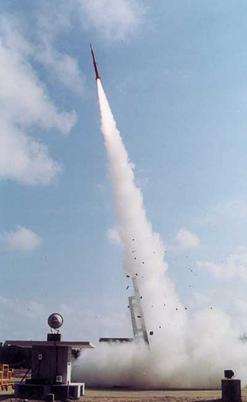
Thumba Equatorial Rocket Launching Station (TERLS) is an Indian rocket launching site established on 21 November 1963. Operated by the Indian Space Research Organisation (ISRO), it is located in Thumba, Thiruvananthapuram, which is near the southwestern tip of mainland India, very close to Earth's magnetic equator. It is currently used by ISRO for launching sounding rockets.

India uses only one time zone across the whole nation and all its territories, called Indian Standard Time (IST), which equates to UTC+05:30, i.e. five and a half hours ahead of Coordinated Universal Time (UTC). India does not currently observe daylight saving time.
Ummathoor is a village near Civil Station in the state of Kerala, India.
Banasihalli is a small village in Hosadurga Taluk of Chitradurga district, Karnataka state, India. It is around 15 km from Hosadurga. Population is around 1000 and agriculture is the main occupation. Coconut and Arecanut are main agricultural products. The place is surrounded by rocky mountains. Lingayat is the main caste of people. There is a government primary school for education. The place is well connected to Hosadurga and Chitradurga by buses.
Wadoda is a village, in Malkapur tehsil of Buldhana district, Maharashtra State, India. Nearby towns are Malkapur on west, Nandura on west.
Black Thunder Theme Park (P) Ltd is a theme park in Tamil Nadu, India. It is located on the National Highway (Mettupalayam-Ooty) on the foothills of Nilgiris. It is situated in Coimbatore city, 40 km north of the city and occupies an area of about 60 acres. The nearest airport is in Coimbatore and the nearest railway station is at Mettupalayam.
Ong River is a tributary of Mahanadi river. It flows across Odisha and joins Mahanadi 240 km (150 mi) upstream of Sonepur where Tel merges. The river rises at an elevation of 457 m (1,499 ft) and runs 204 km (127 mi) before it meets Mahanadi. It drains an area of about 5,128 km2 (1,980 sq mi).
Hampiholi is a village on the banks of river Malaprabha in Belgaum district, 14 kilometres (8.7 mi) from Ramdurga taluk in the southern state of Karnataka, India.
Jalikatti is a village in Belgaum district in the southern state of Karnataka, India.

Alwar State is a princely state of Naruka Rajputs with its capital at Alwar in India. Founded in 1770 CE by Pratap Singh Prabhakar, its reigning ruler, Maharaja Sir Tej Singh Prabhakar Bahadur, signed the accession to the Indian Union on 7 April 1949.
Raghavapur is a village in Nalgonda district in Telangana, India. It falls under Bibinagar mandal.

Meppadi is a village in the Indian state of Kerala. It is an extremely scenic hill station on the State Highway between Kozhikode and Ooty. The nearest city is Kalpetta, which is the headquarters of the Wayanad revenue district.

Karnal Division is one of the six divisions of Haryana, a state of India. It comprises the districts of Karnal, Panipat and Kaithal. It was announced in January 2017 and approved by the Haryana cabinet on 2 February 2017.

Sangod Legislative Assembly constituency is one of the 200 Legislative Assembly constituencies of Rajasthan state in India.
29°54′N76°06′E / 29.900°N 76.100°E
| | This article about a location in the Indian state of Punjab is a stub. You can help Wikipedia by expanding it. |