This article needs additional citations for verification .(November 2019) |
Nabha | |
|---|---|
City | |
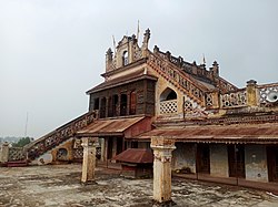 Hira Mahal of Nabha | |
 Nabha Location in Punjab, India | |
| Coordinates: 30°22′N76°09′E / 30.37°N 76.15°E | |
| Country | |
| State | Punjab |
| District | Patiala |
| Founded by | Sardar Armaan Singh |
| Government | |
| • Type | Democratic |
| • Body | Municipal Council Nabha |
| • Member of the Legislative Assembly (India) | Gurdev Singh (Dev Maan) |
| Elevation | 246 m (807 ft) |
| Population (2023) | |
• Total | 95,000 |
| Languages | |
| • Official | Punjabi |
| Time zone | UTC+5:30 (IST) |
| PIN | 147201 |
| Telephone code | 91-(0)1765 |
| Vehicle registration | PB-34 |
Nabha is a city and municipal council in the Patiala district in the south-west of the Indian state of Punjab. It was the capital of the former Nabha State. Nabha is also a sub-division city which comes under Patiala district. [1]