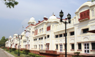
Patiala is a city in southeastern Punjab, northwestern India. It is the fourth largest city in the state and is the administrative capital of Patiala district. Patiala is located around the Qila Mubarak constructed by the Sidhu Jat chieftain Ala Singh, who founded the royal dynasty of Patiala State in 1763, and after whom the city is named.

Bathinda is a city and municipal corporation in Punjab, India. The city is the administrative headquarters of Bathinda District. It is located in northwestern India in the Malwa Region, 227 km (141 mi) west of the capital city of Chandigarh and is the fifth largest city of Punjab. Bathinda is known as the 'City of Lakes' due to the three artificial lakes adjacent to the now-closed Thermal power plant in the northern part of the city.

The Patiala and East Punjab States Union (PEPSU) was a state of India, uniting eight princely states between 1948 and 1956. The capital and principal city was Patiala. The state covered an area of 26,208 km². Shimla, Kasauli, Kandaghat and Chail also became part of the PEPSU.
Malerkotla is the district headquarters of Malerkotla district in the Indian state of Punjab. It was the seat of the eponymous princely state during the British Raj. The state acceded to the union of India in 1947 and was merged with other nearby princely states to create the Patiala and East Punjab States Union (PEPSU).
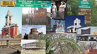
Hoshiarpur is a city and a municipal corporation in Hoshiarpur district in the Doaba region of the Indian state of Punjab. It was founded, according to tradition, during the early part of the fourteenth century. In 1809 it was occupied by the forces of Maharaja Karanvir Singh and was united into the greater state of Punjab in 1849.

Mahendragarh district is one of the 22 districts of Haryana state in northern India. The district occupies an area of 1,899 km² and has a population of 922,088 (2021census). District have 3 Sub-divisions : Narnaul, Mahendragarh and Kanina

Firozepur, is a city on the banks of the Sutlej River in Firozpur District, Punjab, India. After the Partition of India in 1947, it became a border town on the Indo-Pakistani border with memorials of India's freedom fighters.

Patiala district is one of the twenty three districts in the state of Punjab in north-west India.
Chamar is a dalit community classified as a Scheduled Caste under modern India's system of affirmative action. Historically subject to untouchability, they were traditionally outside the Hindu ritual ranking system of castes known as varna. They are found throughout the Indian subcontinent, mainly in the northern states of India and in Pakistan and Nepal.

Punjabi Hindus are an Indo-Aryan group who are adherents of Hinduism and identify linguistically, culturally, and genealogically as Punjabis. While Punjabi Hindus are mostly found in the Indian state of Punjab today, many have ancestry from the entire Punjab region, an area that was partitioned between India and Pakistan.

Mohali district, officially known as Sahibzada Ajit Singh Nagar district or SAS Nagar district, is one of the twenty three districts of Punjab, a state in north-west India. It was formed in April 2006 and is 18th district of Punjab, created next to Pathankot district. This district was carved out of areas falling in Ropar and Patiala District. It is situated next to the union territory of Chandigarh and Panchkula district of Haryana.

Bagnan I is a community development block that forms an administrative division in Uluberia subdivision of Howrah district in the Indian state of West Bengal.
According to the 2011 Census of India, Punjab, India has a population of around 27.7 million.

Punjab is a state in northern India. Forming part of the larger Punjab region of the Indian subcontinent, the state is bordered by the Indian states of Himachal Pradesh to the north and northeast, Haryana to the south and southeast, and Rajasthan to the southwest, by the Indian union territory of Chandigarh to the east, and by Jammu and Kashmir to the north. It is bordered by Punjab, a province of Pakistan to the west. The state covers an area of 50,362 square kilometres, 1.53% of India's total geographical area. It is the 20th-largest Indian state by area. With over 27 million inhabitants, Punjab is the 16th-largest state by population, comprising 23 districts. Punjabi, written in the Gurmukhi script, is the most widely spoken and official language of the state. The main ethnic group are the Punjabis, with Sikhs and Hindus as the dominant religious groups. The state capital is Chandigarh, a union territory and also the capital of the neighbouring state of Haryana. The five tributary rivers of the Indus River from which the region took its name are the Sutlej, Ravi, Beas, Chenab and Jhelum rivers; the Sutlej, Ravi and Beas rivers flow through the Indian Punjab.

Panjeta is a village located in the Ludhiana district of Punjab, India.
Bally Jagachha is a community development block that forms an administrative division in Howrah Sadar subdivision of Howrah district in the Indian state of West Bengal.
Amta II is a community development block that forms an administrative division in Uluberia subdivision of Howrah district in the Indian state of West Bengal.
Bagnan II is a community development block that forms an administrative division in Uluberia subdivision of Howrah district in the Indian state of West Bengal.

A Legislative Assembly election was held in the Indian state of Punjab on 4 February 2017 to elect the 117 members of the Punjab Legislative Assembly. The counting of votes was done on 11 March 2017. The ruling pre-election coalition was the alliance comprising the political parties Shiromani Akali Dal and Bharatiya Janata Party and led by Chief Minister Parkash Singh Badal. The voter turnout for the Punjab Assembly election was 77.2% The Indian National Congress led by former Chief Minister Captain Amarinder Singh defeated the ruling alliance and the newcomer Aam Aadmi Party.
Amargarh is a city in the Malerkotla district of Punjab state in India. It is located at main road which is nearly 60 kilometers far from patiala city. The City is administrated by Municipal Council. Presently, S.Manjinder Singh Bawa is the Municipal Councillor of the city.

