Patiala is a city in southeastern Punjab, northwestern India. It is the fourth largest city in the state and is the administrative capital of Patiala district. Patiala is located around the Qila Mubarak constructed by the Sidhu Jat Sikh chieftain Ala Singh, who founded the royal dynasty of Patiala State in 1763, and after whom the city is named.
Nabha is a city and municipal council in the Patiala district in the south-west of the Indian state of Punjab. It was the capital of the former Nabha State. Nabha is also a sub-division city which comes under Patiala district.

Punjab Province was a provincial colony of the British Raj, with its capital in the city of Lahore. Most of the Punjab region was annexed by the British EIC in April 1849 following the Second Anglo-Sikh War, and declared a province of British Colonial Rule, it was one of the last areas of the Indian subcontinent to fall under British control. In 1858, the Punjab, along with the rest of the Subcontinent, came under the direct rule of the British Crown. It had an area of 358,354.5 km2.

Patiala district is one of the twenty three districts in the state of Punjab in north-west India.
Dhanaula is a city and a municipal council in Barnala district in the state of Punjab, India. Situated 18 km west of Sangrur, Dhanaula lies on the Sangrur-Barnala road. It is about 12 km from Barnala. Dhanaula was founded by Gurditta, eldest son of Taloka, in 1718. It was the capital of the erstwhile Princely State of Nabha until 1755 when Raja Hamir Singh founded Nabha town and made it the capital of the state. He also built a fort which now houses the police station of Dhanaula. A temple of Hanuman exists here. It is said that a man was digging a ditch and found an idol of Hanuman. A temple was constructed at that place, the idol was placed there, and the people began to worship it. Dhanaula is a town of temples.

East Punjab was a province and later a state of India from 1947 until 1966, consisting of the parts of the Punjab Province of British India that went to India following the partition of the province between India and Pakistan by the Radcliffe Commission in 1947. The mostly Muslim western parts of the old Punjab became Pakistan's West Punjab, later renamed as Punjab Province, while the mostly Hindu and Sikh eastern parts went to India.
Amloh is a city, sub-district and municipal council in Fatehgarh Sahib district in the state of Punjab, India. It is located near the industrial town of Mandi Gobindgarh.
Bagrian is a village located in Sangrur District, in Punjab, India which has a significant place in Sikh history. Now Called it by Bagrian Haveli name.
Khanna is a city and a municipal council in the Ludhiana district of the Indian state of Punjab. It is well known for being Asia's largest grain market. It is a city which centers a national highway and buildings settled around a web of roads descending from National Highway to various State Highways to different Directions. It has a huge market place which attracts customers from all around the area, namely Guru Amardas Market.

Prem Parkash is a writer from Punjab, India. He "is one of the major short story writers in post-1947 East Punjabi literature." He is also known as Prem Parkash Khannvi.
Malaudh was a Cis-Sutlej Phulkian princely state of India till 1846, after which it was merged into the Ludhiana District by the British when they annexed the territories around Ludhiana. The town of Malaudh, or Maloud, is situated at a distance of about 40 kilometres from Ludhiana on the Ludhiana-Malerkotla Road and is linked by approach road kup-payal road though village Rorian which is now part of it as Nagar Panchayat. It lies on 75°- 56' Longitude and 30° – 38' Latitude. Malaudh is a very ancient place which was known as Malla Udey or rise of the Mallas with whom Multan or Mallustan is associated and later got corrupted to Malaudh. There was a The Loharan about 1 kilometer on the southern side which has now disappeared. Malaudh has a government high school (co-educational), middle school for girls and a primary school for boys, a post office, primary health centre and a veterinary dispensary. Malaudh became a part of the Ludhiana District when it was formed out of the territories annexed by the British in 1846.

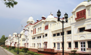
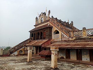
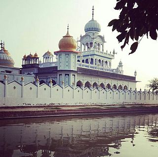
Nabha State, with its capital at Nabha, was one of the Phulkian princely states of Punjab during the British Raj in India. Nabha was ruled by Jatt Sikhs of the Sidhu clan.
Punjab is home to 2.3% of India's population; with a density of 551 persons per km2. According to the provisional results of the 2011 national census, Punjab has a population of 27,743,338, making it the 16th most populated state in India. Of which male and female are 14,639,465 and 13,103,873 respectively. 32% of Punjab's population consists of Dalits. In the state, the rate of population growth is 13.9% (2011), lower than national average. Out of total population, 37.5% people live in urban regions. The total figure of population living in urban areas is 10,399,146 of which 5,545,989 are males and while remaining 4,853,157 are females. The urban population in the last 10 years has increased by 37.5%. According to the 2011 Census of India, Punjab, India has a population of around 27.7 million.

Sangrur district is in the state of Punjab in northern India. Sangrur city is the district headquarters. It is one of the five districts in Patiala Division in the Indian state of Punjab. Neighbouring districts are Malerkotla (north), Barnala (west), Patiala (east), Mansa (southwest) and Fatehabad (Haryana) and Jind (Haryana) (south).
Ranbir Pura is a small village in Patiala District in Punjab, India. It is near the Bhakhra Canal on the roads to Sangrur and Nabha. This village has two different names. The village land was given to farmers by Maharajah Patiala's brother. Any brother of a king was called "Kaurji" and this gives the village its name - Kaurji Wala. The village's second name is Ranbir Pura. It is about 10 km from the city of Patiala. The village has one gurdwara.
Religion in the Punjab in ancient history was characterized by Hinduism and later conversions to Jainism, Buddhism, Islam, Sikhism and Christianity; it also includes folk practices common to all Punjabis regardless of the religion they adhere to. Such practices incorporate local mysticism, including ancestral worship and worship of local saints of all faiths.
Sidhuwal is a village on the road Patiala Bhadson - approximately six kilometres from Patiala in Patiala tehsil in the Patiala district of the state of Punjab in northwest India. It is located 6 km towards North from District headquarters Patiala and 66 km from State capital Chandigarh. The village is located at the banks of Bhakra Main Line Canal. The total geographical area of the village is 644 hectares. Jasso Wal, Prem Nagar, Ranjit Nagar, Ucha Gaon, Anand Nagar are the nearby Villages to Sidhuwal. Sidhu was is surrounded by Sanour Tehsil towards the East, Nabha Tehsil towards the west, Bhuner Heri Tehsil towards the South, Ghana Tehsil towards the East. Patiala, Sirhind Fatehgarh Sahib, Gobindgarh, Nabha are the nearby Cities to Sidhuwal.
Borawal (ਬੋੜਾਵਾਲ) also in records written as Borewal is a village in Budhlada tehsil of Mansa district in the Indian state of Punjab. It is on Budhlada - Bhikhi road. The village has a very large pond, three gurdwaras, and C-pet camp. Welfare clubs such as U Meed and Saheed Udam Singh are present.
Nabha Dass was a saint, theologian and author of the Bhaktamal. In this sacred scripture, Nabha Das wrote the life history of almost every saint ranging from the Satya Yuga to the Kali Yuga age. Nabha Dass wrote ‘Bhagatmal’ in 1585. Nabha Dass, a saint belonging to the tradition of Ramananda. On his birthday 8 April, millions of followers remember him and his resolve to work for humanity.
Punjab State Highway 12A, commonly referred to as SH 12A, is a state highway in the state of Punjab in India. The route of this state highway is from Mohali to Bhikhi in the state of Punjab. The total length of the highway is 142 kilometres.

