Pallivasal

Last updated

Pallivasal
Village
Pallivasal estate munnar.jpg
India Kerala location map.svg
Red pog.svg
Pallivasal
Location in Kerala, India
India location map.svg
Red pog.svg
Pallivasal
Pallivasal (India)
Coordinates: 10°03′42″N77°03′33″E / 10.0616500°N 77.059030°E / 10.0616500; 77.059030 Coordinates: 10°03′42″N77°03′33″E / 10.0616500°N 77.059030°E / 10.0616500; 77.059030
CountryFlag of India.svg  India
State Kerala
District Idukki
Area
  Total33.89 km2 (13.09 sq mi)
Population
 (2011)
  Total10,875
  Density320/km2 (830/sq mi)
Languages
  Official Malayalam, English [1]
  Spoken Malayalam,Tamil
Time zone UTC+5:30 (IST)
Vehicle registration KL-68

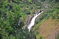
Pallivasal is a village in Idukki district in the Indian state of Kerala. [2]

Contents

The first hydro-electric project in Kerala was established at Pallivasal during the reign of Maharajah Sree Chithira Thirunal Balarama Varma. [3]

Pallivasal project

The Pallivasal electric project was commissioned in 1940. The Kerala electricity transmission system also emerged in 1940 with a 66 kV line from Pallivasal to Thiruvananthapuram. Eight substations were commissioned in 1940.

Demographics

As of 2011 Census, Pallivasal had population of 10,875 which constitutes 5,417 males and 5,458 females. Pallivasal village has an area of 33.89 km2 (13.09 sq mi) with 2,726 families residing in it. The average sex ratio was 1007 lower than state average of 1084. In Pallivasal, 9.4% of the population was under 6 years of age. Pallivasal had an average literacy of 90.6% higher than the national average of 74% and lower than state average of 94% ; male literacy was 94.5% and female literacy was 86.8%. [4]

Related Research Articles

<span class="mw-page-title-main">Peermade</span> Hill station in Kerala, India

Peermade, also spelt Peerumedu is a village, Grama Panchayat and hill station in the state of Kerala, India. It lies 915 metres (3,002 ft) above sea level in the Western Ghats (Sahyadri) about 85 kilometres (53 mi) east of Kottayam on the way to Thekkady through the nearby city of Kanjirappally.

<span class="mw-page-title-main">Devikulam</span> Village in Kerala, India

Devikulam is a Grama Panchayat and small hill station of about 8 kilometres (5.0 mi) from Munnar in the Idukki District of Kerala State, India. It lies 1,800 metres (5,900 ft) above sea level.

<span class="mw-page-title-main">Kumily</span> Plantation Town in Kerala, India

Kumily also spelt as Kumaly is a revenue village and Gram Panchayat in the Idukki district of Kerala. It is a town in Cardamom Hills near Thekkady and Periyar Tiger Reserve. Kumily is a gateway town into Kerala from Tamil Nadu.

<span class="mw-page-title-main">Udumbanchola</span> Village/Taluk in Kerala, India

Udumbanchola is a taluk in Idukki district of Kerala state in India. This is in the high ranges. Nedumkandam is the major town and capital of Udumbanchola taluk. Mathikettan Shola National Park is located in Udumbanchola.

<span class="mw-page-title-main">Kuttampuzha</span> Village in Kerala, India

Kuttampuzha is a village and gram panchayat in Ernakulam district in the Indian state of Kerala. Situated 71km east of Kochi, Kuttampuzha panchayat is home to the 17.7% of total area of the Ernakulam District.

Anaviratty is a village in Idukki district in the Indian state of Kerala.

<span class="mw-page-title-main">Ayyappancoil</span> Village in Kerala, India

Ayyappancoil, also spelt Ayyappankovil is a village in newly formed Idukki taluk in Idukki district in the Indian state of Kerala. It is highly noted for the newly constructed suspension bridge with a length of 200 meters and the old historic Sastha temple on the banks of Periyar river.

Chakkupallam is a Grama Panchayat and Village in Idukki district in the Indian state of Kerala. The administrative capital(Panchayat Office) and village center of Chakkupallam Grama Panchayat is Anakkara, located on Kumily-Munnar state highway. The town has a large church, built in 2000.

<span class="mw-page-title-main">Chathurangapara</span> Village in Kerala, India

Chathurangapara is a village in Idukki district in the Indian state of Kerala. The village is part of Udumbanchola and Senapathy Panchayats.

<span class="mw-page-title-main">Chinnakanal</span> Village in Kerala, India

Chinnakanal is a village in Idukki district in the Indian state of Kerala. The waterfalls here are popularly known as Power House Waterfalls. Arikomban is a famous elephant that lived in Chinnakanal.

<span class="mw-page-title-main">Karunapuram</span> Village in Kerala, India

Karunapuram is a village in Idukki district in the Indian state of Kerala.

Kunchithanny is a village situated in the Idukki district in the Indian state of Kerala. Located on the banks of the river Muthirappuzha, this village is home to people from different parts of the state of Kerala.

<span class="mw-page-title-main">Poopara</span> Village in Kerala, India

Poopara is a village in Idukki district in the Indian state of Kerala. It is located in the cardamom-growing region of Kerala, and also houses a number of tea and coffee plantations. The place also intersects the Munnar - Kumily state highway (SH-19) and Kochi - Dhanushkodi national highway (NH-49). The Anayirankal reservoir is 4 km up the road from Poopara.

<span class="mw-page-title-main">Rajakumari, Idukki district</span> Village in Kerala, India

Rajakumari is a village in Idukki district in the Indian state of Kerala.

Santhanpara is a village in Idukki district in the Indian state of Kerala.

Upputhode is a village in Idukki district in the Indian state of Kerala.

Keezhanthoor is a village in Idukki district in the state of Kerala, India. The village is in the western ghats and is known for growing apples. A Mariyamman Temple and a Vinayagar Temple are the places of devotion

<span class="mw-page-title-main">Kottakamboor</span> Village in Kerala, India

Kottakamboor is a village in Devikulam taluk of Idukki district in the state of Kerala, India.

Mlappara is a village in Idukki district in the state of Kerala, India.

<span class="mw-page-title-main">Devikulam taluk</span> Tehsil in Kerala, India

Devikulam taluk is one of the 5 taluks in Idukki district of Indian state of Kerala. Devikulam taluk comprises 13 villages.

References

  1. "The Kerala Official Language (Legislation) Act, 1969" (PDF).
  2. "Census of India : Villages with population 5000 & above". Registrar General & Census Commissioner, India. Archived from the original on 8 December 2008. Retrieved 10 December 2008.
  3. "Munnar". Archived from the original on 18 January 2014. Retrieved 21 June 2012.
  4. Kerala, Directorate of Census Operations. District Census Handbook, Idukki (PDF). Thiruvananthapuram: Directorateof Census Operations,Kerala. p. 52,53. Retrieved 14 July 2020.