Nunukan Regency is a regency of North Kalimantan Province in Indonesia. Nunukan Regency shares international borders with the Malaysian states of Sabah to the north and Sarawak to the west, and inter-regency borders with Tana Tidung Regency and Malinau Regency to the south. The regency covers an area of 14,247.50 km2 and it had a population of 140,841 at the 2010 census and 199,090 at the 2020 census. The official estimate as at mid 2022 was 208,303.

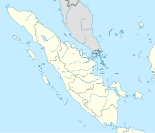
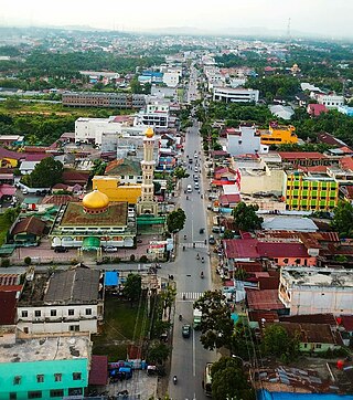
Padangsidempuan is a city in North Sumatra, Indonesia, and the former capital of South Tapanuli Regency, which surrounds the city. It has an area of 159.28 km² and a population of 178,818 people at the 2000 census, which rose to 191,554 in the 2010 census and 225,105 at the 2020 Census.

Pandeglang Regency is a regency of Banten province, Indonesia. It is mainly located on the west and south coasts of the island of Java, and is the most westerly regency on Java Island, but it also includes a number of offshore islands such as Panaitan, Deli and Tinjil. The regency has an area of 2,746.81 km2, and an population at the 2010 Census of 1,149,610, rising to 1,272,687 at the 2020 Census; the official estimate as at mid 2022 was 1,307,090. The regency seat is the town of Pandeglang.

Tanjung Balai, formerly known as Tanjung Balai-Asahan is a city in North Sumatra province, Indonesia, on the estuary of the Asahan River. It has an area of 60.52 square kilometers (23.37 sq mi) and the sixth largest kota (urban) population in North Sumatra with 154,445 inhabitants in the 2010 census and 176,027 at the 2020 Census. The town has a ferry terminal with services to Port Klang, Malaysia, and the city-island of Singapore.

Tebing Tinggi Deli or more commonly simply Tebing Tinggi is a city near the eastern coast of Northern Sumatra, Indonesia. It has an area of 38.44 km2 and a population at the 2010 Census of 145,180, which grew to 172,838 at the 2020 Census; the official estimate as at mid 2022 was 177,785. Tebing Tinggi is an enclave within Serdang Bedagai Regency, which surrounds it on all sides, and contains a kecamatan (district) bordering the city which is also named Tebing Tinggi.

Subulussalam is a city in the south of Aceh province of Indonesia. It is located inland on the island of Sumatra. On 2 January 2007, the provincial government of Aceh declared Subulussalam to be an independent city as a result of the administration being separated from that of Aceh Singkil Regency. of which it was formerly a part. It is located at 2°38′32″N98°00′15″E. It covers an area of 1,391 km2, and it had a population of 67,446 at the 2010 Census and of 90,751 at the 2020 Census; the official estimate as at mid 2022 was 95,199. As a result, Subulussalam is the most sparsely-populated city in Indonesia, with a population density of only 68 people per km2.
Rantauprapat is a town in North Sumatra province of Indonesia and it is the seat (capital) of Labuhan Batu Regency. Rantauprapat is also a village within the district of Rantau Utara. It consists of 3 main roads. A number of citizens move to larger cities like Medan in search for more job opportunities and/or universities. A large river named the Bilah River runs through the town, which had 140,778 inhabitants at the 2010 Census, 170,462 at the 2020 Census, and 175,960 according to the official estimates as at mid 2022.

Samosir Regency is an inland regency in North Sumatra. The regency covers a land area of 1,444.25 square kilometres, including the whole of Samosir Island in the inland sea of Lake Toba. It had a population of 119,653 at the 2010 census and 136,441 at the 2020 Census; the official estimate for mid 2022 was 139,337. Its seat is the town of Pangururan.

Simalungun Regency is a regency in North Sumatra, Indonesia. Its seat was formerly at Pematangsiantar, but this city was in 1986 separated from the Regency and made into an independent city (kota), although it remains geographically surrounded by the regency, whose new administrative seat is at Raya. The regency now covers an area of 4,372.5 square kilometres, and at the 2010 census it had a population of 817,720; at the 2020 Census this had risen to 990,246, of whom 497,314 were male and 492,932 were female; the official estimate as at mid 2022 was 1,021,615.

Yapen Islands Regency is a regency (kabupaten) in Papua Province of eastern Indonesia. It covers an area of 2,432.49 km2 (939.19 sq mi), and had a population of 82,951 at the 2010 Census and 112,676 at the 2020 Census. The official estimate as at mid 2021 was 114,210. It comprises an archipelago which lies in Cenderawasih Bay off the north coast of Western New Guinea.

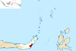
Bantaeng Regency is a regency of South Sulawesi Province in Indonesia. It covers an area of 395.83 km2 and had a population of 176,984 at the 2010 Census, rising to 196,716 at the 2020 Census. The official estimate as at mid 2021 was 197,886. The administrative centre is the town of Bantaeng, which lies on the south coast of the southern peninsula of Sulawesi island.

The Pangkajene and Islands Regency, is a regency of South Sulawesi Province of Indonesia. The regency lies primarily on the mainland of Sulawesi's southern peninsula, but also includes the Spermonde Islands off the west coast of that peninsula, as well as other small islands further west and southwest. The principal town lies at Pangkajene on Sulawesi, but there are a series of further small towns like Lejang, Labakkang, Bonto-Bonto and Segeri proceeding northwards from Pangkajene along the Trans-Sulawesi Highway. The total land area is 1,112.29 km2, and the population was 305,737 at the 2010 Census and 345,775 at the 2020 Census; the official estimate as at mid 2021 was 348,230.
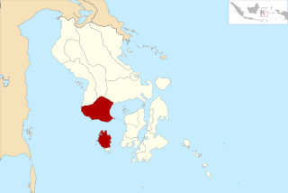
Bombana Regency is a regency of Southeast Sulawesi Province of Indonesia. It consists of part of the southeast peninsula of Sulawesi, together with most of the substantial offshore island of Kabaena to the south. It covers an area of 3,316.16 km2, and had a population on 139,235 at the 2010 Census and 150,706 at the 2020 Census; the official estimate as at mid 2021 was 151,910. The administrative centre lies at the town of Rumbia.
Buton Regency is a regency of Indonesia's Southeast Sulawesi Province, lying entirely on Buton Island. Until 2014 it had an area of 2,681.22 km2, and a population estimated at 276,944. However, in 2014 it was divided into three regencies, with two new regencies being cut out of it; the residual area now is 1,648.04 km2, and the districts in that area contained a population of 94,388 at the 2010 Census while the 2020 Census produced a total of 115,207; the official estimate as at mid 2021 was 117,040.

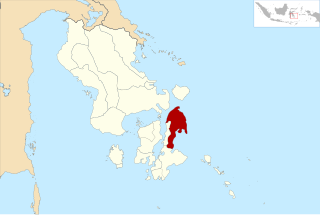
Kolaka Regency is a regency of Southeast Sulawesi Province, Indonesia. It covers an area of 2,958.69 km2 and had a population of 208,817 at the 2010 Census, rising to 237,587 at the 2020 Census. The principal town lies at Kolaka.
North Buton Regency is a regency of Indonesia's Southeast Sulawesi Province, which was separated from Buton Regency in accordance with Indonesia's Law Number 14 of 2007. The area of the regency, which covers the north part of Buton Island, is 1,923.03 km2. Its population was 54,736 at the 2010 Census and 66,653 at the 2020 Census; the official estimate as at mid 2021 was 67,714. The principal town lies at Buranga.

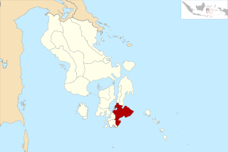
South Konawe Regency is a regency of Southeast Sulawesi Province, Indonesia. It covers an area of 4,200.89 km2 and had a population of 264,587 at the 2010 Census and of 308,524 at the 2020 Census. The official estimate as at mid 2021 was 312,674. The administrative centre is in the town of Andoolo.

The Banggai Archipelago is a group of islands, which are located at the far eastern end of Central Sulawesi, Indonesia. It makes up a regency (kabupaten) of Central Sulawesi Province of Indonesia, created in 1999 by splitting the existing Banggai Regency into a new Banggai Regency situated on the mainland of Sulawesi and a Banggai Islands Regency then comprising the entire archipelago. In December 2014 a further splitting of the Regency was the removal of the more southerly seven districts to form a new Banggai Laut Regency.
East Bolaang Mongondow Regency is a regency of North Sulawesi Province of Indonesia. It covers an area of 910.18 sq km and had a population of 63,654 at the 2010 Census, rising to 87,241 at the 2020 Census. The principal town lies at Tutuyan.

South Buru Regency is a regency of Maluku, Indonesia. It was created on 24 June 2008 by being split off from the existing Buru Regency. It is located on the island of Buru, of which it comprises the southern 40%. The Regency covers an area of 5,060 km2, and it had a population of 53,671 at the 2010 Census, rising to 75,410 at the 2020 Census; the official estimate as at mid 2022 was 77,287. The principal town lies at Elfule in Namrole District.