Parappa (Kasaragod)

Last updated

Parappa
Village, Block Panchayat
India Kerala location map.svg
Red pog.svg
Parappa
Location in Kerala, India
India location map.svg
Red pog.svg
Parappa
Parappa (India)
Coordinates: 12°22′17″N75°14′42″E / 12.3714°N 75.2450°E / 12.3714; 75.2450
CountryFlag of India.svg  India
State Kerala
District Kasaragod
Taluk Vellarikundu
Government
  Type Panchayati raj (India)
  Body Block Panchayat
Area
  Total40.22 km2 (15.53 sq mi)
Population
 (2011)
  Total14,137
  Density350/km2 (910/sq mi)
Languages
  Official Malayalam, English
Time zone UTC+5:30 (IST)
PIN
671533
Telephone code04672
Vehicle registration KL-79

Parappa is a village in Vellarikundu taluk of Kasaragod district and a block panchayat of the same name in the Indian state of Kerala. [1] [2]

Contents

Location

Parappa is located 7 km west of Vellarikundu on Odayanchal-Cherupuzha road, 24 km east of Kanhangad and 44 km south east of District headquarters Kasaragod.

Administration

Local bodies in Kasaragod district Local Self Governance in Kasaragod District.svg
Local bodies in Kasaragod district

Parappa is a village in Balal Grama Panchayat. The Parappa Block Panchayat consists of 7 Grama Panchayats, including Balal, East Eleri, Kallar, Kinanoor-Karindalam, Kodom-Belur, Panathady and West Eleri. [3] Parappa village is politically a part of Kanhangad (State Assembly constituency) which belongs to Kasaragod (Lok Sabha constituency). [4]

Demographics

As of 2011 Census, Parappa village had total population of 14,137 which constitutes 6,834 males and 7,303 females. Parappa village spreads over an area of 40.22 km2 (15.53 sq mi) with 3,463 families residing in it. The sex ratio of Parappa was 1068 lower than state average of 1084. Population in the age group 0-6 was 1,542 (10.9%) where 793 are males and 749 are females. Parappa had overall literacy of 88.3%, lower than state average of 94%. Male literacy stands at 92.1% and female literacy was 84.8%. [5]

Related Research Articles

<span class="mw-page-title-main">Kanhangad</span> Municipality in Kerala, India

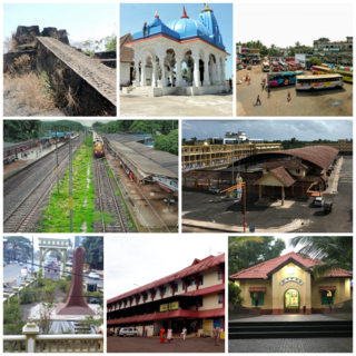
Kanhangad is a town, located in the Kasaragod District, state of Kerala, India.

<span class="mw-page-title-main">Udma</span> Census Town in Kerala, India

Udma is a census town in Kasaragod district in the Indian state of Kerala.

<span class="mw-page-title-main">Cherupuzha, Kannur</span> Town in Kerala, India

Cherupuzha is a town in Kannur district, Kerala, India. It is the headquarters of the Cherupuzha Panchayat which is a special grade panchayat in Kerala.

<span class="mw-page-title-main">Badiyadka</span> Town in Kerala, India

Badiyadka officially known as "Badiadka" is a town and gram panchayat in the Kasaragod district, state of Kerala, India.

Balal is a village and a Grama Panchayat in Kasaragod district in the state of Kerala, India.

Chittarikkal is a town in Vellarikundu Taluk in Kasaragod district in the state of Kerala, India. It is also a ward of the East Eleri grama panchayat.

<span class="mw-page-title-main">Karadka</span> Village in Kerala, India

Karadka is a village, block panchayat and grama panchayat in Kasaragod district in the state of Kerala, India.

Karindalam is a village in Kasaragod district in the state of Kerala, India.

Kinanoor or Kinavoor is an ancient Village capital situated in Sahya Hill area of Kasaragod district in the state of Kerala, India.It is situated between Nileshwar and Parappa.

Meenja is a grama Panchayat in Manjeshwaram Taluk of Kasaragod district in the state of Kerala, India. It consists of 7 revenue villages. Kaliyoor, Koliyoor, Talakala, Meenja, Kadambar, Moodambail and kuloor. & more beautiful village also kuloor

<span class="mw-page-title-main">Hosdurg taluk</span> Tehsil in Kerala, India

Hosdurg is one of four taluks that constitute the Kasaragod District, Kerala. Others are Kasaragod, Manjeshwaram and Vellarikundu taluks. In the north, it borders Kasaragod taluk; in south, the Kannur District; in the east, Vellarikundu taluk; and in the west, the Arabian sea. With an area of 900.3 km2, it was the smaller of the two taluks. Then Hosdurg bifurcated into Vellarikund and Hosdurg taluks in 2013 for ease of administration. Kanhangad and Nileshwaram are the municipalities within the taluk. Hosdurg is a kilometer south of Kanhangad town, the latter being the taluk headquarters. Other major settlements include Trikarpur, Cheruvathur and Udma. Bekal Fort tourism is situated in the taluk.

<span class="mw-page-title-main">Pallikkara, Bekal</span> Village in Kerala, India

Pallikkara is a census town and a grama panchayat in Hosdurg Taluk of Kasargod district in the state of Kerala, India. This place was once famous for its Tobacco plants until the late 1980s and the Historical landmark Bekal Fort lies in this Village. A beach park near to the fort also attracts tourists to this place.

<span class="mw-page-title-main">Vellarikundu</span> Town in Kerala, India

Vellarikundu is a town and taluk headquarters in the Hill range of Kasaragod District in the state of Kerala. Vellarikundu is located between Odayanchal and Chittarikkal on Odayanchal-Cherupuzha Road.

Mugu is a village in Manjeshwaram Taluk of Kasaragod district in Kerala, India.

Adoor is a village in Kasaragod district in the Indian state of Kerala. Adoor is located 38 km east of Kasaragod town and 7 km away from State Highway 55 or Cherkala-Jalsoor road.

<span class="mw-page-title-main">Kallar (Kasaragod)</span> Village in Kerala, India

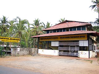
Kallar is a village in Kasaragod district in the Indian state of Kerala. Kallar is located on Kanhangad-Panathur road of 40 km south east of Kasaragod town and 27 km north east of Kanhangad.

Bela is a village in Kasaragod taluk of Kasaragod district in Indian state of Kerala.

Kolthur is a village in Kasaragod taluk of Kasaragod district in Indian state of Kerala.

Belur is a village in Vellarikundu taluk of Kasaragod district in Kerala, India.

Thimiri is a village in Hosdurg taluk of Kasaragod district in Kerala state, India. Thimiri is located 3 km east of Cheruvathur on Cheruvathur-Cheemeni road.

References

  1. "Taluk Offices" . Retrieved 24 August 2021.
  2. "Census of India : Villages with population 5000 & above". Registrar General & Census Commissioner, India. Archived from the original on 8 December 2008. Retrieved 10 December 2008.
  3. "Administrative divisions of Kasaragod district". Official website of Kasaragod district. Retrieved 12 September 2020.
  4. "Assembly Constituencies - Corresponding Districts and Parliamentary Constituencies" (PDF). Kerala. Election Commission of India. Archived from the original (PDF) on 4 March 2009. Retrieved 18 October 2008.
  5. Kerala, Directorate of Census Operations. District Census Handbook, Kasaragod (PDF). Thiruvananthapuram: Directorateof Census Operations,Kerala. p. 92,93. Retrieved 14 July 2020.