Parish of Lake George

Last updated

Lake George Parish
New South Wales

Lake George, New South Wales.JPG

Parish looking from the north
LGA(s) Queanbeyan-Palerang Regional Council
County Murray
Division Eastern
Lands administrative divisions around Lake George Parish:
Gundaroo Currowang (Argyle) Gundaroo
Purrorumba Lake George Parish Ellenden
Bywong Wamboin Currandooly

The Parish of Lake George is an Australian parish of the County of Murray which covers Lake George and part of the surrounding area. It is at the northern boundary of the county, with Argyle to the north-east. The Federal Highway runs through the parish where it runs to the west of the lake. Some parish maps of the area just record it as a lake and not as a parish, [1] however it does have separate parish maps.
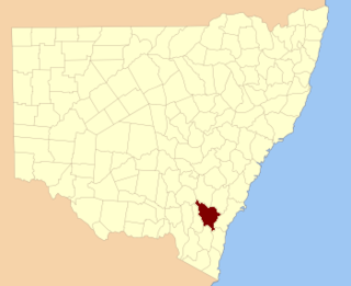
Murray County, New South Wales Cadastral in New South Wales, Australia

Murray County was one of the original Nineteen Counties in New South Wales and is now one of the 141 Lands administrative divisions of New South Wales. It included the area which is now part of Canberra and as far north as Lake George and Yass. It was originally bounded on the west by the Murrumbidgee River, on the east by the Shoalhaven River and on the north by the Yass River. A large area of the county was transferred to the Commonwealth government in 1909 in the Seat of Government Acceptance Act to make part of the Australian Capital Territory, along with land in Cowley County. Since then, the ACT border is now part of the western boundary. Part of the ACT border is determined by property boundaries in the Parish of Keewong, in the County of Murray; specifically the southern end of portions 177, 218, 211, 36, and 38. This is mentioned in the Seat of Government Acceptance Act of 1909.

Argyle County Cadastral in New South Wales, Australia

Argyle County was one of the original Nineteen Counties in New South Wales and is now one of the 141 Cadastral divisions of New South Wales. It includes the area around Goulburn. It is bounded by Lake George in the south-west, the Shoalhaven River in the east, and the Wollondilly River in the north-east.

Federal Highway (Australia) highway in New South Wales and the Australian Capital Territory

The Federal Highway is a highway in New South Wales and the Australian Capital Territory. It is a part of a motorway standard link between Sydney and Canberra, and is also the main thoroughfare between those cities.

Gearys Gap lookout, where the federal highway meets Lake George in the south, is just in the parish, on the very edge. From this point for about a mile northward the boundary of the parish is near the road, then further northward the parish includes the Lake George Range to the west of the road as well.

Old parish maps show the area was divided between Yarrowlumla Shire in the south, Gunning Shire in the west and Mulwaree Shire in the north-east. They also note the area was in the Pastures Protection Districts of Braidwood and Goulburn, and a Sanctuary for birds and animals was proclaimed for part of the area on 12 September 1919.

Yarrowlumla Shire was a local government area in New South Wales, which surrounded the Australian Capital Territory until February 2004, when it was divided between Palerang Council, Yass Valley Council, Queanbeyan City Council, Tumut Shire and a small part going to the Cooma-Monaro Shire. It had a population of 9,654 and an area of 2971 km² in 1999. The council was based in the municipality of Queanbeyan, outside its own territory as was common for rural shires at the time. Most of the area which became the ACT was in Yarrowlumla Shire before it was transferred to the Commonwealth in 1909. This included Yarralumla homestead, which it was named after, although using an alternative spelling.
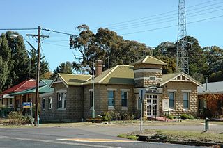
Gunning Shire

Gunning Shire was a local government area in New South Wales centered on Gunning, New South Wales north of the Australian Capital Territory until February 2004, when the local government organisation was absorbed into newly created Palerang Council and Upper Lachlan Shire.

Braidwood, New South Wales Town in New South Wales, Australia

Braidwood is a town in the Southern Tablelands of New South Wales, Australia, in Queanbeyan–Palerang Regional Council. It is located on the Kings Highway linking Canberra with Batemans Bay. It is approximately 200 kilometres south west of Sydney, 60 kilometres inland from the coast, and fifty-five from Canberra. Braidwood is a service town for the surrounding district which is based on sheep and cattle grazing, and forestry operations.

Related Research Articles

Interstate 87 (I-87) is a 333.49-mile-long (536.70 km) Interstate Highway located entirely within the U.S. state of New York, and is most of the main highway between New York City and Montreal. The highway begins in the Bronx borough of New York City, just north of the Triborough Bridge. From there, the route runs northward through the Hudson Valley, the Capital District, and the easternmost part of the North Country to the Canadian border in the Town of Champlain. At its north end, I-87 continues into Quebec as Autoroute 15 (A-15). I-87 connects with several regionally important roads: I-95 in New York City, New York State Route 17 near Harriman, I-84 near Newburgh, and I-90 in Albany. The route is the longest intrastate Interstate Highway in the Interstate Highway System. The highway is not contiguous with I-87 in North Carolina.

New York State Route 149 highway in New York and Vermont

New York State Route 149 (NY 149) is an east–west state highway that runs for 32.20 miles (51.82 km) through the Capital District of New York in the United States. It begins at exit 20 on the Adirondack Northway in the Warren County town of Queensbury and intersects U.S. Route 9 (US 9), US 4, and NY 22, among other routes, as it progresses eastward to its eastern end at the Vermont state line in the Washington County village of Granville. Here, the highway becomes Vermont Route 149 (VT 149) and continues for an additional 1.302 miles (2.095 km) to an intersection with VT 30 in Rutland County. Both NY 149 and VT 149 traverse mostly rural areas.

Texas State Highway Loop 12 highway in Texas

Loop 12 is a state highway that runs mostly within the city limits of Dallas, Texas. The western segment of the loop is named after General Walton Walker, who served and died in South Korea. During the 1950s and 1960s, Loop 12 was the outer beltway in the Dallas area, having since been supplanted by Interstate 635, which is itself being supplanted by the President George Bush Turnpike. Loop 12 is, however, the only state highway in Dallas that forms a complete loop.

Parish of Tuggeranong Cadastral in New South Wales, Australia

Tuggeranong Parish is a parish of Murray County, New South Wales, a cadastral unit for use on land titles. It is now about a third of the size it was in the nineteenth century, after most of the land in the parish was transferred to the Australian Capital Territory in 1911. It currently includes a small section of land in New South Wales between the ACT border and Jerrabomberra Creek, but once included most of what is now the Canberra town centre of Tuggeranong.

Hennepin County, Minnesota, United States maintains a number of county roads, many of them county state aid highways (CSAH). This includes a number of streets through the city of Minneapolis.

Parish of Amungula Cadastral in New South Wales, Australia

Amungula Parish is a parish of Murray County, New South Wales, a cadastral unit for use on land titles. It is located in two non-contiguous sections, divided by the Australian Capital Territory, as most of the parish was transferred to the ACT in 1909 and now makes up much of the Kowen district. The northern section, the larger of the two, is located just to the south of Wamboin around 35°15′50″S149°17′29″E; the southern, a section of land between the Goulburn-Queanbeyan railway and the Molonglo River around 35°20′48″S149°19′49″E. Before 1909, the Molonglo River was the southern boundary of the parish. The Kings Highway passes through a small part of the southern remaining portion. It was formerly located in Yarrowlumla Shire, but is now located in Queanbeyan-Palerang Regional Council.

Parish of Majura Cadastral in New South Wales, Australia

Majura Parish is a parish of Murray County, New South Wales, a cadastral unit for use on land titles. It is located to the east of the extreme eastern tip of the ACT. The Queanbeyan-Bungendore railway line and the Kings Highway pass through the parish. About a quarter of the original nineteenth-century parish was transferred to the ACT in 1909. The land transferred was the area between the railway line in the south and the watershed of the Molonglo River in the north. This cut off part of portion 210 of Majura Parish from the rest, giving the parish a small exclave.

Parish of Carwoola Cadastral in New South Wales, Australia

Carwoola Parish is a parish of Murray County, a cadastral unit for use on land titles. It is located to the south of the Australian Capital Territory and to the south-east of Queanbeyan. The original northern and eastern boundary was the Molonglo River; this is still the boundary for most of the parish, except in the north, where the relatively small area north of the Queanbeyan-Goulburn railway line was transferred to the ACT in 1909. The south-western boundary is the Queanbeyan River. Captain's Flat Road is the major road running through the parish. The area also roughly aligns with the locality of Carwoola.

Wallaroo Parish is one of the 54 parishes of Murray County, New South Wales, a cadastral unit for use on land titles. It is bounded by the Murrumbidgee River in the west, Ginninderra Creek in the south and Gooromon Ponds in the east. The Australian Capital Territory has also formed a small part of the boundary since 1909, after a small part of land in the parish at 35°11′54″S149°00′00″E was transferred to the Commonwealth. This area is just to the west of Dunlop. The Wallaroo road is the main road in the area, which comes off the Barton Highway. The parish is similar to the locality of Wallaroo.

Parish of Marulan Cadastral in New South Wales, Australia

The Parish of Marulan is a parish of Argyle County located with the Goulburn Mulwaree local government area, which includes the towns of Marulan and Marulan South. The parish is bounded by Barbers Creek to the east, a small part of the Shoalhaven River to the south-east, and Jerrara Creek to the south. The Hume Highway and the Southern Highlands railway line run through the parish. Jerrara Road and Marulan South Road are other main roads in the area.

Bong Bong Parish Cadastral in New South Wales, Australia

The Parish of Bong Bong is a parish of the County of Camden in the Southern Highlands region of New South Wales. Moss Vale is the largest town in the area. The parish includes the small township of Bong Bong, which was the first village established in the Southern Highlands. The Wingecarribee River forms part of the boundary of the parish in the north and north-east. The Hume Highway passes through a small part of the parish in the north-west. Bowral is just beyond the boundary of the parish in the north-east. Berrima is located just to the north-west. The Illawarra Highway passes through the parish from east to west, and is also a small part of the boundary in the south-west.

The Parish of Mittagong is a parish of the County of Camden in the Southern Highlands region of New South Wales. It includes the town of Bowral and the southern parts of Mittagong.

The Parish of Wamboin is a parish of the County of Murray, a cadastral unit for use on land titles. It is located just to the north-east of the Australian Capital Territory and includes part of the town of Bungendore on the eastern edge and the rural community of Wamboin near the south-western edge.

The Parish of Collector is a parish of Argyle County located to the north of Lake George.

The Parish of Wologorong is a parish of Argyle County, New South Wales, Australia.

Parish of Towrang Cadastral in New South Wales, Australia

The Parish of Towrang is a parish of Argyle County located to the south-east of Goulburn, and including some of its outer suburbs such as Goulburn North, and the area to the east of the Wollondilly River and Mulwaree Ponds. The Goulburn War Memorial is also located in this parish. The village of Towrang is located at the north-eastern edge of the parish, with Towrang creek part of the boundary in this area.

The Parish of Nattery is a parish of Argyle County located between Goulburn and Marulan in New South Wales. It is just east of the village of Towrang and includes the locality of Carrick. The Wollondilly River is the boundary in the north-west. Jerraba creek is part of the boundary in the south-east. The Southern Highlands railway line runs through the northern end of the parish, to the east of the Wollondilly river. The Hume Highway passes through the middle of the parish.

References

The Geographical Names Board of New South Wales, a statutory authority of the Land and Property Information division, Department of Finance and Services in the Government of New South Wales, is the official body for naming and recording details of places and geographical names in the state of New South Wales, Australia.

Coordinates: 35°05′S149°25′E / 35.083°S 149.417°E / -35.083; 149.417

Geographic coordinate system Coordinate system

A geographic coordinate system is a coordinate system that enables every location on Earth to be specified by a set of numbers, letters or symbols. The coordinates are often chosen such that one of the numbers represents a vertical position and two or three of the numbers represent a horizontal position; alternatively, a geographic position may be expressed in a combined three-dimensional Cartesian vector. A common choice of coordinates is latitude, longitude and elevation. To specify a location on a plane requires a map projection.