
Longdendale is a valley in the Peak District of England, north of Glossop and southwest of Holmfirth. The name means "long wooded valley" and the valley is mostly in the counties of Derbyshire and Greater Manchester.

Tameside is a metropolitan borough of Greater Manchester, England, named after the River Tame, which flows through it, and includes the towns of Ashton-under-Lyne, Audenshaw, Denton, Droylsden, Dukinfield, Hyde, Mossley and Stalybridge. Tameside is bordered by the metropolitan boroughs of Stockport to the south, Oldham to the north and northeast, Manchester to the west, and to the east by the Borough of High Peak in Derbyshire. As of 2022, the population of Tameside was 232,753, making it the 8th-most populous borough of Greater Manchester.

Stalybridge is a town in Tameside, Greater Manchester, England, with a population of 23,731 at the 2011 Census.
Denton is a town in Tameside, Greater Manchester, England, five miles (8 km) east of Manchester city centre. Historically part of Lancashire, it had a population of 36,591 at the 2011 Census.

Ashton-under-Lyne is a market town in Tameside, Greater Manchester, England. The population was 48,604 at the 2021 census. Historically in Lancashire, it is on the north bank of the River Tame, in the foothills of the Pennines, 6 miles (9.7 km) east of Manchester.

Dukinfield is a town in Tameside, Greater Manchester, England, on the south bank of the River Tame opposite Ashton-under-Lyne, 6.3 miles (10.1 km) east of Manchester. At the 2011 Census, it had a population of 19,306.

Audenshaw is a town in Tameside, Greater Manchester, England, 4.9 miles (7.9 km) east of Manchester. Historically part of Lancashire, in 2011 it had a population of 11,419.

Mossley (/ˈmɒzli/) is a town and civil parish in Tameside, Greater Manchester, England. It is located in the upper Tame Valley and the foothills of the Pennines, 3 miles (4.8 km) south-east of Oldham and 9 miles (14.5 km) east of Manchester. In 2011 it had a population of 10,921.

Droylsden is a town in Tameside, Greater Manchester, England, 4.1 miles (6.6 km) east of Manchester city centre and 2.2 miles (3.5 km) west of Ashton-under-Lyne, with a population at the 2011 Census of 22,689.
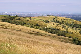
Werneth Low is a hill in Greater Manchester, England, and a part of the Pennines. It is located on the border of Stockport and Tameside, rising to a height of 279 metres (915 ft). The villages of Woodley, Greave, Gee Cross, Mottram and Romiley lie on the sides of the low.

Nico Ditch is a six-mile (9.7 km) long linear earthwork between Ashton-under-Lyne and Stretford in Greater Manchester, England. It was dug as a defensive fortification, or possibly a boundary marker, between the 5th and 11th century. The ditch is still visible in short sections, such as a 330-yard (300 m) stretch in Denton Golf Course. For the parts which survived, the ditch is 4–5 yards (3.7–4.6 m) wide and up to 5 feet (1.5 m) deep. Part of the earthwork is protected as a Scheduled Ancient Monument.

Hartshead Pike is a hill in Tameside in Greater Manchester, England, and its name is associated with the monument on its summit. It overlooks Ashton-under-Lyne, Mossley, Saddleworth, Lees and Oldham. On a clear day you can get views of Manchester, Cheshire and Snowdonia in Wales. Hartshead Pike Tower has been a Grade II listed building since 1967.

Bardsley is a suburban area of Oldham, in Greater Manchester, England.

St Lawrence's Church in Denton is a timber-framed church and a Grade II* listed building; it is one of only 29 surviving timber framed churches and chapels in England. The chapelry of Denton was established in 1531 with the construction of the chapel of ease, then Roman Catholic in the Diocese of Lichfield and dedicated to St James.

St. Michael's Church is an Anglican parish church in Ashton-under-Lyne, Tameside, Greater Manchester, England. The church is a Grade I Listed Building. The church dates back to at least 1262, and a church on the site was mentioned in the Domesday Book. The church was rebuilt in the fifteenth century; however little of the previous church remains after it was rebuilt again in the nineteenth century and is still an active place of worship.
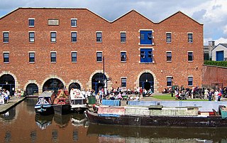
Dukinfield Junction is the name of the canal junction where the Peak Forest Canal, the Ashton Canal and the Huddersfield Narrow Canal meet near Ashton-under-Lyne, Greater Manchester, England. The area has been designated by Tameside Metropolitan Borough Council as a conservation area.

There are 37 scheduled monuments in Greater Manchester, a metropolitan county in North West England. In the United Kingdom, a scheduled monument is a "nationally important" archaeological site or historic building that has been given protection against unauthorised change by being placed on a list by the Secretary of State for Digital Culture, Media and Sport; Historic England recommends sites for scheduling to the Secretary of State. Scheduled monuments are defined in the Ancient Monuments and Archaeological Areas Act 1979 and the National Heritage Act 1983. There are nearly 20,000 entries on the schedule, which is maintained by Historic England as part of the National Heritage List for England; more than one site can be included in a single entry. While a scheduled monument can also be recognised as a listed building, Historic England's aim is to set the most appropriate form of protection in place for the building or site. Applications to deschedule a site are administered Historic England, who will carry out an assessment and make a recommendation to the Secretary of State.
Ryecroft is an area of Ashton-under-Lyne, a town in Greater Manchester, England. It occupies a western area of Ashton.

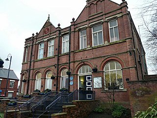
Ashton Town Hall is a public building on Katherine Street in Ashton-under-Lyne, Greater Manchester, England. It is a Grade II listed building.


