Related Research Articles

The San Luis Valley is a region in south-central Colorado with a small portion overlapping into New Mexico. The valley is approximately 122 miles (196 km) long and 74 miles (119 km) wide, extending from the Continental Divide on the northwest rim into New Mexico on the south. It contains 6 counties and portions of 3 others. It is an extensive high-altitude depositional basin of approximately 8,000 square miles (21,000 km2) with an average elevation of 7,664 feet (2,336 m) above sea level. The valley is a section of the Rio Grande Rift and is drained to the south by the Rio Grande, which rises in the San Juan Mountains to the west of the valley and flows south into New Mexico. The San Luis Valley has a cold desert climate but has substantial water resources from the Rio Grande and groundwater.
The Denver & Rio Grande Western Railroad, often shortened to Rio Grande, D&RG or D&RGW, formerly the Denver & Rio Grande Railroad, was an American Class I railroad company. The railroad started as a 3 ft narrow-gauge line running south from Denver, Colorado, in 1870. It served mainly as a transcontinental bridge line between Denver, and Salt Lake City, Utah. The Rio Grande was also a major origin of coal and mineral traffic.

Rio Grande County is a county located in the U.S. state of Colorado. As of the 2020 census, the population was 11,539. The county seat is Del Norte. The county is named for the Rio Grande, which flows through the county.

Alamosa County is a county located in the U.S. state of Colorado. As of the 2020 census, the population was 16,376. The county seat is Alamosa. The county name is the Spanish language word for a "grove of cottonwood trees."
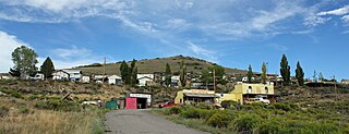
The Town of Hooper is a Statutory Town located in the San Luis Valley in Alamosa County, Colorado, United States. The population was 103 at the 2010 census.
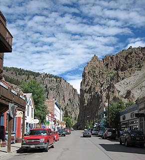
The historic City of Creede is the Statutory Town that is a town in and the county seat of Mineral County, Colorado, United States, that is the most populous community and the only incorporated municipality within the county. The town population was 257 at the 2020 United States Census.

The City of Monte Vista is the home rule municipality that is the most populous municipality in Rio Grande County, Colorado, United States. The city population was 4,444 at the 2010 United States Census.
The San Luis and Rio Grande Railroad is a class III railroad operating in south-central Colorado. It runs on 154 miles of former Denver and Rio Grande Western Railroad tracks on three lines radiating from Alamosa and interchanges with the Union Pacific Railroad in Walsenburg. Much of the railroad is located in the San Luis Valley.

Sargents is an unincorporated community and a U.S. Post Office in Saguache County, Colorado, United States. The Sargents Post Office has the ZIP code 81248.

Toponas is an unincorporated community in Routt County, Colorado, United States.
Sapinero is an unincorporated community located on U.S. Route 50, along the shore of Blue Mesa Reservoir in the Curecanti National Recreation Area in Gunnison County, Colorado, United States.
Osier is a populated place in Conejos County, Colorado, USA. It is an old railroad settlement and train stop approximately halfway along the Cumbres and Toltec Scenic Railroad where trains from both ends of the line meet and stop for lunch, making it possible for passengers to either continue in the same direction or return to their point of origin afterwards.

The Rio Grande Scenic Railroad of Colorado was a heritage railway that operated from 2006 to 2019 in and around the San Luis Valley as a subsidiary of the San Luis and Rio Grande Railroad. The heritage railroad ceased operating excursions following a wildfire that damaged some of their facilities, as well as the parent company SLRG entering Chapter 11 bankruptcy in late 2019.
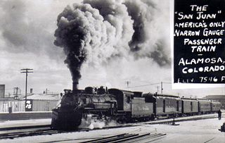
The San Juan Express was a narrow gauge train that ran on the 3 feet (0.91 m) Denver & Rio Grande Western Railroad (D&RGW) route from Durango, Colorado via Chama, New Mexico; Cumbres Pass; and Antonito, Colorado to Alamosa, Colorado. The train ran from February 11, 1937 until January 31, 1951 as train numbers 115 and 116, though towards the end of the passenger service it took on the number 215 and 216.
Sublette is a railroad town in northern Rio Arriba County, New Mexico, United States, built as a section station in 1880. It is located north-east of Chama, just south of the Colorado state line and at milepost 306.1 of the former Denver and Rio Grande Western Railroad. When the Denver and Rio Grande abandoned its narrow gauge lines in the late 1960s, two parts of the system were preserved independently: the Cumbres & Toltec Scenic Railroad from Antonito to Chama, including Sublette itself, and the Durango and Silverton Narrow Gauge Railroad. Sublette sits at an elevation of 9,281 feet in the southeastern San Juan Mountains.

La Veta Pass is the name associated with two nearby mountain passes in the Sangre de Cristo Mountains of south central Colorado in the United States, both lying on the boundary between Costilla and Huerfano counties.

The Alamosa–Durango line or San Juan extension was a railroad line built by the Denver and Rio Grande Western Railroad, following the border between the U.S. states of Colorado and New Mexico, in the Rocky Mountains. The line was originally built as a 3 ft narrow-gauge line between Alamosa, Colorado, and Durango, Colorado. Portions of the route survive to this day: the now standard-gauged segment from Alamosa to Antonito, Colorado, and a narrow-gauge portion from Antonito to Chama, New Mexico.

Bountiful is an unincorporated community in Conejos County, in the U.S. state of Colorado.

Doyleville is an unincorporated community in Gunnison County, in the U.S. state of Colorado. It is located 19 miles (31 km) east of Gunnison on U.S. Highway 50.
References
- 1 2 3 U.S. Geological Survey Geographic Names Information System: Parma, Colorado
- ↑ D&RG / D&RGW Creede Branch History, DRGW.net, Retrieved 24 October 2022
- ↑ (6 June 1903). Parma Station..., Monte Vista Journal
- ↑ "Post offices". Jim Forte Postal History. Retrieved 6 July 2016.
- ↑ Dawson, John Frank. Place names in Colorado: why 700 communities were so named, 150 of Spanish or Indian origin. Denver, CO: The J. Frank Dawson Publishing Co. p. 40.
Municipalities and communities of Alamosa County, Colorado, United States | ||
|---|---|---|
| City |  | |
| Town | ||
| CDP | ||
| Unincorporated communities | ||
| Footnotes | ‡This populated place also has portions in an adjacent county or counties | |
Municipalities and communities of Rio Grande County, Colorado, United States | ||
|---|---|---|
| City |  | |
| Towns | ||
| CDPs | ||
| Unincorporated community | ||
| Footnotes | ‡This populated place also has portions in an adjacent county or counties | |
Coordinates: 37°32′14″N106°02′19″W / 37.53722°N 106.03861°W
| | This Colorado state location article is a stub. You can help Wikipedia by expanding it. |