Alamosa East, Colorado

Last updated
Alamosa East, Colorado
Alamosa East, Colorado.JPG
Looking east along U.S. Route 160 (Santa Fe Avenue) in Alamosa East.
Alamosa County Colorado Incorporated and Unincorporated areas Alamosa East Highlighted.svg
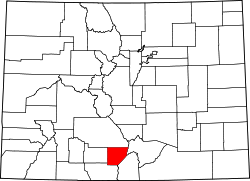
Location of the Alamosa East CDP in Alamosa County, Colorado
Usa edcp location map.svg
Red pog.svg
Alamosa East
Location of the Alamosa East CDP in the United States.
Coordinates: 37°28′36″N105°50′23″W / 37.4766704°N 105.8397189°W / 37.4766704; -105.8397189 (Alamosa East CDP, Colorado) Coordinates: 37°28′36″N105°50′23″W / 37.4766704°N 105.8397189°W / 37.4766704; -105.8397189 (Alamosa East CDP, Colorado) [1]
Country Flag of the United States.svg  United States
State Flag of Colorado.svg  Colorado
County Alamosa County
Government
[2]
  Type unincorporated community
Area
[1]
  Total3.249 sq mi (8.414 km2)
  Land3.249 sq mi (8.414 km2)
  Water0.000 sq mi (0.000 km2)
Elevation
[2]
7,536 ft (2,297 m)
Population
 (2020) [1]
  Total1,453
  Density450/sq mi (170/km2)
Time zone UTC-7 (MST)
  Summer (DST) UTC-6 (MDT)
ZIP Code [3]
Alamosa 81101
Area code(s) 719
GNIS feature [2] Alamosa East CDP

Alamosa East is an unincorporated community and a census-designated place (CDP) located in and governed by Alamosa County, Colorado, United States. The population of the Alamosa East CDP was 1,453 at the United States Census 2020. [1] The Alamosa post office (Zip code 81101) serves the area. [3]

Contents

Geography

The Alamosa East CDP has an area of 2,079 acres (8.414 km2), all land. [1]

Demographics

The United States Census Bureau initially defined the Alamosa East CDP for the 1970 United States Census.

Alamosa East CDP, Colorado
YearPop.±%
1970 1,040    
1980 1,175+13.0%
1990 1,389+18.2%
2000 1,528+10.0%
2010 1,458−4.6%
2020 1,453−0.3%
Source: United States Census Bureau

See also

Related Research Articles

<span class="mw-page-title-main">Columbine, Colorado</span> Census Designated Place in Colorado, United States

Columbine is an unincorporated community and a census-designated place (CDP) located in and governed by Jefferson and Arapahoe counties, Colorado, United States. The CDP is a part of the Denver–Aurora–Lakewood, CO Metropolitan Statistical Area. Located primarily in Jefferson County, Columbine lies immediately south of Denver. The population of the Columbine CDP was 24,280 at the United States Census 2010. The community lies in ZIP code 80123.

Kittredge, Colorado Census Designated Place in Colorado, United States

Kittredge is an unincorporated town, a post office, and a census-designated place (CDP) located in and governed by Jefferson County, Colorado, United States. The CDP is a part of the Denver–Aurora–Lakewood, CO Metropolitan Statistical Area. The Kittredge post office has the ZIP code 80457. At the United States Census 2010, the population of the Kittredge CDP was 1,304, while the population of the 80457 ZIP Code Tabulation Area was 612.

<span class="mw-page-title-main">Grand View Estates, Colorado</span> Census Designated Place in Colorado, United States

Grand View Estates is an unincorporated community and a census-designated place (CDP) located in and governed by Douglas County, Colorado, United States. The CDP is a part of the Denver–Aurora–Lakewood, CO Metropolitan Statistical Area. The population of the Grand View Estates CDP was 528 at the United States Census 2010. The area lies in ZIP code 80134..

<span class="mw-page-title-main">East Pleasant View, Colorado</span> Census Designated Place in Colorado, United States

East Pleasant View is an unincorporated community and a census-designated place (CDP) located in and governed by Jefferson County, Colorado, United States. The CDP is a part of the Denver–Aurora–Lakewood, CO Metropolitan Statistical Area. The population of the East Pleasant View CDP was 356 at the United States Census 2010. The Pleasant View Metropolitan District provides services. The Golden Post Office serves the area.

Divide, Colorado Census Designated Place in Colorado, United States

Divide is an unincorporated town, a post office, and a census-designated place (CDP) located in and governed by Teller County, Colorado, United States. The CDP is a part of the Colorado Springs, CO Metropolitan Statistical Area. The Divide post office has the ZIP Code 80814. At the United States Census 2010, the population of the Divide CDP was 127, while the population of the 80814 ZIP Code Tabulation Area was 4,023 including adjacent areas.

Florissant, Colorado Census Designated Place in Colorado, United States

Florissant is an unincorporated town, a post office, and a census-designated place (CDP) located in and governed by Teller County, Colorado, United States. The CDP is a part of the Colorado Springs, CO Metropolitan Statistical Area. The Florissant post office has the ZIP Code 80816. At the United States Census 2010, the population of the Florissant CDP was 104, while the population of the 80816 ZIP Code Tabulation Area was 5,180 including adjacent areas.

Twin Lakes, Lake County, Colorado Census Designated Place in Colorado, United States

Twin Lakes is an unincorporated town, a census-designated place (CDP), and a post office located in and governed by Lake County, Colorado, United States. The Twin Lakes post office has the ZIP Code 81251. At the United States Census 2010, the population of the Twin Lakes CDP was 171, while the population of the 81251 ZIP Code Tabulation Area was 220 including adjacent areas.

Conejos, Colorado Census Designated Place in Colorado, United States

Conejos is an unincorporated town, a post office, a census-designated place (CDP), and the county seat of Conejos County, Colorado, United States. The Conejos post office has the ZIP Code 81129. At the United States Census 2010, the population of the Conejos CDP was 58, while the population of the 81129 ZIP Code Tabulation Area was 156 including adjacent areas. Conejos is the only unincorporated county seat in the State of Colorado.

Redvale, Colorado Census Designated Place in Colorado, United States

Redvale is an unincorporated town, a post office, and a census-designated place (CDP) located in and governed by Montrose County, Colorado, United States. The CDP is a part of the Montrose, CO Micropolitan Statistical Area. The Redvale post office has the ZIP Code 81431. At the United States Census 2010, the population of the Redvale CDP was 236, while the population of the 81431 ZIP Code Tabulation Area was 460 including adjacent areas.

Ellicott, Colorado Census Designated Place in Colorado, United States

Ellicott is an unincorporated community and a census-designated place (CDP) located in and governed by El Paso County, Colorado, United States. The CDP is a part of the Colorado Springs, CO Metropolitan Statistical Area. The population of the Ellicott CDP was 1,131 at the United States Census 2010. The Calhan post office serves the area.

Alpine, Colorado Census Designated Place in Colorado, United States

Alpine is an unincorporated community and a census-designated place (CDP) located in and governed by Rio Grande County, Colorado, United States. The population of the Alpine CDP was 169 at the United States Census 2020. The South Fork post office (Zip Code 81154) serves the area.

Peoria, Colorado Census Designated Place in Colorado, United States

Peoria is an unincorporated community and a census-designated place (CDP) located in and governed by Arapahoe County, Colorado, United States. The CDP is a part of the Denver–Aurora–Lakewood, CO Metropolitan Statistical Area. The population of the Peoria CDP was 163 at the United States Census 2010. The Byers post office serves the area.

Dakota Ridge, Colorado Census Designated Place in Colorado, United States

Dakota Ridge is an unincorporated community and a census-designated place (CDP) located in and governed by Jefferson County, Colorado, United States. The CDP is a part of the Denver–Aurora–Lakewood, CO Metropolitan Statistical Area. The population of the Dakota Ridge CDP was 32,005 at the United States Census 2010. In 1988, voters turned down a proposal to incorporate Dakota Ridge. The community lies in ZIP codes 80127 and 80465.

Fairmount, Colorado Census Designated Place in Colorado, United States

Fairmount is an unincorporated community and a census-designated place (CDP) in Jefferson County, Colorado, United States. The CDP is a part of the Denver–Aurora–Lakewood, CO Metropolitan Statistical Area. The population of the Fairmount CDP was 7,559 at the United States Census 2010. ZIP code 80403 applies to addresses in Fairmount.

Bark Ranch, Colorado Census Designated Place in Colorado, United States

Bark Ranch is an unincorporated community and a census-designated place (CDP) located in and governed by Boulder County, Colorado, United States. The Bark Ranch CDP encompasses the Bar-K Ranch housing community. The CDP is a part of the Boulder, CO Metropolitan Statistical Area. The population of the Bark Ranch CDP was 213 at the United States Census 2010. The Ward post office serves the area.

Bonanza Mountain Estates, Colorado Census Designated Place in Colorado, United States

Bonanza Mountain Estates is an unincorporated community and a census-designated place (CDP) located in and governed by Boulder County, Colorado, United States. The CDP is a part of the Boulder, CO Metropolitan Statistical Area. The population of the Bonanza Mountain Estates CDP was 128 at the United States Census 2010. The Nederland post office serves the area.

Glendale, Boulder County, Colorado Census Designated Place in Colorado, United States

Glendale is an unincorporated community and a census-designated place (CDP) located in and governed by Boulder County, Colorado, United States. The CDP is a part of the Boulder, CO Metropolitan Statistical Area. The population of the Glendale CDP was 69 at the United States Census 2010. The Jamestown post office serves the area.

Mulford, Colorado Census Designated Place in Colorado, United States

Mulford is an unincorporated community and a census-designated place (CDP) located in and governed by Garfield County, Colorado, United States. The CDP is a part of the Glenwood Springs, CO Micropolitan Statistical Area. The population of the Mulford CDP was 174 at the United States Census 2010. The Carbondale post office serves the area.

Garfield, Colorado Census Designated Place in Colorado, United States

Garfield is an unincorporated community and a census-designated place (CDP) located in and governed by Chaffee County, Colorado, United States. The population of the Garfield CDP was 15 at the United States Census 2010. The Salida post office serves the area.

Vineland, Colorado Census Designated Place in Colorado, United States

Vineland is an unincorporated community and a census-designated place (CDP) located in and governed by Pueblo County, Colorado, United States. The CDP is a part of the Pueblo, CO Metropolitan Statistical Area. The population of the Vineland CDP was 251 at the United States Census 2010. The Pueblo post office (Zip Code 81006) serves the area.

References

  1. 1 2 3 4 5 "State of Colorado Census Designated Places - BAS20 - Data as of January 1, 2020". United States Census Bureau . Retrieved November 5, 2021.
  2. 1 2 3 "U.S. Board on Geographic Names: Domestic Names". United States Geological Survey . Retrieved December 2, 2020.
  3. 1 2 "Zip Code 81101 Map and Profile". zipdatamaps.com. 2020. Retrieved December 20, 2020.